Rio San Jose facts for kids
Quick facts for kids Rio San Jose |
|
|---|---|

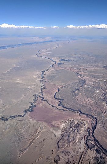
Aerial view from west of Albuquerque of the last few miles of the Rio San Jose (bottom right) as it merges with the Rio Puerco, which flows to the Rio Grande in the distance
|
|

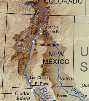
Map of the Rio Grande watershed, showing the Rio San Jose joining the Rio Puerco near Albuquerque
|
|
| Country | United States |
| State | New Mexico |
| County | Cibola, Valencia, Bernalillo |
| Physical characteristics | |
| Main source | Zuni Mountains Bluewater Village, Valencia County 6,651 ft (2,027 m) 35°17′14″N 107°59′58″W / 35.28722°N 107.99944°W |
| River mouth | Rio Puerco near Isleta Pueblo, Bernalillo County 5,102 ft (1,555 m) 34°52′50″N 107°01′40″W / 34.88056°N 107.02778°W |
| Length | 90 mi (140 km) |
| Basin features | |
| Basin size | 2,597 sq mi (6,730 km2) |
The Rio San Jose is a river in New Mexico, USA. It flows for about 90 miles (145 km). This river is a tributary, which means it's a smaller river that flows into a larger one. The Rio San Jose joins the Rio Puerco, which then flows into the even bigger Rio Grande.
Contents
Where Does the Rio San Jose Flow?
The journey of the Rio San Jose begins high up in the Zuni Mountains. Its main starting point is a stream called Bluewater Creek. This creek is near the continental divide, which is like a big ridge where water flows to different oceans.
Bluewater Lake and the River's Start
Bluewater Creek is held back by a dam, forming a lake called Bluewater Lake. This lake can hold a lot of water, about 43,500 acre-feet! The Rio San Jose officially starts where Bluewater Creek meets another stream called Mitchell Draw, near a place called Bluewater Village.
Journey Through New Mexico
From Bluewater Village, the river flows southeast. It passes through towns like Grants. Then, near McCartys, it turns east. The river continues its path through important areas like the Acoma Indian Reservation and Laguna Pueblo. The Laguna people built an old dam on the river a long time ago, between 1370 and 1750 AD.
After passing Mesita, the river turns southeast again. It flows through a narrow canyon before finally meeting the Rio Puerco in Bernalillo County.
Following the River's Path
For much of its journey, the Rio San Jose runs alongside important transportation routes. The BNSF Railway tracks follow the river's course. These tracks were first built around 1882. Also, old U.S. Route 66 and I-40 (a major highway) run parallel to the river between Bluewater Village and Mesita.
How Much Water Does the Rio San Jose Carry?
Scientists measure the water level and flow of the Rio San Jose to understand how much water it carries. This is called hydrology. The USGS uses special tools called stream gauges to do this. They have measured the river at several spots, including near Laguna, Correo, and at Acoma Pueblo.
Measuring River Flow
The stream gauge at Acoma Pueblo has been recording data since 1937 and is still active today. It measures water coming from an area of about 1,170 square miles (3,030 km²). The average flow of the river between 1937 and 2016 was about 6 cubic feet per second. The lowest flow ever recorded was in July 2014, at 1.3 cubic feet per second.
The highest water level recorded was in September 1963. The river rose to 4.87 feet (1.48 meters) at the gauge, with a flow of about 1,400 cubic feet per second. However, this high flow was partly due to water being moved or controlled by people.
Changes in River Flow Over Time
Since the 1870s, the amount of water in the upper part of the river has changed a lot. This is because people use water for farming (irrigation), pump water from underground (groundwater abstraction), and because of the dam on Bluewater Creek. A study in 1982 showed that the river's natural flow should have been much higher, between 16.6 and 19.3 cubic feet per second, compared to the measured average of 6.7 cubic feet per second. This shows how human activities can affect a river's natural state.
 | Audre Lorde |
 | John Berry Meachum |
 | Ferdinand Lee Barnett |


