
Petroglyph National Monument facts for kids
Quick facts for kids Petroglyph National Monument |
|
|---|---|
|
IUCN Category III (Natural Monument)
|
|
.jpg)
Aerial photo of the Petroglyph National Monument
|
|

Petroglyph National Monument
Location in New Mexico

Petroglyph National Monument
Location in the United States
|
|
| Location | Bernalillo County, New Mexico, US |
| Nearest city | Albuquerque, NM |
| Area | 7,532 acres (30.48 km2) |
| Authorized | June 27, 1990 |
| Visitors | 124,177 (in 2016) |
| Governing body | National Park Service |
| Website | Petroglyph National Monument |


Petroglyph National Monument is a special place in New Mexico, near the city of Albuquerque. It stretches for about 17 miles (27 kilometers) along the city's western edge, on a rocky area called the West Mesa. This monument was created on June 27, 1990, to protect important cultural and natural treasures. It covers about 7,236 acres and is looked after by the National Park Service and the City of Albuquerque.
The monument protects five volcanic cones and thousands of ancient rock carvings called petroglyphs. There are an estimated 24,000 images carved into the rocks! These carvings were made by Pueblo people long ago and by early Spanish settlers. Some images show animals, people, or symbols like crosses. Others are more mysterious, and their meaning might have been known only by the person who carved them.
The monument also features a chain of old, inactive volcanoes. These include Butte, Bond, Vulcan, Black, and JA volcanoes. Visitors can explore four main areas: Boca Negra Canyon, Rinconada Canyon, Piedras Marcadas Canyon, and the Volcano Day Use trails.
Contents
How the Land Was Formed
About 200,000 years ago, there were six big volcanic eruptions in this area. These eruptions created a long cliff, about 17 miles (27 kilometers) long, made of thick layers of hard, cooled lava rock called basalt. When the volcanoes erupted, hot, melted lava flowed downhill. It moved through old streambeds, called arroyos.
Over time, these lava flows created unique, triangular-shaped channels around hills. The softer hills have worn away over thousands of years, but the strong basalt rocks remained. These rocks eventually cracked, forming the canyons and cliffs you see today. More eruptions happened later, creating the tall, inactive volcanic cones that stand to the west of the monument. This interesting way the land was shaped is called "reverse topography."
The Story of Desert Varnish
The basalt rocks are perfect for creating petroglyphs. These rocks contain a lot of iron, manganese, and calcium, which gives them a gray color. However, after thousands of years in the desert, a dark, shiny coating forms on the surface. This coating is called "desert varnish."
Desert varnish forms when the iron and manganese in the rock mix with oxygen in the air and water from rain. This process is like rusting, and it makes the rock surface turn dark, almost black, and glossy. Long ago, Native Americans and Spanish settlers discovered that they could chip away this dark layer using other rocks and tools. This revealed the lighter rock underneath, creating lasting images on the stone.
Ancient Messages: Cultural History
The petroglyph images at the monument are very important to the Pueblo people and other Native groups. These rock carvings have many different and deep meanings.
Archaeologists, who study ancient cultures, believe some carvings are as old as 3,000 years. They can guess the age by how dark the image is, where it's located, and by comparing it to other carvings from the same time. Most of the petroglyphs, about 90 percent, were likely made between the years 1300 AD and the late 1600s. This was a time when many Native people lived in the area.
During this period, the Native population was growing quickly. Pueblo villages, made of adobe (a type of mud brick), were being built along the Rio Grande river and at the base of the Sandia Mountains. These carvings tell stories and share beliefs from these ancient communities.
Pictures of Petroglyphs


Pictures of Volcanoes
-
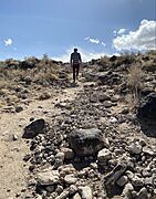
Trail up to top of Black Volcano
-
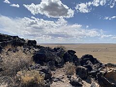
Rocks at the top of Black Volcano
-
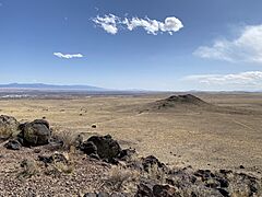
Looking toward JA Volcano
-
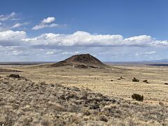
Looking toward Vulcan Volcano while on the volcanoes trail


Learn More
- List of national monuments of the United States
- List of petroglyph sites
- List of Stone Age art
See also
 In Spanish: Monumento nacional de los Petroglifos para niños
