
Sandia Mountains facts for kids
Quick facts for kids Sandia Mountains |
|
|---|---|

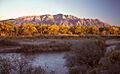
The Sandia Mountains and Rio Grande at sunset, looking southeast from Bernalillo
|
|
| Highest point | |
| Peak | Sandia Crest |
| Elevation | 10,678 ft (3,255 m) |
| Prominence | 4,201 ft (1,280 m) (crest) |
| Dimensions | |
| Length | 17 mi (27 km) N-S |
| Width | 8 mi (13 km) E-W |
| Naming | |
| Language of name | Dził Nááyisí (Navajo) |
| Geography | |

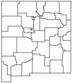
Location of the Sandia Mountains within New Mexico
|
|
| Country | United States |
| State | New Mexico |
| Parent range | Sandia–Manzano Mountains |
| Borders on | Albuquerque, NM |
The Sandia Mountains are a mountain range in New Mexico, USA. They are located just east of the city of Albuquerque. These mountains are part of the larger Sandia–Manzano Mountains and are found south of the Rocky Mountains. Much of the Sandias are protected within the Cibola National Forest as the Sandia Mountain Wilderness. The highest point is called Sandia Crest, which is 10,678 feet (3,255 meters) high.
The mountains have different names in local Native American languages. For example, in Southern Tiwa, they are called Posu gai hoo-oo. In Navajo, they are known as Dził Nááyisí.
Contents
What Does "Sandia" Mean?
The name Sandía means watermelon in Spanish. Many people believe the mountains got this name because they look reddish at sunset, like a watermelon. Also, from the west, the mountains look like a long ridge. A thin green line of trees near the top might look like the "rind" of a watermelon.
However, another idea comes from the Sandia Pueblo Indians. They believe that when the Spanish explorers arrived in 1540, they saw squash plants growing there. The Spanish thought these were watermelons and called the area "Sandia." This name then moved to the mountains.
In the Southern Tiwa language, Posu gai hoo-oo means "where water slides down a dry creek." The Sandia Pueblo Indians, who speak Tiwa, sometimes also call the mountain Bien Mur, which means "big mountain."
How Are the Sandia Mountains Shaped?
The Sandia Mountains are a small range. They are part of the Basin and Range Province, which is a large area of mountains and valleys. The Sandias form a single ridge that runs from north to south.
The range has two main peaks: Sandia Crest and South Sandia Peak, which is 9,702 feet (2,957 meters) high. The mountains are about 17 miles (26 km) long from north to south. They are about 4 to 8 miles (6 to 12 km) wide from east to west.

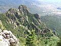
The west side of the mountains is very steep and rugged. It has many rock walls and tall rock formations near Sandia Crest. The east side of the mountains has a gentler slope.
Neighboring Mountain Ranges
The Sandia Mountains are connected to a larger group of mountains called the Sandia–Manzano Mountains. This group also includes the Manzanita Mountains and the Manzano Mountains. The Manzanita Mountains separate the Sandias from the Manzano Mountains.
A special feature in the Sandias is Tijeras Canyon. This canyon has been an important pass for a long time. Today, Interstate 40 runs through it, following the old route of U.S. Route 66.
The Sandias are the tallest mountains in their immediate area. They are also far from the higher Sangre de Cristo Mountains. This makes Sandia Crest stand out a lot from the surrounding land. To the east, there are two smaller ranges: the Ortiz Mountains and the San Pedro Mountains.
Sandia Peak Tramway
The Sandia Mountains are home to the Sandia Peak Tramway. This tramway is the second longest in the world. It is about 2.7 miles (4.3 km) long. The tram cars climb over 4,000 feet (1,219 meters) during the ride.
The tram car travels at about 12 miles per hour (19 km/h). The whole ride takes about 15 minutes. As of 2010, the longest tramway is in Armenia.
What is the Climate Like?
| Climate data for Sandia Crest, New Mexico (elevation 10690 ft; 1953-1979) | |||||||||||||
|---|---|---|---|---|---|---|---|---|---|---|---|---|---|
| Month | Jan | Feb | Mar | Apr | May | Jun | Jul | Aug | Sep | Oct | Nov | Dec | Year |
| Record high °F (°C) | 48 (9) |
49 (9) |
56 (13) |
60 (16) |
71 (22) |
82 (28) |
80 (27) |
79 (26) |
71 (22) |
62 (17) |
59 (15) |
50 (10) |
82 (28) |
| Mean daily maximum °F (°C) | 26.8 (−2.9) |
28.3 (−2.1) |
32.6 (0.3) |
42.2 (5.7) |
53.2 (11.8) |
63.9 (17.7) |
66.3 (19.1) |
62.9 (17.2) |
57.1 (13.9) |
47.8 (8.8) |
36.6 (2.6) |
29.5 (−1.4) |
45.6 (7.6) |
| Mean daily minimum °F (°C) | 13.1 (−10.5) |
14.1 (−9.9) |
17.3 (−8.2) |
24.7 (−4.1) |
33.9 (1.1) |
43.1 (6.2) |
47.4 (8.6) |
45.6 (7.6) |
40.7 (4.8) |
32.5 (0.3) |
22.2 (−5.4) |
15.5 (−9.2) |
29.2 (−1.6) |
| Record low °F (°C) | −15 (−26) |
−12 (−24) |
−10 (−23) |
−2 (−19) |
8 (−13) |
22 (−6) |
29 (−2) |
24 (−4) |
19 (−7) |
−2 (−19) |
−10 (−23) |
−19 (−28) |
−19 (−28) |
| Average precipitation inches (mm) | 1.96 (50) |
1.91 (49) |
2.34 (59) |
1.26 (32) |
0.91 (23) |
0.95 (24) |
3.19 (81) |
3.38 (86) |
1.82 (46) |
1.83 (46) |
1.39 (35) |
2.01 (51) |
22.94 (583) |
| Average snowfall inches (cm) | 19.3 (49) |
23 (58) |
23.3 (59) |
10.7 (27) |
3.8 (9.7) |
0.1 (0.25) |
0 (0) |
0 (0) |
0.1 (0.25) |
5.3 (13) |
10 (25) |
20.7 (53) |
116.2 (295) |
| Source: Western Regional Climate Center | |||||||||||||
How Were the Sandia Mountains Formed?
The Sandia Mountains are a type of mountain called a fault block range. They are on the eastern edge of the Rio Grande Rift Valley. The mountains were pushed up over the last ten million years. This happened as the Rio Grande Rift was forming. They create the eastern border of the Albuquerque Basin.
The center of the mountains is made of Sandia granite. This granite is very old, about 1.45 billion years old. There are also some metamorphic rocks that are even older, about 1.60 billion years old.
On top of these older rocks is a thin layer of sedimentary rock. This layer is about 300 feet (100 meters) thick. It is mostly limestone and some sandstone. These rocks formed about 300 million years ago. The limestone contains tiny marine fossils from ancient sea creatures.
The pink color of the mountains comes from Potassium-feldspar crystals. These crystals are found within the Sandia granite.


Plants and Animals of the Sandias

The Sandia Mountains have four different life zones. These zones are areas with different types of plants and animals. They exist because the temperature and rainfall change a lot from the bottom to the top of the mountain.
- Upper Sonoran Zone: This zone is at the western base of the mountain. It has desert grassland and savanna. Here you'll find juniper trees, Piñon pines, and evergreen oaks. You might also see plants like black grama grass and blue grama grass.
- Transition Zone: From about 7,200 to 7,800 feet (2,195 to 2,377 meters), Ponderosa Pine trees are common. The evergreen oaks change to types that can handle colder weather.
- Canadian Zone: From 7,800 to 9,800 feet (2,377 to 2,987 meters), you'll find a mix of different conifer trees. Gambel Oak trees also grow here.
- Hudsonian Zone: From 9,800 feet (2,987 meters) up to Sandia Crest, mostly on the eastern side, spruce and fir trees are the main types of trees.
These zone boundaries are approximate and can vary slightly depending on the exact location and weather.
Visiting the Sandia Mountains
The Sandia Mountains are the most visited mountain range in New Mexico. There are two easy ways to get to the top.
- Sandia Peak Tramway: This tram takes you up from the west side of the mountains. It goes to a spot on the crestline, near the top of the Sandia Peak Ski Area.
- Scenic Byway: You can also drive up NM 536 from the east side. This road leads to the ski area and also to Sandia Crest itself. At the Crest, there's a gift shop, a restaurant, and a scenic overlook.

The Sandia Crest Scenic Byway is also popular for motorcycle riders. It has many winding roads to the summit.
Activities and Recreation
There are many hiking trails on both sides of the mountains. Popular trails include the La Luz Trail and the Crest Trail. The west side of the range is part of the Sandia Mountain Wilderness. Trails on this side are steeper, and water is hard to find.
Many picnic and recreation spots are along NM 536. Some of these sites require a $3 daily parking permit. There are no developed campgrounds in the Sandias.
The rock walls on the west side offer many chances for rock climbing. You can do bouldering, top-roping, or even multi-day climbs on large rock faces. However, the long hikes to reach some climbs and the rock quality mean it's not a major climbing spot.
Both Sandia Peak and Sandia Crest are popular places for hang gliding. This is because of the steep drops on the west side. Hang gliding launches happen throughout the summer.
You can even hike the entire length of the Sandia Mountains. This is a 26-mile hike that gains over 4,000 feet in elevation.
History of the Sandia Mountains


The Sandias have an important place for old human history. Sandia Cave was once thought to have been used by people 10,000 to 12,000 years ago. You can reach the cave by a half-mile trail in Las Huertas Canyon. This is on the northeast side of the range, near Placitas, New Mexico.
Ancient and early Pueblo people have lived in the Sandia Mountains area for thousands of years. Some old Pueblo settlements, which are now empty, include Tijeras Pueblo and Pa'ako Pueblo. These were started about 700 years ago.
Sandia Pueblo is a modern Pueblo community. It is located next to the Sandia Mountains on the northwest side. Some parts of the mountain foothills are on Sandia Pueblo land. The people of Sandia Pueblo consider the mountains a very special and sacred place.
Images for kids
-
The Sandia Mountains and Rio Grande at sunset, looking southeast from Bernalillo
-
Location of the Sandia Mountains within New Mexico
-
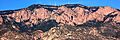
Sandia Crest from the west, with adjacent radio and TV towers
-
Sandia Crest with a wisp of snow, viewed from Sandia Resort & Casino, just north of Albuquerque
-
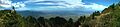
A panoramic view from Sandia Crest in August, centered to the southwest and showing Albuquerque in the distance
-
View from Sandia Peak, looking southwest
-
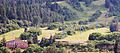
Sandia Peak Ski Area
-
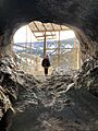
Sandia Cave
-
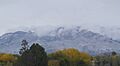
Early snow on the Sandias,
October 28, 2009
See also
 In Spanish: Sierra de Sandía para niños
