Cuba, New Mexico facts for kids
Quick facts for kids
Cuba, New Mexico
|
|
|---|---|
|
Village
|
|

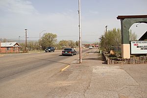
U.S. Route 550 in Cuba
|
|

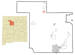
Location of Cuba, New Mexico
|
|
| Country | United States |
| State | New Mexico |
| County | Sandoval |
| Area | |
| • Total | 3.26 sq mi (8.45 km2) |
| • Land | 3.26 sq mi (8.45 km2) |
| • Water | 0.00 sq mi (0.00 km2) |
| Elevation | 6,884 ft (2,098 m) |
| Population
(2020)
|
|
| • Total | 628 |
| • Density | 192.40/sq mi (74.28/km2) |
| Time zone | UTC-7 (Mountain (MST)) |
| • Summer (DST) | UTC-6 (MDT) |
| ZIP code |
87013
|
| Area code(s) | 575 |
| FIPS code | 35-19150 |
| GNIS feature ID | 2413545 |
Cuba is a small village located in Sandoval County, New Mexico, in the United States. In 2020, about 628 people lived there. It is part of the larger Albuquerque area.
About Cuba
Cuba is found along U.S. Route 550, which is a busy road. Because of its location, you can find several motels, restaurants, and bars in the village.
A special event related to Cuba happened in 2005 and 2019. The National Christmas Tree, which is displayed in Washington, D.C., was chosen from the Santa Fe National Forest near Cuba.
Where is Cuba?
Cuba is a village that covers about 3.26 square miles (8.45 square kilometers) of land. There is no water area within the village limits.
Who Lives in Cuba?
| Historical population | |||
|---|---|---|---|
| Census | Pop. | %± | |
| 1970 | 415 | — | |
| 1980 | 609 | 46.7% | |
| 1990 | 760 | 24.8% | |
| 2000 | 590 | −22.4% | |
| 2010 | 731 | 23.9% | |
| 2020 | 628 | −14.1% | |
| U.S. Decennial Census | |||
In 2000, there were 590 people living in Cuba. These people lived in 222 households, and 152 of these were families. The village had about 465 people per square mile.
Many different groups of people make up the population of Cuba. About 60% of the people identified as Hispanic or Latino. The village is also home to many Native American residents.
About 33% of the people in Cuba were under 18 years old. The average age of people living in the village was 32 years old.
Weather in Cuba
| Climate data for Cuba, NM, 1981-2010 normals, extremes 1938-present | |||||||||||||
|---|---|---|---|---|---|---|---|---|---|---|---|---|---|
| Month | Jan | Feb | Mar | Apr | May | Jun | Jul | Aug | Sep | Oct | Nov | Dec | Year |
| Record high °F (°C) | 65 (18) |
68 (20) |
79 (26) |
82 (28) |
96 (36) |
99 (37) |
102 (39) |
96 (36) |
97 (36) |
88 (31) |
75 (24) |
74 (23) |
102 (39) |
| Mean daily maximum °F (°C) | 43.7 (6.5) |
46.7 (8.2) |
55.0 (12.8) |
63.8 (17.7) |
72.7 (22.6) |
82.6 (28.1) |
85.8 (29.9) |
82.9 (28.3) |
77.1 (25.1) |
65.5 (18.6) |
53.0 (11.7) |
43.4 (6.3) |
64.4 (18.0) |
| Mean daily minimum °F (°C) | 9.3 (−12.6) |
13.7 (−10.2) |
20.6 (−6.3) |
25.4 (−3.7) |
33.2 (0.7) |
39.9 (4.4) |
48.9 (9.4) |
48.5 (9.2) |
39.1 (3.9) |
27.5 (−2.5) |
17.1 (−8.3) |
10.5 (−11.9) |
27.8 (−2.3) |
| Record low °F (°C) | −37 (−38) |
−30 (−34) |
−14 (−26) |
−6 (−21) |
10 (−12) |
20 (−7) |
30 (−1) |
29 (−2) |
15 (−9) |
4 (−16) |
−30 (−34) |
−30 (−34) |
−37 (−38) |
| Average precipitation inches (mm) | 0.90 (23) |
0.76 (19) |
0.82 (21) |
0.73 (19) |
0.76 (19) |
0.74 (19) |
2.02 (51) |
2.28 (58) |
1.36 (35) |
1.08 (27) |
0.80 (20) |
0.67 (17) |
12.92 (328) |
| Average rainy days (≥ 0.01 in) | 3 | 3 | 4 | 3 | 4 | 4 | 8 | 10 | 6 | 4 | 3 | 3 | 55 |
| Source: [1] | |||||||||||||
Schools in the Area
The schools in Cuba are part of the Cuba Independent Schools district.
There are also several schools nearby that have a Cuba mailing address but are not actually inside the village. These schools are run by the Bureau of Indian Education (BIE) or are tribal schools connected to the BIE:
- Na'Neelzhin Ji'Olta School is a tribal school for grades K-8. It is located in Torreon.
- Ojo Encino Day School is a BIE school in Ojo Encino. It is about 27 miles (43 km) west of Cuba.
- Pueblo Pintado Community School is another BIE school, found in Pueblo Pintado.
Tseʼ Yiʼ Gai High School is also in Pueblo Pintado and is part of the Gallup-McKinley County Schools district. It also uses a Cuba postal address.
See also
 In Spanish: Cuba (Nuevo México) para niños
 | Emma Amos |
 | Edward Mitchell Bannister |
 | Larry D. Alexander |
 | Ernie Barnes |


