
Gallup, New Mexico facts for kids
Quick facts for kids
Gallup
|
||
|---|---|---|

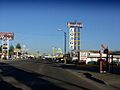
Motels and businesses in Gallup
|
||
|
||
| Nickname(s):
"Capital of the World"
|
||

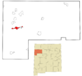
Location of Gallup in McKinley County and the state of New Mexico
|
||

Gallup
Location in the United States
|
||
| Country | United States | |
| State | New Mexico | |
| County | McKinley | |
| Founded | 1881 | |
| Area | ||
| • City | 20.19 sq mi (52.30 km2) | |
| • Land | 20.19 sq mi (52.29 km2) | |
| • Water | 0.003 sq mi (0.01 km2) | |
| Elevation | 6,647 ft (2,026 m) | |
| Population
(2020)
|
||
| • City | 21,899 | |
| • Density | 1,084.65/sq mi (418.78/km2) | |
| • Metro | 71,492 | |
| Time zone | UTC−7 (MST) | |
| • Summer (DST) | UTC−6 (MDT) | |
| ZIP codes |
87301, 87302, 87305, 87310, 87317, 87319, 87326, 87375
|
|
| Area code(s) | 505 | |
| FIPS code | 35-28460 | |
| GNIS feature ID | 2410562 | |
| Website | www.gallupnm.gov | |

Gallup is a city in McKinley County, New Mexico, United States. About 21,899 people lived there in 2020. A large part of its population is Native American. Many residents are from the Navajo, Hopi, and Zuni tribes.
Gallup is the main city of McKinley County. It is the biggest city between Flagstaff and Albuquerque. It sits along the famous U.S. Route 66. People often call Gallup the "Heart of Indian Country." This is because it is right next to the Navajo reservation. Many other tribes also have members living in Gallup.
The city is part of the Trails of the Ancients Byway. This is a special road that shows off ancient sites in New Mexico. Because of its rugged land, Gallup was a popular place for Hollywood Western movies in the 1940s and 1950s.
Contents
History of Gallup
Gallup was started in 1881. It was a stop for the Atlantic and Pacific Railroad. The city got its name from David Gallup. He was a paymaster for the railroad company.
Gallup's Location and Land
Gallup is in the western part of McKinley County. It is about 20 miles (32 km) east of the Arizona border. Interstate 40 goes through the north side of the city. You can get on or off at Exits 16, 20, and 22. This highway goes east to Albuquerque (about 138 miles or 222 km away). It goes west to Holbrook, Arizona (about 95 miles or 153 km away).
The old Historic U.S. Route 66 runs right through the middle of Gallup. U.S. Route 491 starts in Gallup at I-40. It goes north about 94 miles (151 km) to Shiprock and then into Colorado.
The city covers about 20.2 square miles (52.3 km²). Most of this is land. Gallup is in the valley of the Puerco River. This river flows southwest and joins the Little Colorado River in Holbrook.
Gallup's Climate
Gallup has a cool, dry climate. Summers are hot during the day. But because the city is high up and the air is dry, nights are cool. Sometimes, even in July, the temperature can drop to 31°F (–0.6°C). Most of the rain falls in summer from afternoon thunderstorms. Snow is common and can sometimes be heavy.
| Climate data for Gallup Municipal Airport, New Mexico, 1991–2020 normals, extremes 1973–present | |||||||||||||
|---|---|---|---|---|---|---|---|---|---|---|---|---|---|
| Month | Jan | Feb | Mar | Apr | May | Jun | Jul | Aug | Sep | Oct | Nov | Dec | Year |
| Record high °F (°C) | 68 (20) |
73 (23) |
80 (27) |
86 (30) |
95 (35) |
101 (38) |
101 (38) |
98 (37) |
96 (36) |
88 (31) |
78 (26) |
66 (19) |
101 (38) |
| Mean maximum °F (°C) | 57.5 (14.2) |
63.5 (17.5) |
71.8 (22.1) |
78.8 (26.0) |
87.1 (30.6) |
94.9 (34.9) |
96.2 (35.7) |
93.1 (33.9) |
88.8 (31.6) |
80.7 (27.1) |
69.7 (20.9) |
59.5 (15.3) |
97.1 (36.2) |
| Mean daily maximum °F (°C) | 45.4 (7.4) |
49.9 (9.9) |
58.5 (14.7) |
65.7 (18.7) |
75.0 (23.9) |
86.2 (30.1) |
88.8 (31.6) |
86.1 (30.1) |
79.9 (26.6) |
68.5 (20.3) |
55.8 (13.2) |
45.2 (7.3) |
67.1 (19.5) |
| Daily mean °F (°C) | 29.8 (−1.2) |
34.4 (1.3) |
40.6 (4.8) |
47.0 (8.3) |
55.6 (13.1) |
65.7 (18.7) |
71.7 (22.1) |
69.7 (20.9) |
62.2 (16.8) |
49.7 (9.8) |
38.0 (3.3) |
29.5 (−1.4) |
49.5 (9.7) |
| Mean daily minimum °F (°C) | 14.2 (−9.9) |
18.9 (−7.3) |
22.7 (−5.2) |
28.3 (−2.1) |
36.3 (2.4) |
45.1 (7.3) |
54.5 (12.5) |
53.3 (11.8) |
44.4 (6.9) |
31.0 (−0.6) |
20.2 (−6.6) |
13.9 (−10.1) |
31.9 (−0.1) |
| Mean minimum °F (°C) | −3.7 (−19.8) |
1.6 (−16.9) |
7.6 (−13.6) |
13.7 (−10.2) |
23.0 (−5.0) |
32.3 (0.2) |
43.3 (6.3) |
42.9 (6.1) |
28.9 (−1.7) |
15.5 (−9.2) |
4.1 (−15.5) |
−4.9 (−20.5) |
−8.4 (−22.4) |
| Record low °F (°C) | −20 (−29) |
−25 (−32) |
−10 (−23) |
6 (−14) |
12 (−11) |
23 (−5) |
31 (−1) |
35 (2) |
20 (−7) |
1 (−17) |
−26 (−32) |
−34 (−37) |
−34 (−37) |
| Average precipitation inches (mm) | 0.81 (21) |
0.71 (18) |
0.62 (16) |
0.46 (12) |
0.57 (14) |
0.36 (9.1) |
1.63 (41) |
1.92 (49) |
1.27 (32) |
0.92 (23) |
0.70 (18) |
0.73 (19) |
10.70 (272) |
| Average snowfall inches (cm) | 6.3 (16) |
5.9 (15) |
4.4 (11) |
2.3 (5.8) |
1.1 (2.8) |
0.0 (0.0) |
0.0 (0.0) |
0.0 (0.0) |
0.0 (0.0) |
1.5 (3.8) |
4.5 (11) |
7.8 (20) |
33.8 (86) |
| Average precipitation days (≥ 0.01 inch) | 6.1 | 6.0 | 5.4 | 4.2 | 4.2 | 2.8 | 10.2 | 10.7 | 7.0 | 5.5 | 4.6 | 5.8 | 72.5 |
| Average snowy days (≥ 0.1 inch) | 4.3 | 4.5 | 2.5 | 2.6 | 0.7 | 0.0 | 0.0 | 0.0 | 0.0 | 0.9 | 2.5 | 4.5 | 22.5 |
| Source: NOAA | |||||||||||||
People of Gallup
| Historical population | |||
|---|---|---|---|
| Census | Pop. | %± | |
| 1900 | 2,948 | — | |
| 1910 | 2,264 | −23.2% | |
| 1920 | 3,920 | 73.1% | |
| 1930 | 5,992 | 52.9% | |
| 1940 | 7,041 | 17.5% | |
| 1950 | 9,133 | 29.7% | |
| 1960 | 14,089 | 54.3% | |
| 1970 | 14,596 | 3.6% | |
| 1980 | 18,167 | 24.5% | |
| 1990 | 19,154 | 5.4% | |
| 2000 | 20,209 | 5.5% | |
| 2010 | 21,678 | 7.3% | |
| 2020 | 21,605 | −0.3% | |
| U.S. Decennial Census | |||
In 2000, there were 20,209 people living in Gallup. Many people in Gallup are Native American. About 43.8% of the city's population is Native American. There are also many White, Asian, and African American residents. About 31.7% of the people are Hispanic or Latino.
Gallup is close to Native American reservations. Because of this, and because many mines closed in the past, many families in Gallup have lower incomes.
Gallup also has a notable Palestinian-American population. This is unusual for a city of its size.
Arts and Culture in Gallup


The famous U.S. Route 66 goes through Gallup. The city's name is even in the song "(Get Your Kicks on) Route 66". Another major highway, US Highway 666, was renamed Route 491 in 2003.
Gallup has a fun downtown area at night. In the summer, you can see Indian dances. There are also art walks and small museums, like a Navajo code talker museum. Many murals around downtown show off the local culture and history.
Since Gallup is the biggest city between Flagstaff and Albuquerque, it has many interesting buildings and events. The historic El Rancho Hotel & Motel has hosted many famous movie stars. These include John Wayne, Ronald Reagan, Humphrey Bogart, and Katharine Hepburn.
The rugged land around Gallup was perfect for filming Westerns in the 1940s and 1950s. Actors and film crews would stay at the El Rancho Hotel. Movies filmed in Gallup include Billy the Kid (1930) and Superman (1978).
Gallup is sometimes called the "Indian Capital of the World." This is because it's in the middle of Native American lands. Many Navajo, Zuni, Hopi, and other tribes live here. Over a third of the city's people have Native American roots. This shows how much Native American cultures influence Gallup.
Education in Gallup
The local school district is called Gallup-McKinley County Public Schools. In the past, the Bureau of Indian Affairs (BIA) ran Manuelito Hall in Gallup. This was a dorm for Native American students who went to Gallup-McKinley schools. It closed in 1973.
Gallup's Transportation
Getting Around Gallup
- Gallup Municipal Airport is a public airport. It mainly handles private and charter flights. Its airport code is GUP.
Major Highways
- Interstate 40
- U.S. Route 491
Railroad Services
- Freight trains use the Southern Transcon line of the BNSF Railroad through Gallup.
- Amtrak's Southwest Chief passenger train stops at the Gallup train station.
Bus Services
- The Navajo Transit System offers bus services across the Navajo Nation. Gallup has routes to Fort Defiance, Arizona and Crystal, New Mexico.
- The Gallup Express provides local bus service in Gallup. It also connects to Zuni.
- A:shiwi Transit connects Zuni Pueblo and Black Rock with Gallup.
- Greyhound also has a stop in Gallup.
Famous People from Gallup
- Glenn L. Emmons – A banker and former commissioner of the BIA.
- Mike Everitt – A former Major League Baseball umpire.
- Sydney Freeland – A filmmaker.
- Chon Gallegos – A former NFL quarterback for the Oakland Raiders.
- Tony Genaro – A late actor.
- Carl Nelson Gorman – A Navajo code talker during World War II, artist, and professor.
- Arthur T. Hannett – A former mayor of Gallup and governor of New Mexico.
- Tito Jackson – A former member of The Jackson 5, who passed away in Gallup.
- Vernon Kerr – A scientist and member of the New Mexico House of Representatives.
- Lealand McSpadden – A racing driver.
- Hiroshi H. Miyamura – A Medal of Honor recipient from the Korean War.
- Eric-Paul Riege – A modern artist.
- Carolyn S. Shoemaker – An astronomer who helped discover Comet Shoemaker-Levy 9.
- Sunshine Sykes – A lawyer and judge.
Images for kids
-
Motels and businesses in Gallup
-

Flag of Gallup, New Mexico
-
Location of Gallup in McKinley County and the state of New Mexico
-
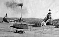
American Coal Company mine and plant, Gallup, circa 1920: Early coal mining here supplied the railroad's steam locomotives.
-
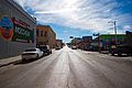
South 3rd Street
-

Solar farm in Gallup
See also
 In Spanish: Gallup para niños
