
Trail of the Ancients Scenic Byway (New Mexico) facts for kids
Quick facts for kids Trail of the Ancients Scenic Byway |
|
|---|---|

|
The Trail of the Ancients is a special road in New Mexico that takes you to amazing old places. These places show how people lived long, long ago. You can learn about the Ancestral Puebloans, Navajo, Ute, and Apache peoples.
The trail also features cool natural spots. You'll see deep canyons, rocks formed by volcanoes, and tall sandstone hills. Many of these areas are beautiful and great for outdoor fun.
Contents
- Discovering Ancient Lives
- Chaco Culture National Historical Park
- Crownpoint: Navajo Rugs
- Casamero Pueblo: Ancient Outlier
- Grants Volcanic Sites: Lava and Ice
- El Morro: The Great Rock
- Zuni Pueblo: Seven Cities of Gold
- Gallup: Code Talkers and Crafts
- Trading Posts: Navajo Weaving
- Farmington: Rivers and Recreation
- Aztec Ruins National Monument: Another Chacoan Site
- Badlands Recreation Areas: Unique Landscapes
- Beklabito: Navajo Scenery
- History of the Byway
- Gallery
Discovering Ancient Lives

The Trail of the Ancients helps us understand people who lived here thousands of years ago. These were hunter-gatherers who found their food in nature. Later, the Ancestral Puebloans built large communities between about 850 and 1250 A.D. Today's Hopi, Zuni, and Rio Grande Pueblo tribes are their descendants.
About 500 years ago, the Navajo arrived from Canada. Other Native American groups like the Utes and Apaches also lived here.
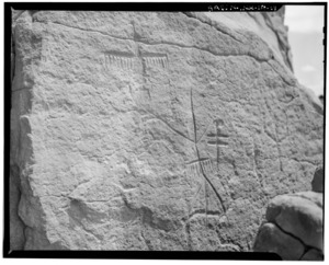
These early people left clues about their lives. You can see old village ruins, broken pottery, and tools. They also drew pictures on rocks called pictographs and carved designs called petroglyphs. The land itself is amazing, with huge sandstone shapes, wide deserts, and cool rock formations.
A very important place on the trail is Chaco Canyon. It was a major center for the Pueblo people from 850 to 1250 A.D. Other key spots are El Morro National Monument and El Malpais National Monument.
Much of this area in northwestern New Mexico belongs to the Navajo Nation. The trail follows several roads, including U.S. Route 64, U.S. Route 550, NM 57, NM 122, and other local roads.
Chaco Culture National Historical Park
Chaco Culture National Historical Park is a UNESCO World Heritage Site. This means it's a very important place for everyone in the world! People lived in Chaco Canyon between 850 and 1250 A.D. It's the main point and starting place for the byway.
Chaco is in a quiet, remote area, and the road to get there can be rough. To find it, follow signs from U.S. Route 550, then turn onto County Road 7900. At the park, you'll find a visitor center, six big ancient sites, and trails to explore even more.
From Chaco Park, drive south on NM 57 to NM 371. Then head south to Crownpoint. This town is famous for its monthly auction where you can see and buy beautiful Navajo rugs.
Casamero Pueblo: Ancient Outlier
Keep going south on NM 371. Turn right onto Navajo Road 48, then onto McKinley County Road 19. This road leads you to the Casamero Pueblo. This pueblo was a smaller village connected to the main Chacoan site between about 1000 and 1125 A.D.
Grants Volcanic Sites: Lava and Ice

Travel south on McKinley County Road 19 to NM 122. Turn left and drive to Grants. Here, you can visit the New Mexico Mining Museum.
Continue on NM 122 to NM 117 and drive south to El Malpais National Monument. This area was formed by lava flows about 3,000 years ago!
Go back to Grants and from NM 122, take NM 53 south. You'll find the Ice Cave and the Zuni-Bandera volcanic field. This area has a "Chain of Craters," which are hills shaped like cones from old volcanoes.
El Morro: The Great Rock
Drive west on NM 53 to El Morro National Monument. This is a huge rock that looks like a giant ship on the horizon. Many travelers from long ago carved their names and messages into its sides.
Zuni Pueblo: Seven Cities of Gold

Continue west on NM 53 to the Zuni Pueblo. This pueblo had six original villages. The explorer Francisco Vázquez de Coronado came here looking for the famous "Seven Cities of Gold" long ago.
Gallup: Code Talkers and Crafts
Gallup is north on NM 602. In Gallup, you can see a mural honoring the Navajo Code Talkers from World War II. These brave soldiers used their language as a secret code. You can also find Native American crafts, a Visitor's Center, and the historic El Rancho Hotel & Motel.
North of Gallup, in Newcomb on U.S. Route 491, you'll find two trading posts: Two Grey Hills and Toadlena. About 1,500 Navajo people live nearby. Some of them sell their beautiful handmade rugs at these trading posts.
Farmington: Rivers and Recreation
Farmington is north on U.S. Route 64. A lot of New Mexico's surface water flows through the rivers in this area. Farmington has fun trails for recreation and a museum called the Farmington Museum.
Aztec Ruins National Monument: Another Chacoan Site
Near Bloomfield, east of U.S. 64, are the Aztec Ruins National Monument. These are two ancient pueblo ruins that were also connected to the Chacoan Canyon site.
Badlands Recreation Areas: Unique Landscapes
South of Bloomfield, off of NM 371, you'll find the unique "badlands" of New Mexico. These include the Bisti Wilderness Area, De-Na-Zin Wilderness Area, and Angel Peak Scenic Area. They have amazing, unusual rock formations.
Beklabito (also spelled Beclabito) is a Navajo community located west on U.S. 64. The scenery here is beautiful, with traditional Navajo hogans (round homes), red sandstone rocks, and hills striped with yellow and gray.
History of the Byway
The Trail of the Ancients Scenic Byway became an official New Mexico Scenic Byway sometime after July 31, 1998, and was fully recognized by 2013.
Gallery
-
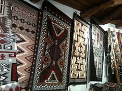
Examples of Navajo rugs
-
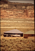
Examples of Navajo hogans
-
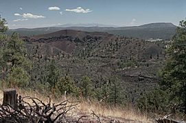
Bandera Volcano


