
Bisti/De-Na-Zin Wilderness facts for kids
Quick facts for kids Bisti/De-Na-Zin Wilderness |
|
|---|---|
|
IUCN Category Ib (Wilderness Area)
|
|

Bisti/De-Na-Zin Wilderness
Location in the United States

Bisti/De-Na-Zin Wilderness
Location in New Mexico
|
|
| Location | San Juan County, New Mexico, U.S. |
| Nearest city | Huerfano, New Mexico |
| Area | 45,000 acres (18,000 ha) |
| Established | 1984 |
| Governing body | Bureau of Land Management |
| Website | Bisti/De-Na-Zin Wilderness |


The Bisti/De-Na-Zin Wilderness is a special wild area in New Mexico, USA. It covers about 45,000 acres (18,211 hectares). This amazing place was created in 1984. It is known for its unique badlands, which are lands shaped by strong erosion. The Bureau of Land Management takes care of most of this wilderness. Some small parts are owned by the Navajo Nation. In 2019, the wilderness area grew by about 2,250 acres.
The name Bisti comes from the Navajo language word Bistahí. It means "among the adobe formations." De-Na-Zin comes from the Navajo word Dééł Náázíní. This means "Standing Crane." Ancient rock carvings, called petroglyphs, of cranes have been found nearby. The wilderness is part of the Trails of the Ancients Byway. This is a special road that shows off ancient sites in New Mexico.
Contents
Ancient History of the Land
This area was once a huge river delta about 70 million years ago. It was next to an ancient sea called the Western Interior Seaway. This sea covered much of New Mexico. Over time, layers of sand and mud built up from the moving water. Swamps and ponds also left behind lots of plant material. This plant material later turned into a type of coal called lignite.
At one point, a volcano erupted and covered the area with ash. As the water slowly went away, prehistoric animals lived among the lush plants. When the water was gone, it left behind a thick layer of rock. This included sandstone, mudstone, shale, and coal. This layer was about 1,400 feet (427 meters) thick.
How the Badlands Formed
About 25 million years ago, the land began to lift up. This created the Colorado Plateau. Then, about 6,000 years ago, the last ice age ended. Melting glaciers helped uncover fossils and petrified wood. The water and wind also carved the rock into the amazing shapes you see today. These shapes are called hoodoos.
When you visit Bisti/De-Na-Zin Wilderness, you walk from sandy desert into a world of gray, black, red, and purple rocks. The badlands were formed as softer layers of rock wore away. This left behind harder layers of volcanic ash, and the Fruitland Formation and Kirtland Shale rocks. The western part of the wilderness is mostly Fruitland Formation. The eastern part shows the Kirtland Shale.
Water often seeped into the ash layers when the area was deep underground. This water left behind lime deposits. These deposits eventually formed hard limestone tubes. As the softer ash wore away, these tubes became exposed. Many of the gray hoodoos in Bisti have limestone caps.
Ash wears away very quickly and does not hold water well. This is why not many plants grow here. The lignite beds, which formed from ancient swamps, are now exposed. These beds are where most of the petrified wood and fossils are found. The fossils here show us what freshwater life was like 70 million years ago.
Colors of the Wilderness
There was also a lot of coal in the wilderness. Much of this coal burned in an ancient fire that lasted for centuries. The heat from this fire changed the clay above the coal. It turned into red "clinkers." These look like tiny pieces of pottery or brick. They can be pale, bright red, or even crimson. They are called "clinkers" because of the sound they make when you walk on them. The ash, lignite beds, and clinkers give the wilderness its unique gray, black, and red colors.
On the eastern side of the wilderness, you can see layers of shale. These layers include the K/T boundary layer. This is a special layer of rock that shows the time when dinosaurs died out. It is one of the few places in the world where you can see this layer. This eastern side has more sand and fewer hoodoos.
Erosion is the main process that shaped this landscape. The plains around the wilderness are about 6,500 feet (1,981 meters) above sea level. The badlands are 200 to 400 feet (61 to 122 meters) lower. The highest points in the wilderness are grassy mesas. From these points, it looks like you are looking across a flat grass plain. This is because the lower, carved-out areas are hidden. It shows how much wind and water have carved away the land over time.
Where hard rocks sit on top of softer ash, hoodoos have formed. These pillars and pedestals exist because everything around and below them has been removed by wind and water.
Humans have lived in this area for a very long time, since about 10,000 BC. The area has many ancient sites from the Chacoan people. Part of the prehistoric Great North Road is also here. This road connected major Chacoan sites in the San Juan Basin.
Wildlife in Bisti/De-Na-Zin
You can find a variety of animals living in the Bisti/De-Na-Zin Wilderness. Some of these include cottontail rabbits, coyotes, badgers, and prairie dogs. Many different birds also live here. These include pinyon jays, ravens, quail, doves, ferruginous hawks, prairie falcons, and golden eagles. You might also see lizards, snakes, tarantulas, and scorpions.
Things to Do
The Bisti/De-Na-Zin Wilderness is a great place for outdoor activities. You can go hiking and camping here. It's also a wonderful spot for watching wildlife and taking photos. Horseback riding is another popular activity. Remember, campfires are not allowed in the wilderness to protect the area.
Images for kids
-
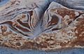
Bisti Abstract
-
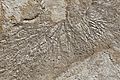
Bisti Badlands. The cause of this pattern is unknown.
.jpg)
.jpg)
