San Juan County, New Mexico facts for kids
Quick facts for kids
San Juan County
|
||
|---|---|---|
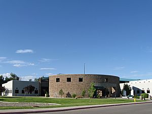
San Juan County Administration Building in Aztec
|
||
|
||
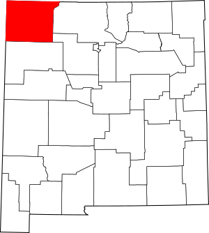
Location within the U.S. state of New Mexico
|
||
 New Mexico's location within the U.S. |
||
| Country | ||
| State | ||
| Founded | February 24, 1887 | |
| Named for | San Juan River | |
| Seat | Aztec | |
| Largest city | Farmington | |
| Area | ||
| • Total | 5,538 sq mi (14,340 km2) | |
| • Land | 5,513 sq mi (14,280 km2) | |
| • Water | 25 sq mi (60 km2) 0.5%% | |
| Population
(2020)
|
||
| • Total | 121,661 | |
| • Density | 24/sq mi (9/km2) | |
| Time zone | UTC−7 (Mountain) | |
| • Summer (DST) | UTC−6 (MDT) | |
| Congressional district | 3rd | |
San Juan County is a county located in the state of New Mexico. It was created in 1887. As of the 2020 census, about 121,661 people live here. This makes it the fifth-most populated county in New Mexico. The main town, or county seat, is Aztec.
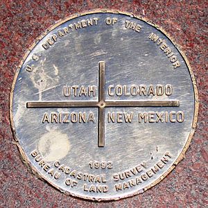
San Juan County is part of the Farmington, New Mexico, area. It is in the northwest corner of New Mexico. This county also includes the New Mexico part of the famous Four Corners landmark. The Four Corners is where the borders of four U.S. states meet: New Mexico, Arizona, Utah, and Colorado.
Contents
Geography of San Juan County
San Juan County covers a total area of about 5,538 square miles. Most of this area, about 5,513 square miles, is land. The rest, about 25 square miles, is water. A large part of the county's land, about 63.4 percent, is made up of Indian reservations. The Navajo Nation covers about 60.45% of the land. The Ute Mountain Ute Tribe Reservation covers another 2.93%.
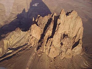
The county has many interesting natural features. Three important rivers flow through it: the San Juan, Animas, and La Plata rivers. You can also find the Chuska Mountains and the amazing Shiprock Pinnacle to the west. The area has volcanic structures, tall flat-topped hills called buttes and mesas, and unique badlands. There are also fertile river valleys perfect for farming.
Neighboring Counties
San Juan County shares its borders with several other counties:
- Rio Arriba County to the east
- Sandoval County to the southeast
- McKinley County to the south
- Apache County, Arizona to the west
- San Juan County, Utah to the northwest
- Montezuma County, Colorado to the north
- La Plata County, Colorado to the north
- Archuleta County, Colorado to the northeast
Protected Natural Areas
San Juan County is home to some important national protected areas:
- Aztec Ruins National Monument: This site protects ancient Pueblo structures.
- Chaco Culture National Historical Park (part): A part of this park, known for its ancient Pueblo great houses, is in San Juan County.
Main Roads and Highways
Several major roads help people travel through San Juan County:
 U.S. Route 64
 U.S. Route 491 (This road used to be called U.S. Route 666.)
 U.S. Route 550
 New Mexico State Road 170
 New Mexico State Road 371
 New Mexico State Road 511
 New Mexico State Road 597 (This road connects to the Four Corners Monument.)
People of San Juan County
In 2010, there were about 130,044 people living in San Juan County. The population density was about 23.6 people per square mile.
The people living in the county come from many different backgrounds:
- About 51.6% were White.
- About 36.6% were American Indian.
- About 7.3% were from other races.
- About 3.5% were from two or more races.
- About 0.6% were Black or African American.
- About 0.4% were Asian.
- About 0.1% were Pacific Islander.
People of Hispanic or Latino origin made up about 19.1% of the population.
Some of the largest ancestry groups in the county include:
- Navajo (34.8%)
- English (15.0%)
- Mexican (10.7%)
- German (9.1%)
- Irish (5.9%)
- Spanish (4.4%)
The average age of people in the county was 33.0 years old. The average household had 2.89 people. The average family had 3.38 people.
Towns and Communities
San Juan County has several cities and many smaller communities.
Cities
- Aztec (the county seat)
- Bloomfield
- Kirtland
- Farmington (the largest city)
Census-Designated Places (CDPs)
CDPs are areas that are like towns but are not officially incorporated as cities.
- Angustura
- Beclabito
- Blanco
- Cedar Hill
- Center Point
- Crystal
- Flora Vista
- La Boca
- La Plata
- Lake Valley
- Lee Acres
- Nageezi
- Napi Headquarters
- Naschitti
- Navajo Dam
- Nenahnezad
- Newcomb
- North Light Plant
- Ojo Amarillo
- Sanostee
- Sheep Springs
- Shiprock
- Spencerville
- Totah Vista
- Turley
- Upper Fruitland
- Waterflow
- West Hammond
- White Rock
- Young Place
Other Communities
Education in San Juan County
Students in San Juan County attend schools run by different school districts:
- Aztec Municipal Schools
- Bloomfield Municipal Schools
- Central Consolidated Schools
- Farmington Municipal Schools
See also
 In Spanish: Condado de San Juan (Nuevo México) para niños
 | Anna J. Cooper |
 | Mary McLeod Bethune |
 | Lillie Mae Bradford |


