La Plata County, Colorado facts for kids
Quick facts for kids
La Plata County
|
|||||
|---|---|---|---|---|---|

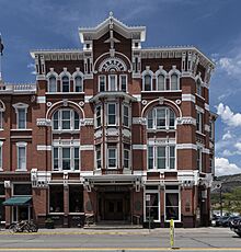
Strater Hotel, opened in 1888 during a mining boom in Durango.
|
|||||
|
|||||

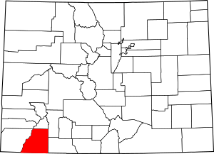
Location within the U.S. state of Colorado
|
|||||
 Colorado's location within the U.S. |
|||||
| Country | |||||
| State | |||||
| Founded | February 10, 1874 | ||||
| Named for | Spanish for "the silver" | ||||
| Seat | Durango | ||||
| Largest city | Durango | ||||
| Area | |||||
| • Total | 1,700 sq mi (4,000 km2) | ||||
| • Land | 1,692 sq mi (4,380 km2) | ||||
| • Water | 7.6 sq mi (20 km2) 0.4%% | ||||
| Population
(2020)
|
|||||
| • Total | 55,638 | ||||
| • Density | 33/sq mi (13/km2) | ||||
| Time zone | UTC−7 (Mountain) | ||||
| • Summer (DST) | UTC−6 (MDT) | ||||
| Congressional district | 3rd | ||||
La Plata County is a county located in the U.S. state of Colorado. In 2020, about 55,638 people lived here. The main city, or county seat, is Durango.
The county was named after the La Plata River and the La Plata Mountains. "La Plata" means "the silver" in Spanish. This county is also home to the Durango Rock Shelters Archeology Site. This site is important for studying the ancient Anasazi culture, specifically the Basketmaker II period.
Contents
Geography of La Plata County
La Plata County covers a total area of about 1,700 square miles (4,400 km²). Most of this area, about 1,692 square miles (4,382 km²), is land. Only a small part, about 7.6 square miles (20 km²), is water.
Neighboring Counties
La Plata County shares its borders with several other counties:
- San Juan County to the north
- Hinsdale County to the northeast
- Archuleta County to the east
- San Juan County, New Mexico to the south
- Montezuma County to the west
- Dolores County to the northwest
Main Roads and Highways
Several important roads run through La Plata County, helping people travel around. These include:
 U.S. Highway 160
 U.S. Highway 550
 State Highway 140
 State Highway 151
 State Highway 172
Population and People
| Historical population | |||
|---|---|---|---|
| Census | Pop. | %± | |
| 1880 | 1,110 | — | |
| 1890 | 5,509 | 396.3% | |
| 1900 | 7,016 | 27.4% | |
| 1910 | 10,812 | 54.1% | |
| 1920 | 11,218 | 3.8% | |
| 1930 | 12,975 | 15.7% | |
| 1940 | 15,494 | 19.4% | |
| 1950 | 14,880 | −4.0% | |
| 1960 | 19,225 | 29.2% | |
| 1970 | 19,199 | −0.1% | |
| 1980 | 27,424 | 42.8% | |
| 1990 | 32,284 | 17.7% | |
| 2000 | 43,941 | 36.1% | |
| 2010 | 51,334 | 16.8% | |
| 2020 | 55,638 | 8.4% | |
| 2023 (est.) | 56,407 | 9.9% | |
| U.S. Decennial Census 1790-1960 1900-1990 1990-2000 2010-2020 |
|||
The population of La Plata County has grown a lot over the years. In 1880, only 1,110 people lived here. By 2020, the population had grown to 55,638 people. This shows how the county has developed over time.
Cities and Towns
La Plata County has several communities, from a main city to smaller towns and villages.
City
- Durango is the largest city and the county seat.
Towns
Census-Designated Places
These are areas that are like towns but are not officially incorporated as cities or towns.
Other Communities
Many smaller, unincorporated communities are also part of La Plata County.
Historic Ghost Towns
Some places in La Plata County were once busy towns but are now abandoned. These are called ghost towns.
- Greysill Mines
- La Plata
- Parrott City
Fun and Outdoor Activities
La Plata County offers many places for outdoor fun and adventure.
National Forests and Wilderness Areas
- San Juan National Forest is a huge forest perfect for hiking and camping.
- Weminuche Wilderness is a protected area where nature is left wild and untouched.
Historic Sites
- The Durango-Silverton Narrow-Gauge Railroad National Historic District is a famous old train line. It offers scenic rides through the mountains.
Trails for Exploring
- The Colorado Trail is a long trail for hiking and biking across Colorado.
- The Old Spanish National Historic Trail follows an old trade route from the past.
Biking Routes
- The Great Parks Bicycle Route is a special path for cyclists.
Scenic Drives
- The San Juan Skyway National Scenic Byway is a beautiful road for driving. It offers amazing views of the mountains and landscapes.
Education in La Plata County
Students in La Plata County attend schools in several public school districts.
Public Education
Durango School District 9-R
This district serves students in and around Durango.
- Elementary Schools
- Animas Valley Elementary School
- Florida Mesa Elementary School
- Fort Lewis Mesa Elementary School
- Needham Elementary School
- Park Elementary School
- Riverview Elementary School
- Sunnyside Elementary School
- Middle Schools
- Escalante Middle School
- Miller Middle School
- High Schools
- Durango High School
- Durango Big Picture High School
Bayfield School District
This district serves students in the Bayfield area.
- Elementary Schools
- Bayfield Primary School
- Bayfield Intermediate School
- Middle School
- Bayfield Middle School
- High School
- Bayfield High School
Ignacio School District 11-JT
This district serves students in the Ignacio area.
- Elementary School
- Ignacio Elementary School
- Middle School
- Ignacio Middle School
- High School
- Ignacio High School
See also
 In Spanish: Condado de La Plata para niños
 | Aaron Henry |
 | T. R. M. Howard |
 | Jesse Jackson |


