La Plata River (San Juan River tributary) facts for kids
Quick facts for kids La Plata River |
|
|---|---|

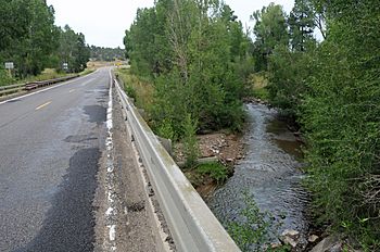
The river as it passes under Colorado State Highway 140 near Breen
|
|
| Physical characteristics | |
| Main source | 37°27′23″N 108°02′04″W / 37.45639°N 108.03444°W |
| River mouth | Confluence with San Juan 5,213 ft (1,589 m) 36°44′10″N 108°15′06″W / 36.73611°N 108.25167°W |
| Basin features | |
| Progression | San Juan—Colorado |
The La Plata River is a small river in the United States. It flows for about 70-mile (110 km) (113 kilometers). This river is a branch, or tributary, of the San Juan River.
The La Plata River starts in Colorado and flows into New Mexico. It passes through La Plata County in Colorado and San Juan County in New Mexico.
Where the La Plata River Begins and Ends
The La Plata River begins in the La Plata Mountains of southwestern Colorado. Its starting point is near Snow Storm Peak. This is about 35 miles (56 kilometers) north of the New Mexico state line.
The river then flows south. It joins the San Juan River near the city of Farmington, New Mexico. This meeting point is about 19 miles (31 kilometers) south of the Colorado state line.
What the Name "La Plata" Means
The name "La Plata" comes from the Spanish language and means "The Silver." This might be because of silver mining in the nearby mountains.
The Navajo people also have a name for the river. In their language, Tsé Dogoi Nlini means "flowing over projecting rock." This name describes how the river moves over the land.

See also
 In Spanish: Río La Plata para niños
 | Lonnie Johnson |
 | Granville Woods |
 | Lewis Howard Latimer |
 | James West |

