Farmington, New Mexico facts for kids
Quick facts for kids
Farmington
Tóta' (Navajo)
|
||
|---|---|---|
|
City
|
||
| City of Farmington | ||
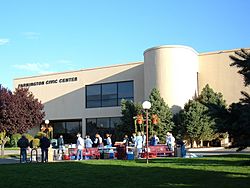
Farmington Civic Center
|
||
|
||
| Nickname(s):
Baseball Town, U.S.A.
|
||
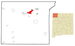
Location of Farmington in New Mexico
|
||
| Country | United States | |
| State | New Mexico | |
| County | San Juan | |
| Founded | 1901 | |
| Area | ||
| • Total | 34.95 sq mi (90.51 km2) | |
| • Land | 34.46 sq mi (89.25 km2) | |
| • Water | 0.49 sq mi (1.26 km2) | |
| Elevation | 5,473 ft (1,668 m) | |
| Population
(2020)
|
||
| • Total | 46,624 | |
| • Density | 1,352.95/sq mi (522.38/km2) | |
| Time zone | UTC−7 (Mountain Time Zone) | |
| • Summer (DST) | UTC−6 (Mountain Daylight Time) | |
| ZIP codes |
87401, 87402, 87499
|
|
| Area code(s) | 505 | |
| FIPS code | 35-25800 | |
| GNIS feature ID | 2410487 | |
| Website | www.fmtn.org | |
Farmington (called Tóta' in Navajo) is a city in San Juan County, New Mexico. In 2020, about 46,624 people lived there. Farmington and the area around it form one of New Mexico's main city regions.
Farmington is special because three rivers meet there: the San Juan River, the Animas River, and the La Plata River. It is also part of the Colorado Plateau. Farmington is the biggest city in San Juan County, which is one of the largest counties in the United States. It covers about 5,538 square miles.
The city is a major business center for northwestern New Mexico and the Four Corners region. This is where the corners of four states meet. Several important highways meet in Farmington, like U.S. Highway 64 and New Mexico Highway 371. It is also on the Trails of the Ancients Byway, a special scenic road.
Farmington's main industries are producing oil, natural gas, and coal. It is also a big shopping area. Near Farmington, the Navajo Mine digs for coal. This coal is used to power the nearby Four Corners Generating Station, which makes electric power for many homes.
Contents
History of Farmington
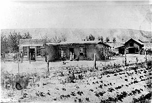
The area where Farmington is today was first settled by the Ancestral Pueblo people around the 600s. You can still visit their ancient ruins at Salmon Ruins and Aztec Ruins. After the Ancestral Puebloans left, the Navajos, Jicarilla Apaches, and Utes moved into the area. The Navajos called a key part of this region Tóta', which means "where three rivers meet."
Even though Spanish and American explorers looked for minerals here, there were few permanent towns. In 1868, the Navajo Nation was created, covering the western half of San Juan County. A few years later, the U.S. government offered land in the rest of San Juan County to the Jicarilla Apache, but they did not want it. So, the area was opened for new settlers, and many people moved in from Southern Colorado. The area was first called "Junction City" because of the three rivers meeting.
In 1901, the town officially became a city and was named Farmington. It had 548 people then. By 1905, a railroad connected Farmington to Durango, Colorado. This helped the city grow and brought more business. The railroad line was later removed in 1969. In the 1920s, people started investing in natural gas and oil in the area. Production really grew in the 1950s.
A new road connecting Farmington to U.S. Route 66 and Albuquerque was built in the 1940s. Also, a big natural gas pipeline was built in 1953. These changes helped Farmington's population grow a lot. However, because the city depended so much on the energy industry, its economy was affected by changes in oil prices in the 1970s. This led the city to try and develop other types of businesses.
In 1967, a special underground nuclear test called Project Gasbuggy happened about 50 miles east of Farmington. It was a test to see if nuclear explosions could help get more natural gas from the ground.
Farmington has also been part of efforts to ensure fair treatment for all people. In 1950, many people in Farmington reported seeing large, fast-moving saucers in the sky. This was a famous UFO sighting.
Farmington's Geography and Climate
Farmington covers about 32 square miles. Most of this area is land, with a small part being water.
Climate in Farmington
Farmington has a semi-arid climate. This means it is usually dry. Even though the city is high up (about 5,473 feet above sea level), summers can be hot and winters can be cold. There isn't much rain or snow throughout the year. On average, Farmington gets about 12.3 inches of snow each year.
| Climate data for Farmington, New Mexico, 1991–2020 normals, extremes 1978–present | |||||||||||||
|---|---|---|---|---|---|---|---|---|---|---|---|---|---|
| Month | Jan | Feb | Mar | Apr | May | Jun | Jul | Aug | Sep | Oct | Nov | Dec | Year |
| Record high °F (°C) | 66 (19) |
70 (21) |
82 (28) |
86 (30) |
97 (36) |
101 (38) |
103 (39) |
99 (37) |
98 (37) |
89 (32) |
79 (26) |
67 (19) |
103 (39) |
| Mean maximum °F (°C) | 54.7 (12.6) |
61.6 (16.4) |
72.8 (22.7) |
80.3 (26.8) |
88.2 (31.2) |
95.9 (35.5) |
97.8 (36.6) |
94.9 (34.9) |
90.4 (32.4) |
82.1 (27.8) |
68.7 (20.4) |
56.6 (13.7) |
98.4 (36.9) |
| Mean daily maximum °F (°C) | 41.1 (5.1) |
48.0 (8.9) |
57.7 (14.3) |
65.4 (18.6) |
75.0 (23.9) |
86.4 (30.2) |
90.2 (32.3) |
87.2 (30.7) |
80.0 (26.7) |
67.5 (19.7) |
53.3 (11.8) |
41.7 (5.4) |
66.1 (19.0) |
| Daily mean °F (°C) | 30.6 (−0.8) |
36.3 (2.4) |
44.1 (6.7) |
50.9 (10.5) |
60.2 (15.7) |
70.5 (21.4) |
75.8 (24.3) |
73.5 (23.1) |
66.0 (18.9) |
53.8 (12.1) |
41.1 (5.1) |
31.2 (−0.4) |
52.8 (11.6) |
| Mean daily minimum °F (°C) | 20.0 (−6.7) |
24.5 (−4.2) |
30.6 (−0.8) |
36.5 (2.5) |
45.4 (7.4) |
54.6 (12.6) |
61.3 (16.3) |
59.8 (15.4) |
52.0 (11.1) |
40.1 (4.5) |
28.8 (−1.8) |
20.8 (−6.2) |
39.5 (4.2) |
| Mean minimum °F (°C) | 6.0 (−14.4) |
10.5 (−11.9) |
16.8 (−8.4) |
23.7 (−4.6) |
32.2 (0.1) |
42.2 (5.7) |
52.9 (11.6) |
52.1 (11.2) |
37.8 (3.2) |
24.3 (−4.3) |
12.5 (−10.8) |
5.4 (−14.8) |
2.2 (−16.6) |
| Record low °F (°C) | −8 (−22) |
−14 (−26) |
3 (−16) |
16 (−9) |
23 (−5) |
32 (0) |
43 (6) |
41 (5) |
28 (−2) |
5 (−15) |
4 (−16) |
−16 (−27) |
−16 (−27) |
| Average precipitation inches (mm) | 0.54 (14) |
0.52 (13) |
0.59 (15) |
0.62 (16) |
0.60 (15) |
0.26 (6.6) |
0.77 (20) |
0.98 (25) |
1.09 (28) |
0.84 (21) |
0.59 (15) |
0.55 (14) |
7.95 (202.6) |
| Average snowfall inches (cm) | 2.2 (5.6) |
2.0 (5.1) |
0.9 (2.3) |
0.3 (0.76) |
0.0 (0.0) |
0.0 (0.0) |
0.0 (0.0) |
0.0 (0.0) |
0.0 (0.0) |
0.5 (1.3) |
0.7 (1.8) |
2.0 (5.1) |
8.6 (21.96) |
| Average precipitation days (≥ 0.01 in) | 5.3 | 5.1 | 4.7 | 4.4 | 4.1 | 2.5 | 6.9 | 7.1 | 5.8 | 5.6 | 4.6 | 5.4 | 61.5 |
| Average snowy days (≥ 0.1 in) | 2.0 | 1.9 | 0.7 | 0.3 | 0.0 | 0.0 | 0.0 | 0.0 | 0.0 | 0.3 | 0.7 | 2.7 | 8.6 |
| Source 1: NOAA | |||||||||||||
| Source 2: National Weather Service | |||||||||||||
People of Farmington
| Historical population | |||
|---|---|---|---|
| Census | Pop. | %± | |
| 1910 | 785 | — | |
| 1920 | 728 | −7.3% | |
| 1930 | 1,350 | 85.4% | |
| 1940 | 2,161 | 60.1% | |
| 1950 | 3,637 | 68.3% | |
| 1960 | 23,786 | 554.0% | |
| 1970 | 21,979 | −7.6% | |
| 1980 | 31,222 | 42.1% | |
| 1990 | 33,997 | 8.9% | |
| 2000 | 37,844 | 11.3% | |
| 2010 | 45,877 | 21.2% | |
| 2020 | 46,624 | 1.6% | |
| U.S. Decennial Census | |||
In 2010, Farmington had about 45,895 people and 17,548 homes. Most people were White (62.8%), and a large part were Native American (22.2%). About 22.4% of the population was Hispanic or Latino.
About one-third of homes had children under 18 living there. Many homes (49%) were married couples. The average family had about 3 people.
Fun Things to Do in Farmington
Farmington is known for its love of baseball! Since 1965, it has hosted the Connie Mack World Series baseball tournament every August. This big event takes place at Ricketts Park. Teams from all over the United States, including Puerto Rico, come to play. Players in the Connie Mack league are usually 16 to 18 years old.
The city also holds a "Riverfest" once a year. This festival celebrates the local rivers with music, art, food, and entertainment. You can join a 10K or 5K run, walk along the riverside trails, or even go on river raft rides.
If you like golf, Piñon Hills Golf Course in Farmington is a great place to play. It's known as one of the best public golf courses in the United States.
Fishing is also very popular in Farmington. You can go fishing in the San Juan River, Navajo Lake, Lake Farmington, Morgan Lake, the Animas River, Jackson Lake, and Cutter Dam.
Education in Farmington
The Farmington Municipal School District teaches over 10,000 students from kindergarten through 12th grade. There are 20 schools in the district.
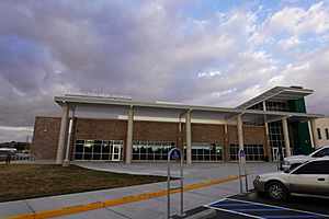
Farmington has several high schools:
- Farmington High School
- Piedra Vista High School
- Rocinante High School
- San Juan College High School
There are also four middle schools: Heights, Hermosa, Mesa View, and Tibbetts. The New Mexico School for the Deaf has a preschool in Farmington. Navajo Preparatory School is a special school for Native American students.
There are also private schools, like Sacred Heart School, which was started in 1910.
San Juan College is a public two-year college. In Fall 2021, almost 6,000 students were taking classes there.
The Farmington Public Library moved into a new building in 2003. It has about 200,000 items for people to borrow.
Getting Around Farmington
Air Travel
Farmington is served by the Four Corners Regional Airport.
Major Roads

- U.S. Highway 64 is the main road that goes east and west through Farmington.
- New Mexico State Road 170 goes north from U.S. Highway 64 to the Colorado state line.
- New Mexico State Road 371 goes south from U.S. Highway 64 to Interstate 40. This road mostly goes through the Navajo Indian reservation.
- New Mexico State Road 516 connects Farmington to U.S. Highway 550 in Aztec.
- U.S. Highway 550 doesn't go through Farmington itself, but it's nearby. It's an important road to connect to central New Mexico, Interstate 25, and cities like Albuquerque and Santa Fe.
Bus Services
- Farmington has its own bus service called The Red Apple Transit.
- The North Central Regional Transit District offers bus service from Chama and Dulce, New Mexico.
- The Navajo Transit System provides bus service to the Navajo Nation. Farmington is a stop on some of their routes.
City Services
Electricity
The Farmington Electric Utility System (FEUS) provides electricity to the city and nearby areas. The city owns and runs this system. About 36% of the city's power comes from its own gas-fired power plants. Another 17% comes from the Navajo Dam hydroelectric facility, which uses water power. The rest of the electricity is bought from other companies.
Water and Waste
Farmington gets its water from Farmington Lake. This lake is filled using pumps from the Animas River. The city works with Jacobs Engineering Solutions to manage its water and wastewater treatment.
The city also works with Waste Management for trash collection, recycling, and hazardous waste disposal. The city's trash goes to the San Juan County Landfill.
Communication
- Cable TV and internet service are provided by Xfinity.
- Landline phone and internet service are provided by CenturyLink.
- All major mobile phone companies offer service in Farmington. As of October 2023, 5G cellular service is available.
Famous People from Farmington
- Tom Bolack (1918–1998) — He was a governor and mayor, and also an oilman.
- Mike Dunn (born 1985) — A baseball pitcher who played for the Colorado Rockies and Miami Marlins.
- Larry Echo Hawk (born 1948) — He was a lawyer and worked for the government in Native American affairs.
- Harris Hartz (born 1947) — A judge for the U.S. Court of Appeals.
- Charly Martin (born 1984) — An NFL football player.
- Ralph Neely (born 1943) — An NFL offensive lineman for the Dallas Cowboys.
- Alana Nichols (born 1983) — A Paralympic gold medalist in skiing and wheelchair basketball.
- Onry Ozzborn (born 1979) — A rapper and founding member of Grayskul.
- Chevel Shepherd (born 2002) — A singer who won the 15th season of The Voice.
- Chase Silseth (born 2000) — An MLB pitcher for the Los Angeles Angels.
- Sleep (born 1976) — A rapper and member of The Chicharones.
- Melanie Stansbury (born 1979) — A U.S. Representative and scientist.
- Duane Ward (born 1964) — An MLB pitcher for the Toronto Blue Jays and Atlanta Braves.
- Dale Whittington (1959–2003) — A racing car driver.
- Kenneth L. Worley (1948–1968) — A U.S. Marine who received the Medal of Honor.
Images for kids
See also
 In Spanish: Farmington (Nuevo México) para niños
 | Shirley Ann Jackson |
 | Garett Morgan |
 | J. Ernest Wilkins Jr. |
 | Elijah McCoy |


