
U.S. Route 160 facts for kids
Quick facts for kids
|
|
|---|---|
 |
|
| Route information | |
| Auxiliary route of US 60 | |
| Length | 1,465 mi (2,358 km) |
| Existed | 1930–present |
| Major junctions | |
| West end | |
|
|
| East end | |
| Location | |
| States: | Arizona, New Mexico, Colorado, Kansas, Missouri |
| Highway system | |
| United States Numbered Highways List • Bannered • Divided • Replaced |
|

U.S. Route 160 (or US 160) is a very long road in the United States. It stretches for about 1,465 miles (2,358 kilometers) from west to east. This highway travels through the middle and western parts of the country.
The road starts in the west near Tuba City, Arizona, where it connects with US 89. It ends in the east near Poplar Bluff, Missouri, where it meets US 67 and Missouri 158.
Contents
About US Route 160
US 160 is part of the United States Numbered Highways system. These roads help people travel across states easily. They are numbered to make navigation simple.
States It Crosses
This important highway goes through five different states. Starting from the west, it crosses:
A Famous Road in Song
US 160 became famous because of a country music song. In 1975, the song Wolf Creek Pass by C.W. McCall mentioned a part of this road. The song talks about the road from Wolf Creek Pass to Pagosa Springs, Colorado. This made the highway well-known to many people.
Other Roads Like This
The US highway system has many roads with similar numbers. These are often related in some way. Here are a few examples that are connected to US 160:
- U.S. Route 60
- U.S. Route 260
- U.S. Route 360
- U.S. Route 460
Images for kids
-
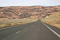
U.S. Route 160 in Arizona
-
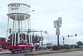
Former eastern end of US 160 in Poplar Bluff, Missouri.


See also
 In Spanish: U.S. Route 160 (Arizona) para niños
