Poplar Bluff, Missouri facts for kids
Quick facts for kids
Poplar Bluff, Missouri
|
|
|---|---|

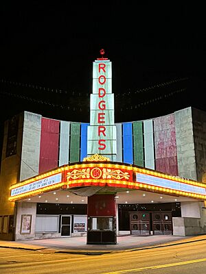
Rodgers Theatre Building (Art Deco architecture)
|
|
| Nickname(s):
Gateway to the Ozarks, The Bluff, PB
|
|
| Motto(s):
A Community of Opportunity
|
|
| Country | United States |
| State | Missouri |
| County | Butler |
| Government | |
| • Type | Council-Manager |
| Area | |
| • Total | 13.21 sq mi (34.22 km2) |
| • Land | 13.14 sq mi (34.03 km2) |
| • Water | 0.07 sq mi (0.19 km2) |
| Elevation | 348 ft (106 m) |
| Population
(2020)
|
|
| • Total | 16,225 |
| • Density | 1,234.87/sq mi (476.78/km2) |
| Time zone | UTC−6 (Central (CST)) |
| • Summer (DST) | UTC−5 (CDT) |
| ZIP Codes |
63901–63902
|
| Area code(s) | 573 |
| FIPS code | 29-59096 |
| GNIS feature ID | 2396252 |
Poplar Bluff is a city in Butler County in southeastern Missouri, United States. It is the main city of Butler County. People often call it "The Gateway to the Ozarks" because of its location. In 2020, about 16,225 people lived there. The city is an important meeting point for two major roads: U.S. Route 60 and U.S. Route 67.
Contents
History of Poplar Bluff
The French were the first Europeans to claim the land where Poplar Bluff is now. Later, the area was given to Spain in 1771 and then back to France in 1802. The first European families settled here around 1819. At that time, about 300 Native Americans lived in the area.
The first settlements in Butler County began in the early 1800s. They were along the Natchitoches Trail, an old Native American path. Butler County was officially formed in 1849, and Poplar Bluff was chosen as its main city. The first courthouse was built in 1855, and the town started to grow.
On May 9, 1927, a powerful tornado hit Poplar Bluff. It destroyed most of the city, especially the main business area. Sadly, 98 people lost their lives in this storm. It was one of the deadliest tornadoes in U.S. history.
Many buildings in Poplar Bluff are very old and important. They are listed on the National Register of Historic Places. This means they are protected because of their history and special design. Some examples include the Butler County Courthouse and the Rodgers Theatre Building.
Geography of Poplar Bluff
Poplar Bluff is located next to the Black River. The city covers about 12.98 square miles (33.62 km2) of land and a small amount of water.
The city gets its name from a high area, or "bluff," that overlooks the Black River. This bluff used to be covered with many tulip poplar trees. Today, the Butler County Courthouse and the local newspaper office stand on this spot. Poplar Bluff is where the hills of the Ozarks meet the flat lands of southeastern Missouri.
The area around Poplar Bluff is often called "Three Rivers." Many local groups and businesses use this name. The three rivers are the Current River, the Black River, and the St. Francis River. Poplar Bluff is right in the middle, on the Black River.
Climate in Poplar Bluff
Poplar Bluff has a humid subtropical climate. This means winters are cool with some snow, and summers are hot and sticky. It rains a lot throughout the year, especially in spring and fall.
January is the coldest month, with an average temperature of 34.9 °F (1.6 °C). July is the hottest, with an average of 80.5 °F (26.9 °C). On average, the temperature goes above 90 °F (32 °C) about 58 days a year. It rarely goes above 100 °F (38 °C). In winter, temperatures drop below freezing about 83 days a year.
The hottest temperature ever recorded was 112 °F (44 °C) in July 1901. The coldest temperature ever recorded was −25 °F (−32 °C) in February 1899.
| Climate data for Poplar Bluff, Missouri (1991–2020 normals, extremes 1893–present) | |||||||||||||
|---|---|---|---|---|---|---|---|---|---|---|---|---|---|
| Month | Jan | Feb | Mar | Apr | May | Jun | Jul | Aug | Sep | Oct | Nov | Dec | Year |
| Record high °F (°C) | 78 (26) |
83 (28) |
92 (33) |
94 (34) |
100 (38) |
110 (43) |
112 (44) |
112 (44) |
108 (42) |
96 (36) |
85 (29) |
79 (26) |
112 (44) |
| Mean maximum °F (°C) | 64.5 (18.1) |
70.1 (21.2) |
77.3 (25.2) |
84.5 (29.2) |
90.6 (32.6) |
96.5 (35.8) |
99.0 (37.2) |
98.6 (37.0) |
93.6 (34.2) |
86.5 (30.3) |
75.4 (24.1) |
65.3 (18.5) |
101.0 (38.3) |
| Mean daily maximum °F (°C) | 44.0 (6.7) |
49.3 (9.6) |
59.0 (15.0) |
69.9 (21.1) |
78.9 (26.1) |
87.5 (30.8) |
90.5 (32.5) |
89.5 (31.9) |
82.8 (28.2) |
71.9 (22.2) |
57.8 (14.3) |
47.1 (8.4) |
69.0 (20.6) |
| Daily mean °F (°C) | 34.9 (1.6) |
39.4 (4.1) |
48.5 (9.2) |
58.7 (14.8) |
68.3 (20.2) |
77.3 (25.2) |
80.5 (26.9) |
79.0 (26.1) |
71.7 (22.1) |
59.8 (15.4) |
47.7 (8.7) |
38.2 (3.4) |
58.7 (14.8) |
| Mean daily minimum °F (°C) | 25.8 (−3.4) |
29.5 (−1.4) |
38.1 (3.4) |
47.4 (8.6) |
57.6 (14.2) |
67.0 (19.4) |
70.6 (21.4) |
68.5 (20.3) |
60.6 (15.9) |
47.7 (8.7) |
37.5 (3.1) |
29.3 (−1.5) |
48.3 (9.1) |
| Mean minimum °F (°C) | 9.2 (−12.7) |
14.1 (−9.9) |
22.2 (−5.4) |
33.7 (0.9) |
43.6 (6.4) |
56.4 (13.6) |
62.6 (17.0) |
60.0 (15.6) |
46.6 (8.1) |
34.0 (1.1) |
23.7 (−4.6) |
14.7 (−9.6) |
5.7 (−14.6) |
| Record low °F (°C) | −23 (−31) |
−25 (−32) |
0 (−18) |
23 (−5) |
28 (−2) |
41 (5) |
48 (9) |
44 (7) |
31 (−1) |
17 (−8) |
4 (−16) |
−10 (−23) |
−25 (−32) |
| Average precipitation inches (mm) | 3.46 (88) |
3.63 (92) |
4.77 (121) |
5.94 (151) |
5.37 (136) |
4.29 (109) |
4.70 (119) |
3.65 (93) |
3.29 (84) |
4.07 (103) |
4.80 (122) |
4.27 (108) |
52.24 (1,327) |
| Average snowfall inches (cm) | 0.6 (1.5) |
1.6 (4.1) |
1.3 (3.3) |
0.0 (0.0) |
0.0 (0.0) |
0.0 (0.0) |
0.0 (0.0) |
0.0 (0.0) |
0.0 (0.0) |
0.0 (0.0) |
0.2 (0.51) |
1.7 (4.3) |
5.4 (14) |
| Average precipitation days (≥ 0.01 in) | 8.7 | 7.5 | 10.9 | 10.4 | 11.4 | 8.7 | 8.4 | 7.6 | 6.8 | 7.8 | 9.2 | 8.7 | 106.1 |
| Average snowy days (≥ 0.1 in) | 0.5 | 0.6 | 0.4 | 0.0 | 0.0 | 0.0 | 0.0 | 0.0 | 0.0 | 0.0 | 0.1 | 0.4 | 1.8 |
| Source: NOAA | |||||||||||||
People of Poplar Bluff (Demographics)
| Historical population | |||
|---|---|---|---|
| Census | Pop. | %± | |
| 1880 | 791 | — | |
| 1890 | 2,187 | 176.5% | |
| 1900 | 4,321 | 97.6% | |
| 1910 | 6,916 | 60.1% | |
| 1920 | 8,042 | 16.3% | |
| 1930 | 7,551 | −6.1% | |
| 1940 | 11,163 | 47.8% | |
| 1950 | 15,064 | 34.9% | |
| 1960 | 15,926 | 5.7% | |
| 1970 | 16,653 | 4.6% | |
| 1980 | 17,139 | 2.9% | |
| 1990 | 16,996 | −0.8% | |
| 2000 | 16,651 | −2.0% | |
| 2010 | 17,023 | 2.2% | |
| 2020 | 16,225 | −4.7% | |
| source: | |||
Poplar Bluff in 2020
The 2020 United States census counted 16,227 people living in Poplar Bluff. There were 6,566 households and 3,665 families. The city had about 1,235 people per square mile.
Most people in Poplar Bluff are white (77.37%). About 11.57% are Black or African-American. Other groups include Native American, Asian, and people of two or more races. About 2.5% of the population is Hispanic or Latino.
About a quarter of the households (24.2%) had children under 18. Many households (38.3%) were people living alone. The average age in the city was 36.2 years old. About 25.5% of the people were under 18.
Poplar Bluff in 2010
In 2010, there were 17,023 people living in Poplar Bluff. The city had 7,181 households. The population density was about 1,319 people per square mile.
The racial makeup of the city was mostly White (84.79%). About 9.97% were Black or African American. Other groups included Native American, Asian, and people of two or more races. About 2.21% of the population was Hispanic or Latino.
About 30.5% of households had children under 18. The average age in the city was 38.4 years. About 24.2% of residents were under 18 years old.
Economy of Poplar Bluff
Poplar Bluff is home to Mid-Continent Steel and Wire, a very large company that makes nails. It's one of the biggest nail makers in the United States. This company used to employ about 500 people in the area.
In 2019, the company received a special permission that helped them keep their workers and make more nails. This was good news for the city's economy.
Education in Poplar Bluff
Poplar Bluff has many schools for students of all ages.
Public Schools
The Poplar Bluff R-1 School District serves most students in the city. It has seven elementary schools, one junior high, and one high school. In the 2022–2023 school year, over 5,200 students attended these schools. The school colors are maroon and white, and their mascot is the mule.
The schools offer many sports and activities, like basketball, soccer, track, and band.
- Elementary Schools
- Poplar Bluff Early Childhood Center
- Poplar Bluff Kindergarten Center
- O'Neal Elementary
- Oak Grove Elementary
- Lake Road Elementary
- Eugene Field Elementary
- Poplar Bluff Middle School
- Secondary Schools
- Poplar Bluff Junior High School (grades 7 and 8)
- Poplar Bluff High School (grades 9 through 12)
- Poplar Bluff Technical Career Center
Private Schools
There are also private schools in Poplar Bluff:
- Sacred Heart Catholic School
- Thomas M. Lane Seventh-day Adventist Church School
- Westwood Baptist Academy
Colleges and Universities
Three Rivers College is located in Poplar Bluff. It offers college classes and programs to help students learn job skills. Students can take classes here that are similar to the first two years of a four-year university. The school's colors are gold and black, and its mascot is Rocky Raider.
Local News
The Daily American Republic Newspaper is the local newspaper for Poplar Bluff. You can read it in print or online at www.darnews.com.
Library
Poplar Bluff has a public library called the Poplar Bluff Public Library. It's a place where you can borrow books and other materials.
Transportation in Poplar Bluff
You can travel to Poplar Bluff by train with Amtrak service at the Poplar Bluff station.
The city also has a public transportation system called Bluff Area Transit Service. It runs four routes from Monday to Friday, helping people get around the city.
Poplar Bluff is located where two important U.S. routes meet: U.S. Route 60 and U.S. Route 67.
Notable People from Poplar Bluff
Many interesting people have come from Poplar Bluff:
- Linda Bloodworth-Thomason, a television producer who created shows like Designing Women
- Christian Boeving, a fitness model, bodybuilder, and actor
- Sean Fister, a World Long Drive Champion in golf
- Leroy Griffith, a theater owner and film producer
- Tyler Hansbrough, an NBA basketball player
- Scott Innes, a radio broadcaster and voice actor for Scooby-Doo
- Charles Jaco, a CNN reporter
- Billie G. Kanell, a Medal of Honor recipient from the U.S. Army
- Tim Lollar, a professional baseball pitcher
- Matt Lucas, a singer, drummer, and songwriter
- Kameron Misner, a professional baseball player
- Derland Moore, a professional football player
- William Wilson Morgan, an astronomer who studied the Milky Way galaxy
- Mikel Rouse, a composer
See also
 In Spanish: Poplar Bluff (Misuri) para niños
 | Claudette Colvin |
 | Myrlie Evers-Williams |
 | Alberta Odell Jones |


