Black River (Arkansas–Missouri) facts for kids
Quick facts for kids Black River |
|
|---|---|

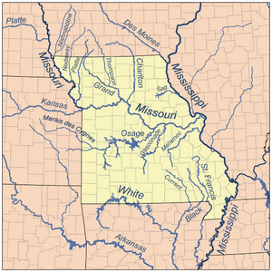
Map of major Missouri rivers
|
|
| Country | United States |
| States | Arkansas, Missouri |
| Physical characteristics | |
| Main source | Confluence of the East Fork and Middle Fork near Lesterville, Missouri 640 ft (200 m) 37°26′28″N 90°50′01″W / 37.4411111°N 90.8336111°W |
| River mouth | Confluence with the White River northwest of Newport, Arkansas 203 ft (62 m) 35°38′24″N 91°19′18″W / 35.64°N 91.3216667°W |
| Length | 300 mi (480 km) |
| Basin features | |
| Progression | Black River → White → Mississippi → Gulf of Mexico |
| GNIS ID | 66965 |
The Black River is a cool river in the United States. It flows through southeastern Missouri and northeastern Arkansas. This river is about 300 miles (480 km) long. It's like a smaller stream that flows into a bigger one, called a tributary. The Black River joins the White River. Then, the White River flows into the huge Mississippi River. So, the Black River is part of the Mississippi River's watershed. A watershed is all the land where water drains into a specific river. The river gets its name because its water sometimes looks a bit dark, or "black." There's even a college named after it: Black River Technical College!
Contents
Where the Black River Starts and Flows
The Black River actually begins in Missouri as three different streams. Think of them as three smaller rivers that come together to form one bigger river.
The Three Starting Streams
- The East Fork Black River starts in Iron County. It flows south through Johnson's Shut-Ins State Park. This park was once damaged by a problem at the Taum Sauk pumped storage plant. A dam on this fork creates the Taum Sauk Lower Reservoir. This reservoir holds water that is pumped up to a higher reservoir.
- The Middle Fork Black River forms when several smaller creeks meet. This happens in the Mark Twain National Forest in northern Reynolds County. It flows mostly southeast.
- The West Fork Black River also forms from creeks in the Mark Twain National Forest. It starts in western Reynolds County and flows east, passing by the town of Centerville.
The River's Journey
These three starting streams come together near Lesterville. From there, the Black River flows generally southward. It travels through several counties in Missouri, including Reynolds, Wayne, and Butler.
Then, it crosses into Arkansas. In Arkansas, it flows through Clay, Randolph, and Lawrence Counties. Near its end, the river helps mark the border between Independence and Jackson Counties.
The Black River flows past several towns along its way. In Missouri, it passes Mill Spring, Williamsville, and Poplar Bluff. In Arkansas, it goes by Pocahontas, Black Rock, and Powhatan. Finally, it joins the White River at Jacksonport, Arkansas.
Dams on the River
The United States Army Corps of Engineers built a dam on the Black River in Wayne County, Missouri. This dam created a large body of water called Clearwater Lake. Dams help control water flow and can create lakes for recreation.
Other Rivers Joining the Black River
Many smaller rivers and creeks flow into the Black River, adding to its size. These are called tributaries.
In Arkansas, the Black River is joined by:
- The Little Black River
- The Current River
- The Spring River
- The Strawberry River
In Missouri, a smaller stream called Mayberry Branch also flows into the Black River.
 | Selma Burke |
 | Pauline Powell Burns |
 | Frederick J. Brown |
 | Robert Blackburn |

