Mark Twain National Forest facts for kids

The Mark Twain National Forest (often called MTNF) is a special forest area in the United States. It's mostly found in the southern part of Missouri. This forest was created on September 11, 1939. It's named after the famous writer Mark Twain, who was born in Missouri.
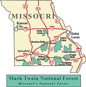
The Mark Twain National Forest covers a huge area of about 1.5 million acres (which is about 6,000 square kilometers). A small part of this, about 78,000 acres, is set aside as "wilderness" areas, where nature is left untouched. There are also parts of "Wild and Scenic Rivers" here. The forest spreads across 29 different counties in Missouri. It makes up about 11% of all the forested land in the state!
The MTNF is split into six main sections, called "ranger districts." These are: "Ava-Cassville-Willow Springs," "Eleven Point," "Houston-Rolla-Cedar Creek," "Poplar Bluff," "Potosi-Fredericktown," and "Salem." Even though there are six districts, the forest is actually made up of nine separate pieces of land. The main office for the Mark Twain National Forest is in Rolla, Missouri.
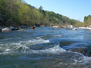
Some really cool spots in the Mark Twain National Forest include Greer Spring. This is the biggest natural spring on any National Forest land! It's part of the Eleven Point National Scenic River. This spring pumps out an amazing 214 million gallons of water every single day into the river. You can also visit the Glade Top Trail National Scenic Byway. From here, you can see over 30 miles (about 48 kilometers) away, all the way to the Boston Mountains in Arkansas. A part of the long Ozark Trail also goes through this beautiful forest.
Contents
Forest History: How It Began
The Mark Twain National Forest we know today was officially created on February 17, 1976. But before that, it was actually two separate national forests! These were called the "Clark National Forest" and the "Mark Twain National Forest." Both of them were first announced on September 11, 1939.
In June 1973, the Clark and Mark Twain forests started working together under one main office in Rolla. People called them the "National forests in Missouri." Then, on February 17, 1976, the two forests were officially joined together and renamed the Mark Twain National Forest.
Long ago, in the 1870s, people started cutting down many of the native oak, hickory, and pine trees in Missouri. There were many sawmills, which are places that cut logs into lumber. But by the 1920s, most of these sawmills were gone, and so were many of the state's original forests.
In 1939, President Franklin D. Roosevelt signed the papers that made the Mark Twain National Forest official. In March 1933, he also started a program called the Civilian Conservation Corps (CCC). Hundreds of young men from the CCC worked in the area that would become the Mark Twain National Forest. They built roads and planted millions of pine trees. Many of the things they built can still be seen and enjoyed in the forest today!
Amazing Features of the Mark Twain Forest
The Mark Twain is the only national forest in Missouri. It covers about 1.5 million acres, mostly within an area called the Ozark Highlands. The Ozark Highlands stretch across southern Missouri and northern Arkansas. This is a very old landscape with many large, natural springs.
The area also has over 5,000 caves! It's made up of ancient volcanic mountains and has many famous streams. Some parts of the Ozarks were never covered by oceans or huge sheets of ice (glaciers).
There are over 750 miles (about 1,200 kilometers) of hiking trails in the forest. About 200 miles of a planned 500-mile Ozark Trail have been finished. When it's all done, this trail will connect St. Louis to the border of Arkansas. There, it will link up with the Ozark Highlands Trail in northwest Arkansas. Once both trails are complete, you'll be able to hike over 1,000 miles (about 1,600 kilometers) from St. Louis, Missouri, all the way to Lake Fort Smith State Park, near Fort Smith, Arkansas.
Wilderness Areas to Explore
Within the Mark Twain National Forest, there are special places called "wilderness areas." These are parts of the forest where nature is protected and left wild, with very few signs of human activity. They are great places to experience true wilderness.
- Bell Mountain Wilderness
- Devils Backbone Wilderness
- Hercules-Glades Wilderness
- Irish Wilderness
- Paddy Creek Wilderness
- Piney Creek Wilderness
- Rockpile Mountain Wilderness
Many Counties, One Forest
Even though the Mark Twain National Forest isn't the biggest national forest in terms of total land size, it is located in more counties than any other national forest! As of September 30, 2007, its nearly 1.5 million acres were spread across parts of 29 different counties in southern and central Missouri.
 | DeHart Hubbard |
 | Wilma Rudolph |
 | Jesse Owens |
 | Jackie Joyner-Kersee |
 | Major Taylor |


