
Greer Spring facts for kids
Quick facts for kids Greer Spring |
|
|---|---|
 |
|
| Native name | Big Ozark Spring |
| Country | United States |
| State | Missouri |
| Region | Ozark Plateau |
| Physical characteristics | |
| Main source | Greer Spring Outlet Eleven Point River basin, Salem Plateau, Ozark Plateau, Missouri 564 ft (172 m) 36°47′12″N 91°20′51″W / 36.78667°N 91.34750°W |
| River mouth | Eleven Point River Greer, Oregon County, Ozark Plateau, Missouri 519 ft (158 m)USGS 7.5 min topo quad map |
| Length | 1.4 mi (2.3 km) |
| Basin features | |
| U.S. NNL | Designated: 1980 |
Greer Spring is a very large spring located in the southeastern part of the Ozark Plateau in Oregon County, Missouri. It is found within the Mark Twain National Forest. This spring is the second largest in the Ozarks. It releases about 360 cubic feet (10 m3) of water every second. Greer Spring was named a National Natural Landmark in 1980. This means it is a special natural place in the United States.
The Spring's Water Flow
The water from Greer Spring comes out from deep inside a narrow canyon. A smaller stream flows from a cave, but most of the water comes from the main outlet. About 100 feet (30 m) downstream, the main spring bursts to the surface. It creates a mix of deep, clear blue water, green mossy rocks, and foamy whitewater.
This new stream then rushes down a small, steep valley. This valley is covered with hardwood trees. The stream drops 65 feet (20 m) in height over 1.2 miles (1.9 km). It then joins the Eleven Point River. Greer Spring adds a huge amount of water to the river. This helps make sure there is enough water for fun activities like boating, even when it's dry.
The spring's very cold water also changes the Eleven Point River. It becomes a coldwater stream for several miles. This creates perfect conditions for trout fish to live. The place where the spring stream meets the river is about 0.5 miles upstream from the Missouri Route 19 bridge. Greer Spring might be the most untouched large spring in the Ozarks. The U.S. National Forest Service has owned the spring since 1993. Before that, private owners took care of it. The area around the spring is now wild again. Long ago, there was a small fish hatchery and roads here. Still, the site remains very beautiful and natural.

How to Visit Greer Spring
The U.S. National Forest Service keeps a trail open for visitors to reach the spring. The start of the trail is about 18 miles (29 km) south of Winona. It is also 8 miles (13 km) north of Alton. You can find it on Missouri Highway 19. It's about 1.5 miles (2.4 km) south of the Highway 19 bridge over the Eleven Point River. It is just north of the small town of Greer.
There is a parking area next to Highway 19 for visitors. Many people visit the spring, even though it requires a mile-long hike.
A Look at History

The very first gristmill on the spring branch was built in 1859. It was built by Captain Samuel Greer. The spring was later named after this Confederate captain. This first mill was destroyed during the American Civil War. However, it was rebuilt later.
After 1883, the old mill was taken down. A new roller mill was built in its place before 1899. The mill was owned by different people until 1922. That's when it stopped working. Today, very few parts of the old mill operations are left near the spring. The mill building itself is still standing. It is near the top of the east side of the valley.
As of 2016, work is being done to restore the mill. The U.S. Forest Service and HistoriCorps are helping with this project. It has been hard to reach the spring and mill. Also, it was privately owned for a long time. These things have helped protect this special karst area.
Images for kids
-
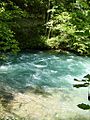
Greer Spring main outlet. Pictured here discharging 401 cu ft/s (11.4 m3/s).
