Randolph County, Arkansas facts for kids
Quick facts for kids
Randolph County
|
|
|---|---|
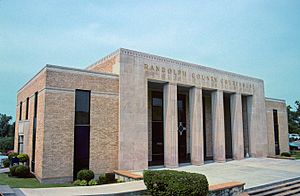
Randolph County courthouse in Pocahontas
|
|
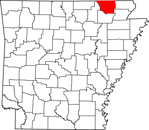
Location within the U.S. state of Arkansas
|
|
 Arkansas's location within the U.S. |
|
| Country | |
| State | |
| Founded | October 29, 1835 |
| Named for | John Randolph |
| Seat | Pocahontas |
| Largest city | Pocahontas |
| Area | |
| • Total | 656.04 sq mi (1,699.1 km2) |
| • Land | 651.83 sq mi (1,688.2 km2) |
| • Water | 4.21 sq mi (10.9 km2) 0.6%% |
| Population
(2020)
|
|
| • Total | 18,571 |
| • Estimate
(2023)
|
18,907 |
| • Density | 28.3077/sq mi (10.9297/km2) |
| Time zone | UTC−6 (Central) |
| • Summer (DST) | UTC−5 (CDT) |
| Congressional district | 1st |
Randolph County is a place in Arkansas, a state in the United States. It sits between the Ozark Mountains and the Arkansas Delta. The county is named after John Randolph of Roanoke, a senator from Virginia. He helped make the Louisiana Purchase happen, which included this area.
Randolph County was created on October 29, 1835. It was the 32nd county in Arkansas. Today, it has two main cities, including Pocahontas, which is the county seat and its biggest city. You can also find many small towns and even some ghost towns here.
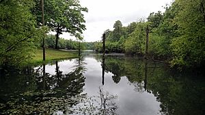
Five rivers flow through Randolph County. Most of the county has rolling hills and valleys, like the Ozarks. But the eastern part is flat with rich soil, like the Delta. The Black River generally divides these two areas. The county also has three special protected areas. These include two places for wildlife and Davidsonville Historic State Park, which teaches about early settlers. You can also see old log cabins, one-room schoolhouses, and museums that share the county's history.
Randolph County covers about 656 square miles (1,700 square kilometers). In 2020, about 18,571 people lived here. The main jobs are in farming and small factories.
Two school districts serve Randolph County: Pocahontas School District and Maynard School District. For college, there's Black River Technical College in Pocahontas. The St. Bernards Five Rivers Medical Center in Pocahontas provides healthcare. While there are no big Interstate highways, the county has access to three major US highways and many state highways. There is also a local airport, Pocahontas Municipal Airport.
Contents
Exploring Randolph County's Geography
Randolph County is where the Ozark Mountains meet the Arkansas Delta. The Ozarks are a hilly region, and the Delta is a flat area with fertile soil. This soil comes from the Mississippi River. The Black River acts like a natural border between these two areas in Randolph County.
The county covers about 656 square miles. Most of this is land (651.83 square miles), and a small part is water (4.21 square miles).
Randolph County is about 144 miles (232 km) northeast of Little Rock. It's also about 108 miles (174 km) northwest of Memphis, Tennessee. The county shares borders with other counties in Arkansas and two counties in Missouri.
Rivers and Waterways
Water is very important to Randolph County's history and way of life. Many rivers and streams cross the county. Long ago, Native American tribes like the Lenape and Cherokee lived along these waterways.
Randolph County has five main rivers: the Black River, Current River, Eleven Point River, Fourche River, and Spring River.
The Black River flows from east to west. It meets the Current River and Fourche River near Pocahontas. The Current River forms part of the county's border before turning southwest. The Fourche River also flows south into the Black River. The Black River then meets the Spring River at the southern tip of the county.
The Spring River forms part of the county's border with Lawrence County. The Eleven Point River enters from Missouri and flows into the Spring River.
In the past, these rivers were important for travel and trade. During the Civil War, controlling the rivers was key for military actions. After the war, natural mineral springs in places like Warm Springs attracted visitors who believed the water had healing powers.
Protected Natural Areas
Randolph County is home to one state park and two Wildlife Management Areas (WMAs). These areas are managed by the Arkansas Game and Fish Commission and the Arkansas Department of Parks and Tourism.
The Dave Donaldson/Black River WMA protects bottomland hardwood forests. It's also a winter home for many migratory birds. This WMA was created in 1957 and covers over 25,000 acres (10,000 ha). The Robert L. Hankins/Mud Creek Upland WMA was started in 1989. It has 1,250 acres (510 ha) of upland hardwood forest. People can go birding, hunting, and hiking in this area.
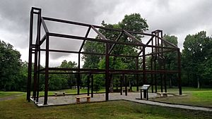
Davidsonville Historic State Park is a 163-acre (66 ha) park. It focuses on the history of an old frontier town called Davidsonville. This town was once a very important stop on the Black River. But by 1836, it was abandoned as river travel changed. The park helps us learn about this early settlement.
Population and People
| Historical population | |||
|---|---|---|---|
| Census | Pop. | %± | |
| 1840 | 2,196 | — | |
| 1850 | 3,275 | 49.1% | |
| 1860 | 6,261 | 91.2% | |
| 1870 | 7,466 | 19.2% | |
| 1880 | 11,724 | 57.0% | |
| 1890 | 14,485 | 23.5% | |
| 1900 | 17,156 | 18.4% | |
| 1910 | 18,987 | 10.7% | |
| 1920 | 17,713 | −6.7% | |
| 1930 | 16,871 | −4.8% | |
| 1940 | 18,319 | 8.6% | |
| 1950 | 15,982 | −12.8% | |
| 1960 | 12,520 | −21.7% | |
| 1970 | 12,645 | 1.0% | |
| 1980 | 16,834 | 33.1% | |
| 1990 | 16,558 | −1.6% | |
| 2000 | 18,195 | 9.9% | |
| 2010 | 17,969 | −1.2% | |
| 2020 | 18,571 | 3.4% | |
| 2023 (est.) | 18,907 | 5.2% | |
| U.S. Decennial Census 1790–1960 1900–1990 1990–2000 2010–2016 |
|||
In 2020, about 18,571 people lived in Randolph County. There were 7,355 households and 4,994 families.
The population density was about 27 people per square mile (10 people per square kilometer). In 2010, about 23.2% of the people were under 18 years old. The average age was 41.9 years.
Economy and Jobs
| Rank | Employer | Employees |
|---|---|---|
| 1 | Peco Foods | 500 |
| 2 | Pocahontas School District | 255 |
| 3 | Walmart Stores Inc | 212 |
| 4 | Black River Technical College | 200 |
| 5 | St. Bernards Five Rivers Medical Center | 180 |
| 6 | Randolph County Nursing Home | 170 |
| 7 | Pocahontas Aluminum | 129 |
| 8 | Pocahontas Healthcare & Rehab | 100 |
| 9 | Above & Beyond Home Care | 79 |
| 10 | Maclean-Fogg | 46 |
Many people in Randolph County work in different areas. The biggest job sectors are professional services, government, trade, agriculture, and manufacturing.
The county is mostly rural with some small factories. The median income for a household in 2000 was $27,583.
Education and Learning
Most adults in Randolph County have a high school degree. About 82.5% of people over 25 have finished high school. About 13.4% have a bachelor's degree or higher.
Schools for Kids and Teens
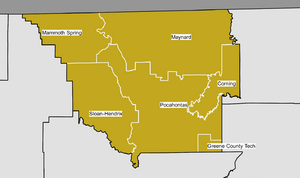
Two public school districts are in Randolph County. The Pocahontas School District is the largest. The Maynard School District serves the northeast part of the county. Students graduate from Pocahontas High School or Maynard High School. Both schools offer advanced classes and are approved by the Arkansas Department of Education.
Some residents live in areas served by other school districts. These include the Mammoth Spring School District and the Sloan-Hendrix School District.
Colleges and Higher Education
Randolph County has one college, Black River Technical College. It's a public two-year college in Pocahontas. Other colleges nearby include Arkansas State University in Jonesboro. There are also two private colleges, Crowley's Ridge College and Williams Baptist College.
Public Library
The Randolph County Library (RCL) is in downtown Pocahontas. It's part of the Northeast Arkansas Regional Library System. The library offers books, e-books, movies, and help with research. It also has special services for kids and for learning about family history.
Culture and Daily Life
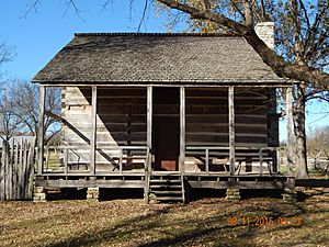
Randolph County has many places that help preserve its history and culture. You can find several old log cabins from the pioneer days. The Rice-Upshaw House, built around the 1820s, is one of Arkansas's oldest buildings. The county also has the Hillyard Cabin and the Looney-French House. These are listed on the National Register of Historic Places.
There are also historic schools and community centers. The Cedar Grove School No. 81 is an old one room schoolhouse now used by the community. The Eddie Mae Herron Center & Museum was once a school for Black students. Today, it's a community center and museum. Other historic schools include Old Union School and Ravenden Springs School.
Other interesting places include:
- Century Wall Monument: This monument celebrates important Americans from the 1900s.
- Davidsonville Historic State Park: A park that teaches about an early abandoned town.
- Maynard Pioneer Museum: This museum celebrates the first settlers of the area.
- Old Randolph County Courthouse: This restored 1875 building is now used by the Chamber of Commerce.
In 2018, voters in Randolph County decided to allow sales of alcoholic drinks. Before this, the county had been "dry" (meaning alcohol sales were not allowed) for about 70 years.
Communities in Randolph County
Randolph County has two cities and four towns. The largest city and county seat is Pocahontas. It's in the south-central part of the county by the Black River. In 2010, Pocahontas had 6,608 people.
The county's small towns each have fewer than 500 people. Ravenden Springs is the smallest, with 118 people in 2010. Other towns include Maynard, Biggers, Reyno, and O'Kean.
Randolph County also has many small, unnamed communities and ghost towns. Early settlers often lived in small groups rather than in official towns. Some of these places, like Davidsonville, once had post offices and many buildings. Others are just a few homes at a crossroads.
Cities
- Pocahontas (County Seat)
- Reyno
Towns
Unincorporated Communities
- Antioch
- Attica
- Birdell
- Brakebill
- Brockett
- Cedar Grove
- Dalton
- Dunn
- East Pocahontas
- Elevenpoint
- Elkins Park
- Elm Store
- Elnora
- Engelberg
- Fender
- Glaze Creek
- Gravesville
- Hamil
- Hoover Landing
- Ingram
- Jerrett
- Lesterville
- Lorine
- Manson
- Middlebrook
- Minorca
- Noland
- Old Reyno
- Old Siloam
- Palestine
- Pitman
- Shannon
- Sharum
- Skaggs
- Stokes
- Stoney Point
- Supply
- Warm Springs
- Washington
Historical Communities
- Baker Den
- Davidsonville
- Debrow
- Keller
- Kingsville
- Mock
- Oconee
- Poluca
- Running Lake
- Watervalley
- Yadkin
Townships
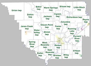
Townships in Arkansas are the divisions of a county. Each township includes unincorporated areas; some may have incorporated cities or towns within part of their boundaries. Arkansas townships have limited purposes in modern times. However, the United States Census does list Arkansas population based on townships (sometimes referred to as "county subdivisions" or "minor civil divisions"). Townships are also of value for historical purposes in terms of genealogical research. Each town or city is within one or more townships in an Arkansas county based on census maps and publications. The townships of Randolph County are listed below; listed in parentheses are the cities, towns, and/or census-designated places that are fully or partially inside the township.
- Baker
- Bristow
- Butler
- Columbia
- Current River (Biggers)
- Dalton
- Demun (Pocahontas)
- East Roanoke
- Eleven Point
- Foster
- Ingram
- Jackson
- Janes Creek (Ravenden Springs)
- Little Black
- O'Kean (O'Kean)
- Reyno (Reyno)
- Richardson (Maynard)
- Running Lake
- Shiloh
- Siloam
- Spring River
- Union
- Warm Springs
- Water Valley
- West Roanoke
- Wiley
Transportation and Utilities
Air Travel
Randolph County has one public airport, Pocahontas Municipal Airport. It's also known as Nick Wilson Field. This airport is mainly for small planes. The closest big airport for commercial flights is Memphis International Airport.
Major Roads
No Interstate highways run through Randolph County. The closest one is Interstate 555 in Jonesboro. However, several important US highways cross the county. U.S. Route 62 (US 62) goes from east to west. It connects Randolph County to other cities in northern Arkansas. US 62 meets US 67 in Pocahontas. US 67 goes south towards Little Rock, the state capital.
Eleven Arkansas state highways also serve the county. Some, like Highway 34 and Highway 90, run east-west. Others, like Highway 93 and Highway 115, go north to the Missouri state line. Highway 361 connects to Davidsonville Historic State Park.
Water Systems
The Arkansas Department of Health oversees public water systems. Randolph County has six community water systems. These include Biggers Water Department and Pocahontas Water and Sewer. Most of these systems get their water from underground wells. Pocahontas and the Northeast Arkansas Public Water Authority use surface water from the Black River and Spring River.
Notable People from Randolph County
- Joseph J. Alexander: He was Randolph County's first representative in Arkansas's first State Assembly.
- George Nicholas 'Nick' Wilson: He was an Arkansas lawyer and political leader. He served in the Arkansas Senate for nearly 30 years.
See also
 In Spanish: Condado de Randolph (Arkansas) para niños
 | Anna J. Cooper |
 | Mary McLeod Bethune |
 | Lillie Mae Bradford |


