Pocahontas, Arkansas facts for kids
Quick facts for kids
Pocahontas, Arkansas
|
||
|---|---|---|

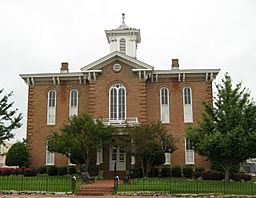
Old Randolph County Courthouse in downtown Pocahontas
|
||
|
||

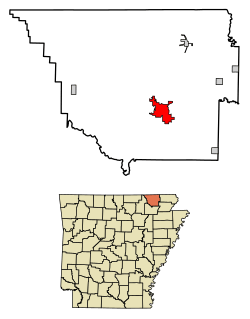
Location of Pocahontas in Randolph County, Arkansas.
|
||
| Country | United States | |
| State | Arkansas | |
| County | Randolph | |
| Area | ||
| • Total | 7.85 sq mi (20.34 km2) | |
| • Land | 7.64 sq mi (19.78 km2) | |
| • Water | 0.22 sq mi (0.56 km2) | |
| Elevation | 331 ft (101 m) | |
| Population
(2020)
|
||
| • Total | 7,371 | |
| • Density | 965.30/sq mi (372.72/km2) | |
| Time zone | UTC-6 (Central (CST)) | |
| • Summer (DST) | UTC-5 (CDT) | |
| ZIP code |
72455
|
|
| Area code(s) | 870 | |
| FIPS code | 05-56540 | |
| GNIS feature ID | 2404544 | |
Pocahontas is a city in Arkansas, United States. It is the county seat of Randolph County. The city is located along the Black River. In 2020, about 7,371 people lived there.
Pocahontas has several old and important buildings. These include the Old Randolph County Courthouse, built in 1871. There is also the St. Mary's AME Church. The Pocahontas Colored School, built in 1918, is now the Eddie Mae Herron Center.
Contents
History of Pocahontas
How Pocahontas Got Its Name
The city of Pocahontas was named after the famous Native American woman. She was from Jamestown, Virginia. You can find a statue of her in Overlook Park, right by the Black River.
Early Settlers and County Beginnings
The Bettis family is known as the first group of settlers in the area now called Pocahontas. Dr. Ransom S. Bettis's daughter, Cinderella, married Thomas S. Drew. They lived on a large piece of land where the town of Biggers is today. Dr. Bettis and Thomas Drew helped start Pocahontas as the main city, or county seat, for Randolph County.
Randolph County's Firsts
Randolph County is famous for many "firsts" in Arkansas.
- Davidsonville was established in 1815, making it Arkansas's oldest town.
- The first post office in Arkansas was built in Davidsonville in 1817.
- The first state courthouse was set up there in 1818.
- The earliest land claim in the area was in 1809, near what is now Ravenden Springs.
- The first court meeting in Arkansas happened in 1815. This was in a part of Lawrence County that later became Randolph County.
- The country's first overland route, the Natchitoches Trail, also went through parts of Randolph County.
Forming Randolph County
In 1835, the government decided to create Randolph County. It was formed from a part of the area then known as Lawrence County. The county was named after John Randolph, one of the first people to settle there.
Geography and Economy of Randolph County
Randolph County has different types of land. To the west, you'll find the rolling hills of the Ozarks. To the east, there are flat, rich farmlands of the Mississippi Delta. Five rivers flow through the county. These rivers are great for fishing and canoeing.
Farmers in the Delta region mainly grow soybeans, rice, and other grains. In the hill country, cattle ranching is more common. The poultry industry, which raises chickens and other birds, is also a very important part of the local economy.
Pocahontas During the Civil War
During the early part of the Civil War, a place called Camp Shaver was in Pocahontas. This camp was the main base for Confederate soldiers west of the Mississippi River.
Local Industries and Towns
Pocahontas has many different types of businesses. They make things like shoes, large truck trailers, and parts for communication devices. Other products include picture frames, golf bags, luggage, and tool boxes. They also make various wood products.
Pocahontas is the county seat and has a population of about 6,616 people. The other 10,407 residents of Randolph County live in rural areas. They also live in five smaller towns: Maynard, Biggers, Reyno, Ravenden Springs, and O'Kean.
A Local Legend About the County Seat
There's a local story about how Pocahontas became the county seat. The legend says that during a county meeting to decide which city would get the title, the people from Pocahontas brought a lot of alcohol. They shared it with the other groups. When it was time to vote, the only group not affected was the one from Pocahontas. So, they won the vote!
Geography and Climate
Pocahontas's Location and Size
According to the United States Census Bureau, the city covers a total area of about 7.6 square miles (19.7 square kilometers). Most of this area, about 7.3 square miles (18.9 square kilometers), is land. The rest, about 0.2 square miles (0.5 square kilometers), is water.
Understanding the Climate
Pocahontas has a climate with warm temperatures and rain spread out throughout the year. This type of weather is called a "Cfa" climate. It means the area has hot, humid summers and mild winters.
| Climate data for Pocahontas, Arkansas (1991–2020 normals, extremes 1871–present) | |||||||||||||
|---|---|---|---|---|---|---|---|---|---|---|---|---|---|
| Month | Jan | Feb | Mar | Apr | May | Jun | Jul | Aug | Sep | Oct | Nov | Dec | Year |
| Record high °F (°C) | 78 (26) |
85 (29) |
93 (34) |
98 (37) |
103 (39) |
109 (43) |
111 (44) |
112 (44) |
107 (42) |
96 (36) |
88 (31) |
82 (28) |
112 (44) |
| Mean daily maximum °F (°C) | 45.6 (7.6) |
50.4 (10.2) |
60.1 (15.6) |
70.8 (21.6) |
78.6 (25.9) |
87.0 (30.6) |
89.8 (32.1) |
88.8 (31.6) |
82.7 (28.2) |
72.4 (22.4) |
58.8 (14.9) |
48.5 (9.2) |
69.5 (20.8) |
| Daily mean °F (°C) | 35.7 (2.1) |
39.8 (4.3) |
48.8 (9.3) |
58.7 (14.8) |
67.5 (19.7) |
76.1 (24.5) |
79.6 (26.4) |
78.2 (25.7) |
71.2 (21.8) |
59.8 (15.4) |
47.7 (8.7) |
38.9 (3.8) |
58.5 (14.7) |
| Mean daily minimum °F (°C) | 25.8 (−3.4) |
29.1 (−1.6) |
37.5 (3.1) |
46.5 (8.1) |
56.4 (13.6) |
65.2 (18.4) |
69.3 (20.7) |
67.6 (19.8) |
59.6 (15.3) |
47.2 (8.4) |
36.5 (2.5) |
29.3 (−1.5) |
47.5 (8.6) |
| Record low °F (°C) | −20 (−29) |
−22 (−30) |
6 (−14) |
20 (−7) |
31 (−1) |
43 (6) |
48 (9) |
47 (8) |
35 (2) |
20 (−7) |
7 (−14) |
−11 (−24) |
−22 (−30) |
| Average precipitation inches (mm) | 3.81 (97) |
3.94 (100) |
4.74 (120) |
5.37 (136) |
5.38 (137) |
3.46 (88) |
3.65 (93) |
3.90 (99) |
3.84 (98) |
3.86 (98) |
4.85 (123) |
4.65 (118) |
51.45 (1,307) |
| Average snowfall inches (cm) | 2.3 (5.8) |
1.9 (4.8) |
1.4 (3.6) |
0.0 (0.0) |
0.0 (0.0) |
0.0 (0.0) |
0.0 (0.0) |
0.0 (0.0) |
0.0 (0.0) |
0.1 (0.25) |
0.2 (0.51) |
0.4 (1.0) |
6.3 (16) |
| Average precipitation days (≥ 0.01 in) | 8.5 | 8.1 | 9.0 | 9.4 | 10.2 | 7.4 | 8.3 | 7.0 | 6.2 | 7.7 | 8.3 | 8.7 | 98.8 |
| Average snowy days (≥ 0.1 in) | 1.0 | 1.0 | 0.3 | 0.0 | 0.0 | 0.0 | 0.0 | 0.0 | 0.0 | 0.0 | 0.1 | 0.6 | 3.0 |
| Source: NOAA | |||||||||||||
Population and People
How Many People Live Here?
| Historical population | |||
|---|---|---|---|
| Census | Pop. | %± | |
| 1880 | 325 | — | |
| 1890 | 507 | 56.0% | |
| 1900 | 967 | 90.7% | |
| 1910 | 1,547 | 60.0% | |
| 1920 | 1,806 | 16.7% | |
| 1930 | 1,896 | 5.0% | |
| 1940 | 3,028 | 59.7% | |
| 1950 | 3,840 | 26.8% | |
| 1960 | 3,665 | −4.6% | |
| 1970 | 4,544 | 24.0% | |
| 1980 | 5,995 | 31.9% | |
| 1990 | 6,151 | 2.6% | |
| 2000 | 6,518 | 6.0% | |
| 2010 | 6,608 | 1.4% | |
| 2020 | 7,371 | 11.5% | |
| U.S. Decennial Census | |||
The population of Pocahontas has grown a lot over the years. In 1880, only 325 people lived here. By 2020, the population had grown to 7,371 people.
Pocahontas Population in 2020
| Group | Number | Percentage |
|---|---|---|
| White (not Hispanic) | 6,028 | 81.78% |
| Black or African American (not Hispanic) | 106 | 1.44% |
| Native American | 38 | 0.52% |
| Asian | 50 | 0.68% |
| Pacific Islander | 570 | 7.73% |
| Other/Mixed backgrounds | 326 | 4.42% |
| Hispanic or Latino | 253 | 3.43% |
As of the 2020 United States census, there were 7,371 people living in Pocahontas. These people lived in 2,748 households. There were also 1,575 families in the city.
Education in Pocahontas
Pocahontas is home to the Pocahontas School District. This district includes several public schools:
- Alma Spikes Elementary School
- M. D. Williams Intermediate School
- Pocahontas Junior High School
- Pocahontas High School
The mascot for Pocahontas schools is the Redskins. Pocahontas also has a private Catholic school called St. Paul Elementary School. It serves students from pre-kindergarten to sixth grade. St. Paul's mascot is the Sabers.
In addition to K-12 schools, Pocahontas is also home to Black River Technical College. This college offers higher education and training.
Media and News
Local Newspapers
The Pocahontas Star Herald is the local newspaper. It comes out every Thursday. This newspaper started in 1880 and is owned by Corning Publishing.
Radio Stations
Pocahontas has several radio stations: KPOC, KRLW, and KIYS.
- KPOC-FM is known as Lite 104.1 FM.
- KPOC is News Sports Talk 1420 AM.
- KIYS is Country 106.3 FM.
- KRLW is Oldies 1320 AM.
Even though KRLW and KIYS broadcast to the Walnut Ridge/Hoxie area, their main offices are in Pocahontas. All these stations are run by Combined Media Group Inc.
City Infrastructure
Major Highways
Several important highways pass through Pocahontas, making it easy to travel to and from the city:
Medical Care
The city has medical facilities to help its residents:
- St. Bernards Five Rivers Medical Center
- Pocahontas Medical Clinic
Airport
Pocahontas also has its own airport, the Pocahontas Municipal Airport (M70).
Notable People from Pocahontas
Many interesting people have connections to Pocahontas:
- William Herbert Allaire Jr. - A U.S. Army general.
- Larry P. Arnn - Born in Pocahontas, he is the president of Hillsdale College in Michigan.
- Edwin Bethune - A former member of the United States House of Representatives, he graduated from Pocahontas High School.
- Drew Bowers - An Arkansas politician and lawyer, born near Pocahontas in 1886.
- Linda Collins-Smith - A Republican member of the Arkansas Senate and a business owner.
- Jim Johnston - A former composer for World Wrestling Entertainment.
- Billy Lee Riley - A rockabilly musician and singer from Pocahontas.
- Wear Schoonover - Also from Pocahontas, he was the first University of Arkansas athlete to be named to an All-American team in any sport.
- Trey Steimel - A member of the Alabama House of Representatives.
See also
 In Spanish: Pocahontas (Arkansas) para niños
 | Toni Morrison |
 | Barack Obama |
 | Martin Luther King Jr. |
 | Ralph Bunche |


