
Lawrence County, Arkansas facts for kids
Quick facts for kids
Lawrence County
|
|
|---|---|

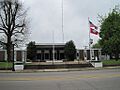
Lawrence County Courthouse
|
|

Location within the U.S. state of Arkansas
|
|
 Arkansas's location within the U.S. |
|
| Country | |
| State | |
| Founded | January 15, 1815 |
| Named for | James Lawrence |
| Seat | Walnut Ridge |
| Largest city | Walnut Ridge |
| Area | |
| • Total | 592 sq mi (1,530 km2) |
| • Land | 588 sq mi (1,520 km2) |
| • Water | 4.7 sq mi (12 km2) 0.8%% |
| Population
(2020)
|
|
| • Total | 16,216 |
| • Density | 27.392/sq mi (10.576/km2) |
| Time zone | UTC−6 (Central) |
| • Summer (DST) | UTC−5 (CDT) |
| Congressional district | 1st |
Lawrence County is a county found in the state of Arkansas. In 2020, about 16,216 people lived there. The main town and center of the county government is Walnut Ridge.
Lawrence County was created on January 15, 1815. It was the second county ever formed in Arkansas. The county is named after Captain James Lawrence, a brave naval officer who fought in the War of 1812.
Contents
History of Lawrence County
After the Louisiana Purchase, the land that is now Lawrence County was part of the Louisiana Territory from 1805 to 1812. Then, it became part of the Missouri Territory until 1819. That's when the Arkansas Territory was created.
Lawrence County was officially formed on January 15, 1815. It was made from parts of New Madrid County and Arkansas County. At first, it was a very large area. It stretched from Cape Girardeau County all the way to the Arkansas River.
Geography of Lawrence County
Lawrence County covers a total area of about 592 square miles. Most of this area, about 588 square miles, is land. The remaining 4.7 square miles, or 0.8%, is water.
Neighboring Counties
Lawrence County shares its borders with several other counties. Knowing these helps you understand its location better.
- Randolph County is to the north.
- Greene County is to the east.
- Craighead County is to the southeast.
- Jackson County is to the south.
- Independence County is to the southwest.
- Sharp County is to the west.
Population and People
The number of people living in Lawrence County has changed over many years. Here's a look at how the population has grown and shrunk.
| Historical population | |||
|---|---|---|---|
| Census | Pop. | %± | |
| 1830 | 2,806 | — | |
| 1840 | 2,835 | 1.0% | |
| 1850 | 5,274 | 86.0% | |
| 1860 | 9,372 | 77.7% | |
| 1870 | 5,981 | −36.2% | |
| 1880 | 8,782 | 46.8% | |
| 1890 | 12,984 | 47.8% | |
| 1900 | 16,491 | 27.0% | |
| 1910 | 20,001 | 21.3% | |
| 1920 | 22,098 | 10.5% | |
| 1930 | 21,663 | −2.0% | |
| 1940 | 22,651 | 4.6% | |
| 1950 | 21,303 | −6.0% | |
| 1960 | 17,267 | −18.9% | |
| 1970 | 16,320 | −5.5% | |
| 1980 | 18,447 | 13.0% | |
| 1990 | 17,457 | −5.4% | |
| 2000 | 17,774 | 1.8% | |
| 2010 | 17,415 | −2.0% | |
| 2020 | 16,216 | −6.9% | |
| 2023 (est.) | 16,318 | −6.3% | |
| U.S. Decennial Census 1790–1960 1900–1990 1990–2000 2010 |
|||

Who Lives in Lawrence County?
The 2020 United States census counted 16,216 people living in Lawrence County. There were 6,463 households and 4,466 families.
Here's a breakdown of the different groups of people in the county:
| Group | Number | Percentage |
|---|---|---|
| White (not Hispanic) | 14,925 | 92.04% |
| Black or African American (not Hispanic) | 138 | 0.85% |
| Native American | 41 | 0.25% |
| Asian | 38 | 0.23% |
| Pacific Islander | 10 | 0.06% |
| Other/Mixed | 707 | 4.36% |
| Hispanic or Latino | 357 | 2.2% |
Education in Lawrence County
Students in Lawrence County can attend public schools in four different school districts:
- Hillcrest School District
- Hoxie School District
- Lawrence County School District
- Sloan–Hendrix School District
Communities in Lawrence County
Lawrence County has several towns and cities where people live.
Cities
- Black Rock
- Hoxie
- Walnut Ridge (This is the county seat, where the main government offices are.)
Towns
Important Roads and Highways
Many important roads run through Lawrence County. These highways help people travel and transport goods across the area.
Images for kids
-
Lawrence County Courthouse
-
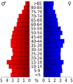
Age pyramid Lawrence County
See also
 In Spanish: Condado de Lawrence (Arkansas) para niños
