
Hoxie, Arkansas facts for kids
Quick facts for kids
Hoxie, Arkansas
|
|
|---|---|
 |
|

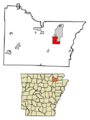
Location of Hoxie in Lawrence County, Arkansas.
|
|
| Country | United States |
| State | Arkansas |
| County | Lawrence |
| Government | |
| • Type | Municipal |
| Area | |
| • Total | 6.67 sq mi (17.26 km2) |
| • Land | 6.67 sq mi (17.26 km2) |
| • Water | 0.00 sq mi (0.00 km2) |
| Elevation | 266 ft (81 m) |
| Population
(2020)
|
|
| • Total | 2,598 |
| • Density | 389.74/sq mi (150.48/km2) |
| Time zone | UTC-6 (Central (CST)) |
| • Summer (DST) | UTC-5 (CDT) |
| ZIP code |
72433
|
| Area code(s) | 870 |
| FIPS code | 05-33580 |
| GNIS feature ID | 0057952 |
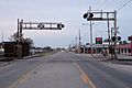
Hoxie is a city in Lawrence County, Arkansas, United States. It is located just south of Walnut Ridge. In 2020, about 2,598 people lived there.
Contents
History of Hoxie
Hoxie's School Integration Story
Before 1955, schools in Hoxie were separated. White students and Black students went to different schools. Black high school students had to travel far to Jonesboro for school. Younger Black students had only one teacher.
In 1954, a big court case called Brown v. Board of Education said that separate schools were not fair. This ruling meant schools had to integrate. In 1955, Hoxie's school leader, Kunkel Edward Vance, decided to integrate the schools. The school board agreed with him.
On July 11, 1955, Hoxie schools opened with African American students attending. Mr. Vance wanted all parts of the school, like restrooms and cafeterias, to be open to everyone. He believed it was the right thing to do and followed the law.
The first day went smoothly, and teachers and students got along well. However, Hoxie's decision to integrate attracted national attention. Photographers from Life Magazine came to document the event. After the magazine article was published, some people who did not want integration came to Hoxie.
These people tried to stop the school board's decision. They printed flyers with false claims and tried to cause trouble. A local farmer, Herbert Brewer, led a group that tried to get students to boycott the schools. About one-third of the white students did not attend school starting August 4, 1955.
A lawyer named Amis Guthridge also tried to stir up anger. He made strong statements against integration. Other people joined him, trying to make white parents afraid.
The Hoxie School Board took legal action against these people. They accused them of trespassing, threatening school staff, and organizing boycotts. In November 1955, Judge Thomas C. Trimble ruled that these groups had "planned and conspired" to stop integration.
In December 1955, the judge issued a permanent order against them. The U.S. Department of Justice and United States Attorney General Herbert Brownell supported the Hoxie School Board. This was the first time the Attorney General helped a school district trying to integrate. On October 25, 1956, the court decided in favor of the Hoxie School Board.
U.S. Attorney Osro Cobb later said that the situation in Hoxie was very tense. He noted that talking things out helped calm the situation. He believed it showed that even when people are very emotional, they can find solutions by working together for the good of the community.
In 2003, a film called Hoxie - The First Stand was made about these events. It won important awards like the Peabody Award.
Train Accident in Hoxie
On August 17, 2014, two Union Pacific freight trains crashed in Hoxie. This happened at 2:30 AM. Two people died in the accident.
About 500 people living nearby had to leave their homes for safety. A major road, U.S. 67, was closed for about a week. This was needed for cleanup and repairs after the crash.
Geography of Hoxie

Hoxie is located at 36°2′55″N 90°58′38″W / 36.04861°N 90.97722°W. The city covers about 4.0 square miles (10.4 square kilometers) of land.
Major Roads in Hoxie
Several important highways pass through Hoxie:
 U.S. 63
 U.S. 67
 U.S. 63 Business
 Highway 367
U.S. Highways 63 and 67 cross each other in Hoxie. U.S. 63 enters Arkansas from Missouri. It then goes southeast and connects with Interstate 55. U.S. 67 crosses Arkansas from southwest to northeast.
Two major railroads also have tracks that cross in Hoxie. The Burlington Northern-Santa Fe (BNSF) tracks run northwest-southeast. The Union Pacific (UP) tracks run north-south. This is similar to how tracks cross in Jonesboro.
Population of Hoxie
| Historical population | |||
|---|---|---|---|
| Census | Pop. | %± | |
| 1890 | 102 | — | |
| 1900 | 125 | 22.5% | |
| 1910 | 915 | 632.0% | |
| 1920 | 1,711 | 87.0% | |
| 1930 | 1,448 | −15.4% | |
| 1940 | 1,466 | 1.2% | |
| 1950 | 1,855 | 26.5% | |
| 1960 | 1,886 | 1.7% | |
| 1970 | 2,265 | 20.1% | |
| 1980 | 2,961 | 30.7% | |
| 1990 | 2,676 | −9.6% | |
| 2000 | 2,817 | 5.3% | |
| 2010 | 2,780 | −1.3% | |
| 2020 | 2,598 | −6.5% | |
| U.S. Decennial Census | |||
What the 2020 Census Shows
| Race | Number | Percentage |
|---|---|---|
| White (non-Hispanic) | 2,407 | 92.65% |
| Black or African American (non-Hispanic) | 14 | 0.54% |
| Native American | 10 | 0.38% |
| Asian | 3 | 0.12% |
| Pacific Islander | 1 | 0.04% |
| Other/Mixed | 138 | 5.31% |
| Hispanic or Latino | 25 | 0.96% |
In 2020, there were 2,598 people living in Hoxie. There were 1,186 households and 616 families.
What the 2010 Census Shows
In 2010, Hoxie had 2,780 people. There were 1,108 households and 797 families. The population density was about 707.5 people per square mile.
Most people in Hoxie were White (98.15%). A small percentage were Black or African American (0.46%). About 1.49% of the population was Hispanic or Latino.
About 36.0% of households had children under 18. About 53.6% were married couples. The average household had 2.54 people. The average family had 3.03 people.
The median age in the city was 34 years old. About 27.9% of the population was under 18. About 12.9% were 65 or older.
The median income for a household was $24,726. For a family, it was $30,085. About 24.2% of the population lived below the poverty line. This included 31.3% of those under 18.
Education in Hoxie
Students in Hoxie attend public schools run by the Hoxie School District. They can go all the way through to Hoxie High School. The school mascot is the Mustang. The school colors are green and white.
Famous People from Hoxie
- Billy Taylor, a talented football player.
- Miller Williams, a well-known poet.
- Raven Gates Gottschalk, a person who appeared on reality TV shows.
Images for kids
-
-
Location of Hoxie in Lawrence County, Arkansas.
See also
 In Spanish: Hoxie (Arkansas) para niños
