Greene County, Arkansas facts for kids
Quick facts for kids
Greene County
|
|
|---|---|

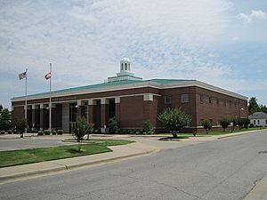
Courthouse in Paragould
|
|

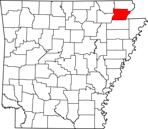
Location within the U.S. state of Arkansas
|
|
 Arkansas's location within the U.S. |
|
| Country | |
| State | |
| Founded | November 5, 1833 |
| Named for | Nathanael Greene |
| Seat | Paragould |
| Largest city | Paragould |
| Area | |
| • Total | 580 sq mi (1,500 km2) |
| • Land | 578 sq mi (1,500 km2) |
| • Water | 1.9 sq mi (5 km2) 0.3%% |
| Population
(2020)
|
|
| • Total | 45,736 |
| • Estimate
(2023)
|
46,743 |
| • Density | 78.9/sq mi (30.45/km2) |
| Time zone | UTC−6 (Central) |
| • Summer (DST) | UTC−5 (CDT) |
| Congressional district | 1st |
Greene County is a county located in the state of Arkansas. In 2020, about 45,736 people lived here. The main town and county seat (where the county government is) is Paragould. This town is built on a special landform called Crowley's Ridge. Greene County is part of the larger Jonesboro–Paragould Combined Statistical Area.
Contents
History of Greene County
The first person to settle in this area was Benjamin Crowley. He came from Kentucky in 1821. He built his home about 12 miles west of Paragould.
Greene County was officially created on November 5, 1833. It was made from parts of Lawrence County. At first, it also included parts of what are now Clay and Craighead counties. The county was named after Nathanael Greene. He was a hero from the American Revolutionary War.
The first county seat was Benjamin Crowley's home. By 1836, when Arkansas became a state, the county seat moved to a place called "Paris." This is not the same as the current Paris, Arkansas.
In 1848, a major highway was built through the area. The county seat then moved to Gainesville. Gainesville was known for being a bit wild back then. The county seat stayed there until 1883. Then, it moved to the new town of Paragould. People in Gainesville were not happy about this move. Some reports say shots were fired because people were so upset. The courthouse in Paragould was built in 1888. It is still standing in downtown Paragould today.
In the early 1900s, Clay, Greene, and Craighead counties had special rules. These rules made it very difficult for African Americans to live in these areas.
Geography of Greene County
Greene County covers about 580 square miles. Most of this area, about 578 square miles, is land. Only a small part, about 1.9 square miles (0.3%), is water.
Main Roads
Neighboring Counties
- Clay County (north)
- Dunklin County, Missouri (east)
- Craighead County (south)
- Lawrence County (southwest)
- Randolph County (northwest)
People in Greene County
| Historical population | |||
|---|---|---|---|
| Census | Pop. | %± | |
| 1840 | 1,586 | — | |
| 1850 | 2,593 | 63.5% | |
| 1860 | 5,843 | 125.3% | |
| 1870 | 7,573 | 29.6% | |
| 1880 | 7,480 | −1.2% | |
| 1890 | 12,908 | 72.6% | |
| 1900 | 16,979 | 31.5% | |
| 1910 | 23,852 | 40.5% | |
| 1920 | 26,105 | 9.4% | |
| 1930 | 26,127 | 0.1% | |
| 1940 | 30,204 | 15.6% | |
| 1950 | 29,149 | −3.5% | |
| 1960 | 25,198 | −13.6% | |
| 1970 | 24,765 | −1.7% | |
| 1980 | 30,744 | 24.1% | |
| 1990 | 31,804 | 3.4% | |
| 2000 | 37,331 | 17.4% | |
| 2010 | 42,090 | 12.7% | |
| 2020 | 45,736 | 8.7% | |
| 2023 (est.) | 46,743 | 11.1% | |
| U.S. Decennial Census 1790–1960 1900–1990 1990–2000 2010 |
|||
2020 Census Information
This table shows the different groups of people living in Greene County in 2020:
| Race | Number | Percentage |
|---|---|---|
| White (non-Hispanic) | 40,509 | 88.57% |
| Black or African American (non-Hispanic) | 926 | 2.02% |
| Native American | 138 | 0.3% |
| Asian | 181 | 0.4% |
| Pacific Islander | 287 | 0.63% |
| Other/Mixed | 2,099 | 4.59% |
| Hispanic or Latino | 1,596 | 3.49% |
In 2020, there were 45,736 people living in Greene County. There were 17,254 households and 12,280 families.
2010 Census Information
In 2010, there were 42,090 people in the county. Most people (95.4%) were White. About 0.6% were Black, 0.5% were Native American, and 0.3% were Asian. A very small number were Pacific Islander (less than 0.1%). About 1.1% of people were from two or more races. About 2.1% of the people were Hispanic or Latino.
Towns and Cities
Cities
Towns
Smaller Communities (Unincorporated)
These places are not officially cities or towns.
Townships
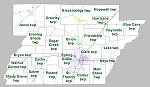
Counties in Arkansas are divided into smaller areas called townships. Here are the townships in Greene County: Townships in Arkansas are the divisions of a county. Each township includes unincorporated areas; some may have incorporated cities or towns within part of their boundaries. Arkansas townships have limited purposes in modern times. However, the United States Census does list Arkansas population based on townships (sometimes referred to as "county subdivisions" or "minor civil divisions"). Townships are also of value for historical purposes in terms of genealogical research. Each town or city is within one or more townships in an Arkansas county based on census maps and publications. The townships of Greene County are listed below; listed in parentheses are the cities, towns, and/or census-designated places that are fully or partially inside the township.
- Blue Cane
- Breckenridge (Lafe)
- Bryan
- Cache
- Clark (most of Paragould)
- Collier
- Crowley
- Evening Shade
- Friendship
- Hays
- Hopewell
- Hurricane (Marmaduke)
- Jones (Delaplaine)
- Lake
- Main Shore
- Poland
- Reynolds
- St. Francis (small part of Paragould)
- Salem
- Shady Grove
- Spring Grove (part of Paragould)
- Sugar Creek
- Union (Oak Grove Heights)
- Walnut Corner
Education
Here are the main school districts in Greene County:
- Greene County Technical School District
- Marmaduke School District
- Paragould School District
- This district includes the original Paragould School District. It also includes the Oak Grove School district, which joined in 1985. The Stanford School District also joined. The new district was first called the Northeast Arkansas School District. By 1997, its name became the Paragould School District.
- Rector School District
- The Greenway School District and the old Rector District joined together in 1984. They formed the Clay County Central School District. Later, this merged district became the Rector School District.
Former School Districts
- Delaplaine School District - This district joined with Greene County Technical in 2004.
See also
 In Spanish: Condado de Greene (Arkansas) para niños
 | Leon Lynch |
 | Milton P. Webster |
 | Ferdinand Smith |


