Craighead County, Arkansas facts for kids
Quick facts for kids
Craighead County
|
|||
|---|---|---|---|

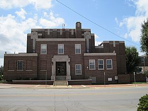
Craighead County Courthouse, Jonesboro
|
|||
|
|||

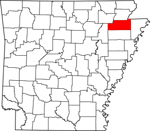
Location within the U.S. state of Arkansas
|
|||
 Arkansas's location within the U.S. |
|||
| Country | |||
| State | |||
| Founded | February 19, 1859 | ||
| Named for | Thomas Craighead | ||
| Seat | Jonesboro (western district); Lake City (eastern district) |
||
| Largest city | Jonesboro | ||
| Area | |||
| • Total | 713 sq mi (1,850 km2) | ||
| • Land | 707 sq mi (1,830 km2) | ||
| • Water | 5.5 sq mi (14 km2) 0.8%% | ||
| Population
(2020)
|
|||
| • Total | 111,231 | ||
| • Density | 156.00/sq mi (60.23/km2) | ||
| Time zone | UTC−6 (Central) | ||
| • Summer (DST) | UTC−5 (CDT) | ||
| Congressional district | 1st | ||
Craighead County is a county in the state of Arkansas. In 2020, about 111,231 people lived here. The county has two main offices, called county seats: Jonesboro and Lake City.
Craighead County became Arkansas's 58th county on February 19, 1859. It was named after Thomas Craighead, who was a state Senator. It is also known as a "dry county," which means selling alcoholic drinks is mostly not allowed there.
Craighead County is part of the larger Jonesboro–Paragould Combined Statistical Area.
Contents
History of Craighead County
This area was once claimed by different countries before it became part of the United States.
Early Claims and Ownership Changes
On April 9, 1682, a French explorer named René Robert Cavelier, Sieur de La Salle claimed this land for France. He named the entire area, which included all lands drained by the Mississippi River, "Louisiana" to honor King Louis XIV.
Later, in 1762, France and Spain signed a deal called the Treaty of Fontainebleau (1762). Because of a big war called the Seven Years' War, France gave the Louisiana territory west of the Mississippi River to Spain. So, Craighead County became a Spanish possession.
Spain controlled this land until October 1, 1800. Then, Napoleon Bonaparte of France made Spain give the territory back to France in a deal called the Third Treaty of San Ildefonso. Napoleon had big plans to create a huge French Empire in Louisiana. However, the Royal Navy of Britain stopped him from sending soldiers or settlers there.
The Louisiana Purchase
The United States worried that Napoleon might close the Mississippi River to American trade. President Thomas Jefferson wanted to buy a small area near the river's mouth to keep it open. But Napoleon, who needed money, offered to sell the entire Louisiana territory to the United States for about $23 million.
This deal, known as the Louisiana Purchase, was completed in 1803. This is how the land that would become Craighead County became part of the United States.
Forming Arkansas and Craighead County
The land remained part of the Louisiana Territory until the state of Louisiana joined the Union. After that, the area that is now Arkansas became part of the Missouri Territory.
In 1813, this area was included in a new section called Arkansas County. In 1815, Lawrence County was formed, and it covered most of what is now northern Arkansas. Modern Craighead County was partly in Arkansas County and partly in Lawrence County.
In 1819, the Arkansas Territory was officially formed.
By 1838, Poinsett County was created, and it included most of what is now Craighead County. People living in this area complained because the Poinsett County seat was too far away.
The Creation of Craighead County
In 1858, State Senator William A. Jones promised to help create a new county for the area. He won the election and pushed for a new county to be formed.
The new county was planned to use land from Greene, Mississippi, and Poinsett counties. It was first going to be named "Crowley County" after Crowley's Ridge, a land feature that runs through the county.
Senator Thomas Craighead, who represented Mississippi County, did not like the plan. He opposed it because the new county would take farmland from Mississippi County, which was important for taxes.
One day, while Senator Craighead was not in the Senate, Senator Jones changed the bill to name the county "Craighead County" instead. The Senate thought this was a good compromise and approved the bill. By the time Senator Craighead returned, the bill had already passed.
Craighead County was officially formed on February 19, 1859. To show their thanks, the citizens named the main county seat Jonesboro, after Senator Jones. Lake City, located across the St. Francis River, was added as a second county seat in 1883.
Geography
Craighead County covers about 713 square miles. Most of this area, about 707 square miles, is land, and 5.5 square miles (0.8%) is water. The most noticeable natural feature in the county is Crowley's Ridge.
Main Roads
Airport
The Jonesboro Municipal Airport serves the region.
Neighboring Counties
Craighead County shares borders with these counties:
- Greene County (north)
- Dunklin County, Missouri (northeast)
- Mississippi County (east)
- Poinsett County (south)
- Jackson County (west)
- Lawrence County (northwest)
People and Population (Demographics)
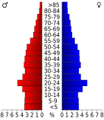
Demographics is the study of a population. It looks at things like how many people live somewhere, their ages, and their backgrounds.
| Historical population | |||
|---|---|---|---|
| Census | Pop. | %± | |
| 1860 | 3,066 | — | |
| 1870 | 4,577 | 49.3% | |
| 1880 | 7,037 | 53.7% | |
| 1890 | 12,025 | 70.9% | |
| 1900 | 19,505 | 62.2% | |
| 1910 | 27,627 | 41.6% | |
| 1920 | 37,541 | 35.9% | |
| 1930 | 44,740 | 19.2% | |
| 1940 | 47,200 | 5.5% | |
| 1950 | 50,613 | 7.2% | |
| 1960 | 47,303 | −6.5% | |
| 1970 | 52,068 | 10.1% | |
| 1980 | 63,239 | 21.5% | |
| 1990 | 68,956 | 9.0% | |
| 2000 | 82,148 | 19.1% | |
| 2010 | 96,443 | 17.4% | |
| 2020 | 111,231 | 15.3% | |
| 2023 (est.) | 113,993 | 18.2% | |
| U.S. Decennial Census 1790–1960 1900–1990 1990–2000 2010–2016 2020 census |
|||
2020 Census Information
The 2020 United States census counted 111,231 people living in Craighead County. There were 41,409 households and 27,829 families.
| Race | Number | Percentage |
|---|---|---|
| White (not Hispanic) | 79,137 | 71.15% |
| Black or African American (not Hispanic) | 18,331 | 16.48% |
| Native American | 270 | 0.24% |
| Asian | 1,684 | 1.51% |
| Pacific Islander | 54 | 0.05% |
| Other/Mixed | 5,028 | 4.52% |
| Hispanic or Latino | 6,727 | 6.05% |
Education in Craighead County
Craighead County has many schools for students of all ages.
Public Schools
There are eight public school districts in Craighead County, with many elementary and high schools:
- Bay School District, including Bay High School (Bay)
- Brookland School District, including Brookland High School (Brookland)
- Buffalo Island Central School District, including Buffalo Island Central High School (Monette)
- Greene County Technical School District (its high school is in another county)
- Jonesboro School District, including Jonesboro High School (Jonesboro)
- Nettleton School District, including Nettleton High School (Jonesboro)
- Riverside School District, including Riverside High School (Lake City)
- Valley View School District, including Valley View High School (Jonesboro)
- Westside Consolidated School District, including Westside High School (near Jonesboro)
Private Schools
Some private schools in the county include:
- Ridgefield Christian School (Jonesboro) for grades PK-12
- Blessed Sacrament School (Jonesboro) for grades KG-6
- Concordia Christian Academy (Jonesboro) for grades PK-6
- First Presbyterian Preschool & Kindergarten (Jonesboro) for grades PK-KG
- Montessori School of Jonesboro (Jonesboro) for grades PK-KG
Colleges and Universities
For education after high school, students can attend:
- Arkansas State University
- Arkansas State University Newport - Jonesboro Technical Campus
Communities in Craighead County
Craighead County has several cities, towns, and other communities.
Cities
Towns
Census-Designated Places (CDPs)
Other Unincorporated Communities
These are smaller communities that are not officially cities or towns:
- Childress
- Gibson
- Goobertown
- Herman
- Lester
- Lunsford
- Otwell
Townships
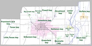
Townships are smaller areas within a county, often used for local administration. Townships in Arkansas are the divisions of a county. Each township includes unincorporated areas; some may have incorporated cities or towns within part of their boundaries. Arkansas townships have limited purposes in modern times. However, the United States Census does list Arkansas population based on townships (sometimes referred to as "county subdivisions" or "minor civil divisions"). Townships are also of value for historical purposes in terms of genealogical research. Each town or city is within one or more townships in an Arkansas county based on census maps and publications. The townships of Craighead County are listed below; listed in parentheses are the cities, towns, and/or census-designated places that are fully or partially inside the township.
- Big Creek (Bono)
- Black Oak (Black Oak) (Caraway)
- Brookland (Brookland)
- Buffalo (Monette)
- Gilkerson (part of Jonesboro)
- Greenfield (small part of Jonesboro)
- Herndon
- Jonesboro (largest portion of Jonesboro)
- Lake City (Lake City)
- Lester
- Little Texas (small part of Cash)
- Maumelle (Bay, part of Jonesboro)
- Nettleton (part of Jonesboro)
- Powell
- Prairie
- Promised Land (Egypt)
- Taylor
- Texas (majority of Cash)
See also
 In Spanish: Condado de Craighead para niños
 | Calvin Brent |
 | Walter T. Bailey |
 | Martha Cassell Thompson |
 | Alberta Jeannette Cassell |


