Egypt, Arkansas facts for kids
Quick facts for kids
Egypt, Arkansas
|
|
|---|---|

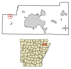
Location of Egypt in Craighead County, Arkansas
|
|
| Country | United States |
| State | Arkansas |
| County | Craighead |
| Area | |
| • Total | 0.34 sq mi (0.87 km2) |
| • Land | 0.34 sq mi (0.87 km2) |
| • Water | 0.00 sq mi (0.00 km2) |
| Elevation | 249 ft (76 m) |
| Population
(2020)
|
|
| • Total | 113 |
| • Density | 336.31/sq mi (129.71/km2) |
| Time zone | UTC-6 (Central (CST)) |
| • Summer (DST) | UTC-5 (CDT) |
| ZIP code |
72427
|
| Area code(s) | 870 |
| FIPS code | 05-20920 |
| GNIS feature ID | 2406428 |
Egypt is a small town located in Craighead County, Arkansas, United States. In 2020, about 113 people lived there. It is part of the larger Jonesboro, Arkansas area.
Contents
History of Egypt, Arkansas
Egypt, Arkansas, is a small town found in Craighead County, close to the Cache River. It was started in 1898 by business people from New York. They came because there was a lot of timber (trees for wood) in the area.
How the Town Grew
A special narrow railway was built by the Sedgwick Tie and Timber Company. This railway connected Egypt to a bigger train line, which helped the town grow. In the 1930s and 1950s, Egypt had several stores, a cotton gin, a school, and churches.
Why Egypt Didn't Grow Bigger
Even with these businesses, Egypt never became a very large town. This was because it was far from the main railway line and major highways. In 1942, a pumping station was built nearby for the Big Inch oil pipeline, which moved oil across the country.
Decline and Modern Day
The town started to get smaller after most of the timber was cut down. Also, local schools joined together, meaning fewer schools were needed in Egypt itself. The town officially became an incorporated town in 1984.
Geography of Egypt
Egypt is located in the western part of Craighead County. The town got its unique name from one of its first settlers, a noblewoman from Wales named Victoria Eyshept. Because of her strong accent, people thought she was saying "Egypt", and the name stuck!
Size and Location
According to the United States Census Bureau, the town is quite small. It covers an area of about 0.9 square kilometers (or 0.34 square miles), and all of this area is land.
Roads and Travel
Only one main road goes through Egypt. This is Arkansas Highway 91, which crosses Craighead County Road 192 right in the middle of town.
Population of Egypt
| Historical population | |||
|---|---|---|---|
| Census | Pop. | %± | |
| 1990 | 123 | — | |
| 2000 | 101 | −17.9% | |
| 2010 | 112 | 10.9% | |
| 2020 | 113 | 0.9% | |
| U.S. Decennial Census | |||
In the year 2000, there were 101 people living in Egypt. Most of the people living in the town were White (97.03%). A small number (2.97%) were from two or more racial backgrounds. About 0.99% of the people were Hispanic or Latino.
The population included people of all ages. About 24.8% were under 18 years old, and 27.7% were 65 years old or older. The average age in the town was 43 years.
Education in Egypt
Students living in Egypt go to schools that are part of the Westside Consolidated School District. This school district was created in 1966 when the Egypt school district joined it. The high school for students from Egypt is Westside High School.
See also
 In Spanish: Egypt (Arkansas) para niños
 | Ernest Everett Just |
 | Mary Jackson |
 | Emmett Chappelle |
 | Marie Maynard Daly |

