
Arkansas Territory facts for kids
Quick facts for kids Arkansas Territory |
|||||||||||
|---|---|---|---|---|---|---|---|---|---|---|---|
| Organized incorporated territory of the United States | |||||||||||
| 1819–1836 | |||||||||||
 |
|||||||||||
| Capital |
|
||||||||||
| Area | |||||||||||
| • Coordinates | 34°44′10″N 92°19′52″W / 34.73611°N 92.33111°W | ||||||||||
| Government | |||||||||||
| • Type | Organized incorporated territory | ||||||||||
| President | |||||||||||
|
• 1819–1825
|
James Monroe | ||||||||||
|
• 1825–1829
|
John Quincy Adams | ||||||||||
|
• 1829–1836
|
Andrew Jackson | ||||||||||
| Governor | |||||||||||
|
• 1819–1824
|
James Miller | ||||||||||
|
• 1825–1828
|
George Izard | ||||||||||
|
• 1829–1835
|
John Pope | ||||||||||
|
• 1835–1836
|
William Fulton | ||||||||||
| Legislature | General Assembly | ||||||||||
|
• Upper house
|
Legislative Council | ||||||||||
|
• Lower house
|
House of Representatives | ||||||||||
| History | |||||||||||
|
• Affirmed by Congress
|
2 March 1819 | ||||||||||
|
• Officially became territory
|
July 4, 1819 | ||||||||||
| June 30, 1834 | |||||||||||
| May 6, 1828 | |||||||||||
|
• Statehood of Arkansas
|
15 June 1836 | ||||||||||
|
|||||||||||
| Today part of | United States | ||||||||||
.svg)

The Arkansas Territory was a special area of the United States that was not yet a state. It existed from July 4, 1819, until June 15, 1836. On that date, the area became the State of Arkansas. The first capital city of the territory was Arkansas Post (from 1819 to 1821). Later, the capital moved to Little Rock (from 1821 to 1836).
Contents
Understanding the Name: Arkansas
The name "Arkansas" has been spelled and said in different ways over time. When the territory was first created on March 2, 1819, it was called the "Territory of Arkansaw." However, when it became a state in 1836, it was named "Arkansas."
For many years, people argued about how to say "Arkansas." Some said it with a silent "s" at the end, like "Ar-kan-saw." Others said it with the "s" sound, like "Ar-kan-sas."
In 1881, the government of Arkansas decided to settle the debate. They passed a rule saying the correct way to say the state's name is "Ar-kan-saw," with the "s" being silent. They wanted to honor the way the French explorers first heard the name from Native Americans.
- The name should have three syllables.
- The "s" at the end should not be pronounced.
- The "a" in each syllable should sound like the "a" in "father."
- The stress should be on the first and last syllables.
Even today, people in Kansas often say the Arkansas River with the "s" sound, similar to how they say the name of their own state.
History of the Arkansas Territory
The Arkansas Territory was officially created on March 2, 1819, by the United States Congress. It was formed from the southern part of the Missouri Territory. The territory officially began on July 4, 1819.
Changing Borders of the Territory
When the Arkansas Territory was first formed, it included a large area. This included all of what is now the state of Oklahoma south of a certain line (36 degrees 30 minutes north latitude).
However, the territory's western border changed twice.
- On November 15, 1824, a part of the western territory was removed.
- On May 6, 1828, another western part was removed.
These changes made the Arkansas Territory about the same size as the present-day state of Arkansas.
The Fort Smith Border
The original plan was for the western border of Missouri to go straight south to the Red River. But during talks with the Choctaw Native American tribe in 1820, Andrew Jackson accidentally gave away more land from the Arkansas Territory than intended.
Later, in 1824, the Choctaw agreed to move further west. But they only moved "100 paces" from the military post at Belle Point. This is why the border near Fort Smith has a bend in it.
Original Counties
When the territory was first established, it had nine counties:
- Arkansas
- Clark
- Crawford
- Hempstead
- Independence
- Lawrence
- Miller
- Phillips
- Pulaski
Population of the Arkansas Territory
The population of the Arkansas Territory grew during its time. A "census" is a count of how many people live in an area.
In the 1820 United States census, only 7 counties reported their populations. By the 1830 United States census, 23 counties in the Arkansas Territory reported their population numbers.
It's important to know that these census counts did not include Native Americans. The 1820 count did include 1,617 enslaved people. While a count of the Cherokee tribe was planned in 1818, it never happened. Instead, in 1819, officials estimated there were 5,000 Cherokee in Arkansas, even though the Cherokee Nation thought there were only about 3,500. The Quapaw tribe was counted at 455 people in the mid-1820s.
| 1830 Rank |
County | 1820 Population |
1830 Population |
|---|---|---|---|
| 1 | Lawrence | 5,602 | 2,806 |
| 2 | Hempstead | 2,248 | 2,512 |
| 3 | Crawford | – | 2,440 |
| 4 | Pulaski | 1,923 | 2,395 |
| 5 | Washington | – | 2,182 |
| 6 | Independence | – | 2,031 |
| 7 | St. Francis | – | 1,505 |
| 8 | Pope | – | 1,483 |
| 9 | Arkansas | 1,260 | 1,426 |
| 10 | Clark | 1,040 | 1,369 |
| 11 | Crittenden | – | 1,272 |
| 12 | Izard | – | 1,266 |
| 13 | Chicot | – | 1,165 |
| 14 | Phillips | 1,201 | 1,152 |
| 15 | Conway | – | 982 |
| 16 | Jefferson | – | 772 |
| 17 | Lafayette | – | 748 |
| 18 | Union | – | 640 |
| 19 | Sevier | – | 634 |
| 20 | Monroe | – | 461 |
| 21 | Hot Spring | – | 458 |
| 22 | Miller | 999 | 356 |
| 23 | Jackson | – | 333 |
| Arkansas Territory | 14,273 | 30,388 |
Law and Government
The Arkansas Territory had its own government, even though it wasn't a state yet.
- Territorial Secretary: Robert Crittenden was the main secretary for the territory until 1829. He acted as the de facto (meaning "in practice" or "unofficial") governor. He helped prepare Arkansas to become a state.
- Fort Smith's Role: Until present-day Oklahoma became a state, Fort Smith was the main legal authority for the Indian Territory. This meant it was in charge of legal matters for the Native American tribes in that area.
- The Army's Role: The Army was responsible for handling issues and relationships with the different Native American Nations in the territory.
Images for kids
-
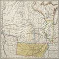
Geographical, Statistical and Historical Map of Arkansas Territory, after Stephen Harriman Long, 1822
.jpg)
See also
 In Spanish: Territorio de Arkansas para niños
