Clark County, Arkansas facts for kids
Quick facts for kids
Clark County
|
|
|---|---|

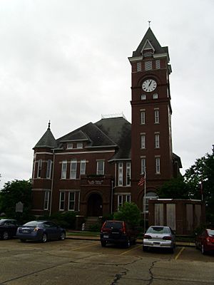
Clark County Courthouse in Arkadelphia
|
|

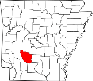
Location within the U.S. state of Arkansas
|
|
 Arkansas's location within the U.S. |
|
| Country | |
| State | |
| Founded | December 15, 1818 |
| Named for | William Clark |
| Seat | Arkadelphia |
| Largest city | Arkadelphia |
| Area | |
| • Total | 883 sq mi (2,290 km2) |
| • Land | 866 sq mi (2,240 km2) |
| • Water | 17 sq mi (40 km2) 1.9%% |
| Population
(2020)
|
|
| • Total | 21,446 |
| • Density | 24.288/sq mi (9.378/km2) |
| Time zone | UTC−6 (Central) |
| • Summer (DST) | UTC−5 (CDT) |
| Congressional district | 4th |
Clark County is a place in the south-central part of Arkansas, a state in the USA. A "county" is like a smaller area within a state, often with its own local government. In 2020, about 21,446 people lived here. The main town, or "county seat," where the county government is located, is Arkadelphia. The whole county is part of the Arkadelphia "Micropolitan Statistical Area," which means it's a smaller city area with close ties to its surrounding communities.
Contents
History of Clark County
Clark County was one of the very first counties in Arkansas. It was officially formed on December 15, 1818. At that time, Arkansas was not yet a state; it was part of the Missouri Territory. Two other counties, Hempstead and Pulaski, were also created on the same day.
Who was Clark County named after?
The county is named after William Clark. He was a famous explorer who traveled across America with Meriwether Lewis. At the time Clark County was formed, William Clark was the Governor of the Missouri Territory.
When did Pike County form?
Later, on November 1, 1833, a new county called Pike County was created. It was made from parts of western Clark County and northern Hempstead County. Pike County was named after another explorer, Zebulon Pike.
When was Arkadelphia chosen as the county seat?
In 1842, the town of Arkadelphia was chosen to be the county seat for Clark County.
Clark County in the 20th Century and Today
From 1920 to 1960, the number of people living in Clark County went down. This happened for a few reasons.
Why did the population decline?
One reason was problems with farming, especially cotton. A tiny insect called the boll weevil attacked cotton plants, making it harder for farmers to grow crops. Also, new machines made farming easier, so fewer workers were needed.
Many African-American families, who often worked on farms, moved away during this time. This was part of a big movement called the Great Migration. They left the rural South to find better jobs and escape unfair rules known as Jim Crow laws. Some moved to cities in the North and Midwest. Later, during and after World War II, some moved to the West Coast for jobs in factories that made things for the war.
What happened to the lumber industry?
The lumber industry, which involved cutting down trees and making wood products, also became less active. Several companies that had sawmills in Clark County closed down or moved. For example, the founders of the lumber town Graysonia, Arkansas moved their company to Oregon.
How did the economy change?
In the 1980s, some manufacturing businesses in the county faced difficulties. However, in the 1970s, something new helped the county's economy. The DeGray Dam and Lake were built on the Caddo River. This created new places for people to visit and enjoy outdoor activities. Today, tourism and recreation are very important parts of Clark County's economy.
Geography of Clark County
Clark County covers a total area of 883 square miles. Most of this area, 866 square miles, is land. The remaining 17 square miles, which is about 1.9% of the total area, is water.
Major Roads in Clark County
Several important roads pass through Clark County, making it easy to travel to and from the area:
 Interstate 30
 U.S. Highway 67
 Highway 7
 Highway 8
 Highway 26
 Highway 51
 Highway 53
Neighboring Counties
Clark County shares its borders with several other counties:
- Hot Spring County (to the northeast)
- Dallas County (to the east)
- Ouachita County (to the southeast)
- Nevada County (to the southwest)
- Pike County (to the west)
- Montgomery County (to the northwest)
Clark County Population Information
The population of Clark County has changed over many years, as shown in the table below.
| Historical population | |||
|---|---|---|---|
| Census | Pop. | %± | |
| 1830 | 1,369 | — | |
| 1840 | 2,309 | 68.7% | |
| 1850 | 4,070 | 76.3% | |
| 1860 | 9,735 | 139.2% | |
| 1870 | 11,953 | 22.8% | |
| 1880 | 15,771 | 31.9% | |
| 1890 | 20,997 | 33.1% | |
| 1900 | 21,289 | 1.4% | |
| 1910 | 23,686 | 11.3% | |
| 1920 | 25,632 | 8.2% | |
| 1930 | 24,932 | −2.7% | |
| 1940 | 24,402 | −2.1% | |
| 1950 | 22,998 | −5.8% | |
| 1960 | 20,950 | −8.9% | |
| 1970 | 21,537 | 2.8% | |
| 1980 | 23,326 | 8.3% | |
| 1990 | 21,437 | −8.1% | |
| 2000 | 23,546 | 9.8% | |
| 2010 | 22,995 | −2.3% | |
| 2020 | 21,446 | −6.7% | |
| 2023 (est.) | 21,274 | −7.5% | |
| U.S. Decennial Census 1790–1960 1900–1990 1990–2000 2010 |
|||
Clark County in 2020
The 2020 United States census counted 21,446 people living in Clark County. There were 8,446 households (groups of people living together) and 5,253 families.
The table below shows the different racial groups that make up the population of Clark County, based on the 2020 census:
| Race | Num. | Perc. |
|---|---|---|
| White (non-Hispanic) | 14,093 | 65.71% |
| Black or African American (non-Hispanic) | 5,068 | 23.63% |
| Native American | 76 | 0.35% |
| Asian | 150 | 0.7% |
| Pacific Islander | 16 | 0.07% |
| Other/Mixed | 951 | 4.43% |
| Hispanic or Latino | 1,092 | 5.09% |
Culture in Clark County
For many years, Clark County was a "dry county." This meant that selling alcohol was not allowed. This rule had been in place since 1943. However, in 2011, people in Clark County voted to change this. Now, alcohol can be sold in stores and restaurants throughout the county.
Communities in Clark County
Clark County has several towns and cities where people live.
Cities in Clark County
- Amity
- Arkadelphia (This is the county seat, the main town for the county government.)
- Gurdon
Towns in Clark County
Unincorporated Communities
These are smaller places that are not officially part of a city or town:
Townships
Clark County is a bit different from most other counties in Arkansas. It has only one single township called Caddo. This one township covers the entire county.
Townships in Arkansas are the divisions of a county. Each township includes unincorporated areas; some may have incorporated cities or towns within part of their boundaries. Arkansas townships have limited purposes in modern times. However, the United States Census does list Arkansas population based on townships (sometimes referred to as "county subdivisions" or "minor civil divisions"). Townships are also of value for historical purposes in terms of genealogical research. Each town or city is within one or more townships in an Arkansas county based on census maps and publications. The townships of Clark County are listed below; listed in parentheses are the cities, towns, and/or census-designated places that are fully or partially inside the township.
- Caddo
Famous People from Clark County
Clark County has been home to several notable people:
- Daniel Davis: An actor best known for playing "Niles the butler" in the TV show The Nanny. He was born in Gurdon.
- Jody Evans: A country music singer who started his career in Clark County. He also works for the Arkadelphia Police Department.
- Cliff Harris: A football player who played for the Dallas Cowboys in the NFL. He played college football for the Ouachita Baptist University team.
- Bob C. Riley: A politician who was born and grew up in Arkadelphia. He was the Lieutenant Governor of Arkansas from 1971 to 1975.
- Jerry Thomasson: A politician and state representative who was born and raised in Arkadelphia.
- Billy Bob Thornton: A famous film actor who grew up in Alpine.
See also
 In Spanish: Condado de Clark (Arkansas) para niños
 | Aurelia Browder |
 | Nannie Helen Burroughs |
 | Michelle Alexander |


