Arkansas Highway 51 facts for kids
Quick facts for kids
Highway 51 |
||||
|---|---|---|---|---|
 |
||||
| Route information | ||||
| Maintained by AHTD | ||||
| Existed | April 1, 1926–present | |||
| Section 1 | ||||
| Length | 57.37 mi (92.33 km) | |||
| South end | ||||
| North end | ||||
| Section 2 | ||||
| Length | 7.92 mi (12.75 km) | |||
| South end | ||||
| North end | ||||
| Location | ||||
| Counties: | Clark, Hot Spring | |||
| Highway system | ||||
| Arkansas Highway System Interstates • US • State Business • Spurs • Scenic
|
||||
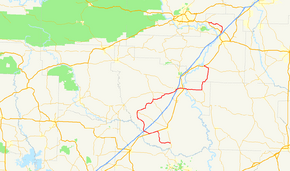
Highway 51 (also called AR 51 or Hwy. 51) is the name for two important roads in Southwest Arkansas. These roads go from south to north. One road is about 53 miles (85 km) long. It starts near Whelen Springs and goes north to US Highway 67 in Donaldson.
The second road is shorter, about 8 miles (13 km) long. It runs next to US 270 near Malvern. The Arkansas Department of Transportation (ArDOT) takes care of both parts of Highway 51.
A special part of Highway 51 in Clark County is very old. It is about 4 miles (6 km) long and is listed in the National Register of Historic Places. This means it is an important historical site.
Contents
Exploring Highway 51
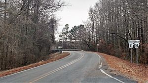
Both parts of Highway 51 are quiet, two-lane roads. They wind through the Piney Woods area of Southwest Arkansas. These roads are not part of the National Highway System. This system includes roads that are very important for the country's economy, defense, and travel.
The ArDOT looks after Highway 51, just like all other state roads. They keep track of how many cars use the roads. They use something called "average annual daily traffic" (AADT). This helps them guess how many vehicles use a road on an average day.
From Whelen Springs to Donaldson
Highway 51 starts in southern Clark County. It begins at Highway 53, close to Whelen Springs. The road goes through pine forests in the Arkansas Timberlands region. It is a two-lane road, except for a few miles inside the city of Arkadelphia.
The road first goes west, then turns north after a place called Sycamore. It crosses McNeeley Creek two times. Highway 51 then crosses the Union Pacific Railroad tracks. It also crosses an old road path near Beirne, which used to be a small town with a mill.
North of Beirne, Highway 51 shares a path with US Highway 67 (US 67). This is called a "concurrency" when two roads use the same path. After less than two miles, Highway 51 turns north away from US 67. Highway 51 then meets Interstate 30 (I-30) at an exit. It continues north through Burtsell.
The highway then runs next to the Caddo Valley Railroad and South Fork Terre Noir Creek. It crosses both of these near Okolona. In Okolona, the road passes the historic Okolona Colored High School Gymnasium. This building is listed on the National Register of Historic Places. Highway 51 then meets Highway 182.
Highway 51 leaves Okolona and briefly shares a path with Highway 53. They cross Terre Noir Creek near Holly Grove. Highway 51 then turns east towards Arkadelphia. It passes the Terre Noire Natural Area, which has special grasslands and woodlands. Highway 51 is where Highway 26 ends. It also passes the Bozeman House before entering Arkadelphia.
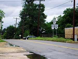
In Arkadelphia, Highway 51 becomes Hollywood Road. It passes Magnolia Manor. Then it meets Highway 8. These two roads share a path going east. They cross I-30 at another exit. Highway 8 and Highway 51 enter Arkadelphia as Pine Street. This area has both shops and homes. They then meet US 67 and Highway 7 (Tenth Street).
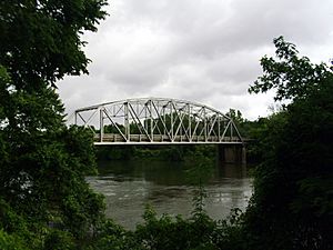
These four roads share a path going south on Tenth Street for two blocks. Then they turn onto Caddo Street and head east towards downtown Arkadelphia. They pass the historic Clark County Library. At Sixth Street, US 67 turns south. The three state highways continue east. They cross the Ouachita River on the Ouachita River Bridge. Soon after the bridge, Highway 7 and Highway 8 turn south towards Griffithtown.
Highway 51 continues east to Joan. Here, it meets Highway 128. The highway then turns north and enters Hot Spring County. It goes through Brown Springs. Then it is where Highway 222 ends, east of Donaldson. Highway 51 goes through Donaldson as Bryant Drive. It ends at an intersection with US 67.
In 2016, traffic counts showed that most of Highway 51 is a very quiet local road. This means fewer than 400 cars use it each day. This is true except for the areas around Arkadelphia.
The Malvern Section
A second part of Highway 51 starts at US 270. This is between Rockport and Malvern. It goes north through Rockport. Then it turns west towards Butterfield and Magnet Cove. West of Magnet Cove, this part of the highway ends at US 270.
The most traffic on this section was near Rockport, with about 3,200 cars per day. Near the western end, the traffic dropped to 1,400 cars per day.
History of Highway 51
Highway 51 was created in 1926. It was part of the first numbering system for Arkansas state highways. It was a road between US 67 and Arkadelphia in Clark County.
Near Beirne, an old part of the road is now called Clark County Road 12. Along this old road, the McNeely Creek Bridge is listed on the National Register of Historic Places. East of Arkadelphia, Highway 51 used to cross the Ouachita River on a historic bridge. This bridge was closed to cars in 2018 when a new bridge opened.
|
Arkansas 51, Old, Curtis to Gum Springs
|
|
Historic section of Highway 51
|
|
| Lua error in Module:Location_map at line 420: attempt to index field 'wikibase' (a nil value). | |
| Area | 9.5 acres (3.8 ha) |
|---|---|
| Built | 1931 |
| Built by | D.H. Dalton Co. |
| MPS | Arkansas Highway History and Architecture MPS |
| NRHP reference No. | 03001457 |
| Added to NRHP | January 21, 2004 |
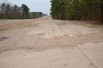
Between Curtis and Gum Springs, there is a 4-mile (6 km) long section of concrete road. It was built in 1931. This was part of the original Highway 51 that connected Little Rock with Texarkana. This old road was used until the current US 67 was built in 1965. This section of the road was added to the National Register of Historic Places in 2004.
Road Connections
Mile markers reset when roads share a path.
| County | Location | Mile | Roads intersected | Notes | |||
|---|---|---|---|---|---|---|---|
| Clark | | 0.00 | 0.00 | Southern start of the highway | |||
| | 8.18– 0.00 |
13.16– 0.00 |
|||||
| | 2.42 | 3.89 | |||||
| Okolona | 10.24 | 16.48 | Western end of AR 182 | ||||
| | 18.15– 18.99 |
29.21– 30.56 |
Officially designated exception | ||||
| | 24.24 | 39.01 | Eastern end of AR 26 | ||||
| Arkadelphia | 28.91 | 46.53 | AR 8 joins here | ||||
| 29.09 | 46.82 | ||||||
| 31.31 | 50.39 | US 67 and AR 7 join here | |||||
| 0.00 | 0.00 | US 67 leaves here | |||||
| 0.38– 0.47 |
0.61– 0.76 |
Bridge over the Ouachita River | |||||
| | 1.57 | 2.53 | AR 7 and AR 8 leave here | ||||
| Joan | 6.74 | 10.85 | Eastern end of AR 128 | ||||
| Hot Spring | | 15.83 | 25.48 | Western end of AR 222 | |||
| Donaldson | 17.35 | 27.92 | Eastern end of AR 51Y | ||||
| 17.88 | 28.78 | Northern end of the highway | |||||
| Gap in route | |||||||
| Rockport–Malvern line | 0.00 | 0.00 | Southern start of this section | ||||
| Magnet Cove | 7.92 | 12.75 | Northern end of this section | ||||
| 1.000 mi = 1.609 km; 1.000 km = 0.621 mi | |||||||
 | Janet Taylor Pickett |
 | Synthia Saint James |
 | Howardena Pindell |
 | Faith Ringgold |


