
Geography of Arkansas facts for kids

The geography of Arkansas is super diverse! This amazing state has everything from tall mountains and wide river valleys to thick forests, sparkling lakes, and swampy bayous. You'll also find busy cities here. For example, Hot Springs National Park is famous for its natural hot springs, which people once believed had healing powers. And Crowley's Ridge is a unique hill that stands out from the flat lands around it.
Arkansas is home to many important rivers. The Buffalo National River flows through The Ozarks and is a popular spot for visitors. It became America's first national river in 1972 after many people worked hard to protect it from being dammed. The Arkansas River enters the state near Van Buren and winds its way southeast through Little Rock before joining the mighty Mississippi River. This river is very important for moving goods by barge. Other big rivers include the Ouachita River, Saline River, White River, St. Francis River, and the Red River.
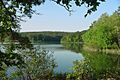
You'll also find many man-made lakes across Arkansas. Lots of these lakes are part of state parks or wildlife areas, making them great places for outdoor fun. Some popular lakes for recreation include Bull Shoals Lake, DeGray Lake, Lake Dardanelle, Lake Ouachita, Beaver Lake, Table Rock Lake, Greers Ferry Lake, and Lake Hamilton and Lake Catherine.
The The Ozarks is a large mountainous area in northwest Arkansas. This region includes the Boston Mountains, which have some of the highest peaks in the Ozarks.
Contents
Where is Arkansas Located and How Big is It?

Arkansas is located in the southeastern part of the United States. It's part of a group of states called the West South Central region. Arkansas covers about 53,179 square miles (137,733 square kilometers), making it the 29th largest state in the country.
Arkansas shares its borders with six other U.S. states:
- Missouri to the north
- Tennessee and Mississippi across the Mississippi River to the east
- Louisiana to the south
- Oklahoma to the west
- Texas to the southwest
Arkansas became part of the United States in 1803 as part of the Louisiana Purchase. Over time, its borders changed until they became what they are today in the 1840s.
Exploring Arkansas's Natural Regions
Arkansas has many different natural areas, each with its own unique features. These include:
- The Ozarks
- Ouachita Mountains
- Arkansas River Valley
- Gulf Coastal Plain
- Crowley's Ridge
- The Arkansas Delta
- Arkansas Timberlands
- Central Arkansas
People in Arkansas often describe themselves as being from one of five main areas: northwest, southwest, northeast, southeast, or central Arkansas. These areas aren't strictly defined by county lines.
Northwest Arkansas: Mountains and Forests

Northwest Arkansas is home to the southern part of the Ozarks. This includes the steep Boston Mountains and the gentler Springfield Plateau. These mountains are covered in thick forests, mostly with oak and hickory trees. Less than a quarter of this land has been cleared for farming.
The Ozark National Forest protects about 1.2 million acres (4,900 square kilometers) of land here. It also includes Mount Magazine, which is Arkansas's highest point, located in Mount Magazine State Park. This region also has the Arkansas River Valley, with popular tourist spots like Mount Nebo, Mount Magazine, Petit Jean Mountain, and Lake Dardanelle.
Many natural areas are protected, like the Buffalo National River, Bull Shoals–White River State Park, and Hobbs State Park – Conservation Area.
The main cities in Northwest Arkansas are in the Fayetteville–Springdale–Rogers Metropolitan Area and the Fort Smith metropolitan area. The rest of the region is mostly mountains with fewer people. The Ozark culture is strong here, with events like the Ozark Folk Festival in Mountain View. The Ozark Folk Center works to keep the region's folk heritage alive. Other cultural places include Crystal Bridges Museum of American Art in Bentonville and the University of Arkansas in Fayetteville.
Northeast Arkansas: Flat Lands and History

Northeast Arkansas is generally the area east of the Ozark Mountains and north of Interstate 40. This land is usually flat, fertile, and sometimes swampy, often called the Arkansas Delta. The one exception is Crowley's Ridge, a unique hill that rises about 200 feet (61 meters) above the flat delta lands.
Crowley's Ridge is more populated than the delta, with cities like Jonesboro, Paragould, Forrest City, and Wynne. Important rivers here include the Cache River, St. Francis River, and the Black River. Protected areas include Cache River National Wildlife Refuge and Lake Charles State Park.
Visitors can learn about Native American history at places like the Nodena site and Parkin Archaeological State Park. After settlers arrived, much of this area grew cotton. After the Civil War, farming changed, but plantation owners still held a lot of power. You can learn about this history at the Southern Tenant Farmers Union Museum. Rivers were like highways in the past, and old steamboat towns like Jacksonport State Park have been restored. Davidsonville Historic State Park shows what one of the state's first towns was like. The main city in this region is Jonesboro.
Southeast Arkansas: Forests and Farmland

Southeast Arkansas is generally the area east of Little Rock and south of Interstate 40. Like Northeast Arkansas, this region is mostly flat, fertile, and sometimes swampy, also part of the Arkansas Delta. It's not very populated, and its economy mostly relies on farming.
The western part of Southeast Arkansas has thick pine and cypress forests, known as the Piney Woods. Logging and farming are big industries here. Cities in this region include Pine Bluff, Stuttgart, Monticello, Warren, and Crossett. Major waterways are the Arkansas River, Bayou Bartholomew, Mississippi River, and the White River. Protected areas include Cane Creek State Park and Lake Chicot State Park.
The flat land and rich soil have always been important here, first for Native Americans and later for settlers. Arkansas Post was even the territorial capital. Many wealthy plantation owners grew cotton here before the Civil War. After the war, farming practices changed, but the powerful families often kept workers in poverty. In the 1950s, machines took over much of the farm work, causing many people to leave the region to find jobs. Because of this, the population and economies in much of Southeast Arkansas have continued to shrink. The main city is Pine Bluff.
Southwest Arkansas: Lakes and Hot Springs
Southwest Arkansas is largely covered by a dense pine, hickory, and oak forest called the Piney Woods. A lot of this land is protected within the Ouachita National Forest. The region is dotted with man-made lakes, such as Lake Ouachita, Lake Hamilton, Millwood Lake, and DeGray Lake.
The main cities include Hot Springs, which is a popular tourist spot. It's famous for its natural hot springs, which are protected in Hot Springs National Park. Hot Springs also has the Oaklawn Park racing resort and many historic buildings. Texarkana is another important city, located right on the border with Texas. Most of Southwest Arkansas has few people, with small towns spread out along roads that wind through pine trees.
Arkansas's Climate: Hot Summers and Storms

Arkansas generally has a humid subtropical climate. This means it has hot, humid summers and winters that are usually mild to cool, with a bit less rain. Even though Arkansas isn't right on the Gulf of Mexico, the warm water from the Gulf still affects the state's weather.
In Little Rock, the average high temperature in July is about 93°F (34°C), with lows around 73°F (23°C). In January, highs average around 51°F (11°C) and lows around 32°F (0°C). In Siloam Springs in the northwest, July temperatures average 89°F (32°C) for highs and 67°F (19°C) for lows. January averages are 44°F (7°C) for highs and 23°F (-5°C) for lows.
The state gets about 40 to 60 inches (1,000 to 1,500 mm) of rain each year. It's usually wetter in the south and drier in the north. Snow doesn't fall very often, but it's more common in the northern half of the state. The southern half is more likely to experience ice storms. The highest temperature ever recorded in Arkansas was 120°F (49°C) in Ozark on August 10, 1936. The lowest was -29°F (-34°C) in Gravette on February 13, 1905.
Arkansas is known for its extreme weather and frequent storms. A typical year brings thunderstorms, tornadoes, hail, and ice storms. Arkansas is located in Tornado Alley, which means it's a place where tornadoes often happen. Some of the most powerful tornadoes in U.S. history have hit the state. While hurricanes don't directly hit Arkansas, the state can get the leftover parts of tropical storms. These bring huge amounts of rain in a short time and often create smaller tornadoes.
Climate Data for Arkansas Cities
| Monthly Normal High and Low Temperatures For Various Arkansas Cities | |||||||||||||
| City | Jan | Feb | Mar | Apr | May | Jun | Jul | Aug | Sep | Oct | Nov | Dec | Avg |
|---|---|---|---|---|---|---|---|---|---|---|---|---|---|
| Fayetteville | 44/24 (7/-4) |
51/29 (10/-2) |
59/38 (15/3) |
69/46 (20/8) |
76/55 (24/13) |
84/64 (29/18) |
89/69 (32/20) |
89/67 (32/19) |
81/59 (27/15) |
70/47 (21/9) |
57/37 (14/3) |
48/28 (9/-2) |
68/47 (20/8) |
| Jonesboro | 45/26 (7/-3) |
51/30 (11/-1) |
61/40 (16/4) |
71/49 (22/9) |
80/58 (26/15) |
88/67 (31/19) |
92/71 (34/22) |
91/69 (33/20) |
84/61 (29/16) |
74/49 (23/9) |
60/39 (15/4) |
49/30 (10/-1) |
71/49 (21/9) |
| Little Rock | 51/31 (11/-1) |
55/35 (13/2) |
64/43 (18/6) |
73/51 (23/11) |
81/61 (27/16) |
89/69 (32/21) |
93/73 (34/23) |
93/72 (34/22) |
86/65 (30/18) |
75/53 (24/12) |
63/42 (17/6) |
52/34 (11/1) |
73/51 (23/11) |
| Texarkana | 53/31 (11/-1) |
58/34 (15/1) |
67/42 (19/5) |
75/50 (24/10) |
82/60 (28/16) |
89/68 (32/20) |
93/72 (34/22) |
93/71 (34/21) |
86/64 (30/18) |
76/52 (25/11) |
64/41 (18/5) |
55/33 (13/1) |
74/52 (23/11) |
| Monticello | 52/30 (11/-1) |
58/34 (14/1) |
66/43 (19/6) |
74/49 (23/10) |
82/59 (28/15) |
89/66 (32/19) |
92/70 (34/21) |
92/68 (33/20) |
86/62 (30/17) |
76/50 (25/10) |
64/41 (18/5) |
55/34 (13/1) |
74/51 (23/10) |
| Fort Smith | 48/27 (8/-2) |
54/32 (12/0) |
64/40 (17/4) |
73/49 (22/9) |
80/58 (26/14) |
87/67 (30/19) |
92/71 (33/21) |
92/70 (33/21) |
84/62 (29/17) |
75/50 (23/10) |
61/39 (16/4) |
50/31 (10/0) |
72/50 (22/10) |
| Average high °F/average low °F (average high °C/average low°C) | |||||||||||||
| Climate data for Little Rock (Little Rock Nat'l Airport), 1981−2010 normals, extremes 1875−present | |||||||||||||
|---|---|---|---|---|---|---|---|---|---|---|---|---|---|
| Month | Jan | Feb | Mar | Apr | May | Jun | Jul | Aug | Sep | Oct | Nov | Dec | Year |
| Record high °F (°C) | 83 (28) |
87 (31) |
91 (33) |
95 (35) |
98 (37) |
107 (42) |
112 (44) |
114 (46) |
106 (41) |
97 (36) |
86 (30) |
80 (27) |
114 (46) |
| Mean daily maximum °F (°C) | 50.5 (10.3) |
55.1 (12.8) |
64.0 (17.8) |
73.1 (22.8) |
81.1 (27.3) |
88.9 (31.6) |
92.5 (33.6) |
92.6 (33.7) |
85.6 (29.8) |
74.8 (23.8) |
63.0 (17.2) |
52.3 (11.3) |
72.8 (22.7) |
| Daily mean °F (°C) | 40.8 (4.9) |
44.8 (7.1) |
53.4 (11.9) |
62.1 (16.7) |
71.1 (21.7) |
79.1 (26.2) |
82.8 (28.2) |
82.5 (28.1) |
75.0 (23.9) |
63.7 (17.6) |
52.6 (11.4) |
43.0 (6.1) |
62.6 (17.0) |
| Mean daily minimum °F (°C) | 31.2 (−0.4) |
34.5 (1.4) |
42.7 (5.9) |
51.0 (10.6) |
61.1 (16.2) |
69.4 (20.8) |
73.2 (22.9) |
72.4 (22.4) |
64.5 (18.1) |
52.6 (11.4) |
42.2 (5.7) |
33.7 (0.9) |
52.4 (11.3) |
| Record low °F (°C) | −8 (−22) |
−12 (−24) |
11 (−12) |
28 (−2) |
38 (3) |
46 (8) |
54 (12) |
52 (11) |
37 (3) |
27 (−3) |
10 (−12) |
−1 (−18) |
−12 (−24) |
| Average precipitation inches (mm) | 3.55 (90) |
3.66 (93) |
4.68 (119) |
5.14 (131) |
4.87 (124) |
3.65 (93) |
3.27 (83) |
2.59 (66) |
3.18 (81) |
4.91 (125) |
5.28 (134) |
4.97 (126) |
49.75 (1,264) |
| Average snowfall inches (cm) | 1.6 (4.1) |
1.3 (3.3) |
0.4 (1.0) |
0 (0) |
0 (0) |
0 (0) |
0 (0) |
0 (0) |
0 (0) |
0 (0) |
trace | 0.2 (0.51) |
3.5 (8.9) |
| Average precipitation days (≥ 0.01 in) | 8.9 | 9.1 | 9.8 | 9.4 | 11.1 | 8.7 | 8.2 | 6.4 | 7.3 | 8.2 | 8.9 | 9.7 | 105.7 |
| Average snowy days (≥ 0.1 in) | 0.6 | 0.6 | 0.3 | 0 | 0 | 0 | 0 | 0 | 0 | 0 | 0 | 0.2 | 1.7 |
| Mean monthly sunshine hours | 180.9 | 188.2 | 244.5 | 276.7 | 325.3 | 346.2 | 351.0 | 323.0 | 271.9 | 251.0 | 176.9 | 166.2 | 3,101.8 |
| Percent possible sunshine | 58 | 62 | 66 | 71 | 75 | 80 | 80 | 78 | 73 | 72 | 57 | 54 | 70 |
| Source: NOAA (sun 1961−1990 at North Little Rock Airport), The Weather Channel | |||||||||||||
| Climate data for Fayetteville, Arkansas (1991–2020 normals, extremes 1892–present) | |||||||||||||
|---|---|---|---|---|---|---|---|---|---|---|---|---|---|
| Month | Jan | Feb | Mar | Apr | May | Jun | Jul | Aug | Sep | Oct | Nov | Dec | Year |
| Record high °F (°C) | 76 (24) |
86 (30) |
96 (36) |
96 (36) |
95 (35) |
104 (40) |
111 (44) |
109 (43) |
105 (41) |
96 (36) |
90 (32) |
78 (26) |
111 (44) |
| Mean daily maximum °F (°C) | 46.5 (8.1) |
51.2 (10.7) |
59.1 (15.1) |
69.0 (20.6) |
75.9 (24.4) |
84.1 (28.9) |
88.7 (31.5) |
86.6 (30.3) |
81.4 (27.4) |
70.9 (21.6) |
58.6 (14.8) |
49.6 (9.8) |
68.6 (20.3) |
| Daily mean °F (°C) | 36.7 (2.6) |
40.6 (4.8) |
48.5 (9.2) |
58.1 (14.5) |
66.0 (18.9) |
74.8 (23.8) |
79.1 (26.2) |
78.1 (25.6) |
70.6 (21.4) |
59.4 (15.2) |
48.1 (8.9) |
39.7 (4.3) |
58.3 (14.6) |
| Mean daily minimum °F (°C) | 26.9 (−2.8) |
30.0 (−1.1) |
37.9 (3.3) |
47.2 (8.4) |
56.2 (13.4) |
65.5 (18.6) |
69.4 (20.8) |
67.7 (19.8) |
59.8 (15.4) |
47.9 (8.8) |
37.7 (3.2) |
29.8 (−1.2) |
48.0 (8.9) |
| Record low °F (°C) | −23 (−31) |
−24 (−31) |
−11 (−24) |
18 (−8) |
28 (−2) |
39 (4) |
48 (9) |
44 (7) |
29 (−2) |
17 (−8) |
5 (−15) |
−12 (−24) |
−24 (−31) |
| Average precipitation inches (mm) | 2.57 (65) |
2.31 (59) |
3.74 (95) |
4.51 (115) |
6.01 (153) |
4.68 (119) |
3.59 (91) |
3.44 (87) |
4.53 (115) |
4.05 (103) |
3.99 (101) |
2.86 (73) |
46.28 (1,176) |
| Average precipitation days (≥ 0.01 in) | 6.3 | 6.9 | 7.3 | 8.6 | 11.1 | 8.4 | 7.2 | 7.1 | 7.1 | 7.6 | 6.7 | 6.2 | 90.5 |
| Source: NOAA | |||||||||||||
Arkansas's Water Resources: Rivers and Lakes
Arkansas has a lot of water! The amount of rainfall changes across the state. The northeast is drier, while the southwest gets more rain because of the Gulf of Mexico. The area south of the Ouachita Mountains gets the most rain.
The Arkansas Department of Environmental Quality (ADEQ) looks at water resources using six different natural regions. The Boston Mountain, Ouachita Mountain, and Ozark Highlands regions generally have "exceptionally high quality water." The Arkansas River Valley, Gulf Coastal, and Delta regions have been affected by farming and logging, but their water quality is still generally good.
Surface Water: Rivers and Streams
Arkansas has about 515,000 acres (2,080 square kilometers) of surface water, including over 28,408 miles (45,719 kilometers) of streams that flow all year. The ADEQ divides the state into six main river basins, which are like giant funnels that collect water from over 1,600 smaller streams. These main rivers are:
- Arkansas River: This river flows south-southeast and pretty much cuts the state in half.
- Mississippi River: This huge river flows south and forms much of Arkansas's eastern border.
- Ouachita River: This river flows southeast into Louisiana.
- Red River: Located in southwest Arkansas, it also flows southeast into Louisiana.
- St. Francis River: Found in northeast Arkansas, it flows east into the Mississippi River.
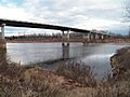
- White River: This river flows from northwest to southeast Arkansas, even briefly going into Missouri.
-
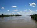
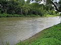
Arkansas River
at Little Rock -
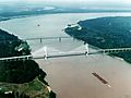
Mississippi River
at Lake Village -
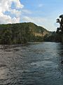
Ouachita River in the
Ouachita National Forest -
Red River
at Lewisville -
St. Francis River
at Parkin -
White River
at Buffalo City


Groundwater: Water Underground
Groundwater is water found beneath the Earth's surface in cracks and spaces in soil, sand, and rock. In Arkansas, groundwater provides over 60% of the water used. You can find good quality groundwater in shallow underground layers all over the state. In many mountain regions, surface water and groundwater are connected through karst topography, which means there are caves and sinkholes. Most groundwater monitoring areas in Arkansas have "generally good" water quality.
Protected Natural Areas in Arkansas

Arkansas has many special natural areas that are protected by different groups.
The Ozark Mountain forests are divided into the Ozark National Forest and the St. Francis National Forest. These are managed by the United States Forest Service. The Forest Service also takes care of other places like the Black Fork Mountain Wilderness and Blanchard Springs Caverns.
The National Park Service (NPS) manages Hot Springs National Park, which was actually the nation's very first national park! The park has old buildings from when it was a popular resort. Bathhouse Row used to be a busy street with fancy bathhouses, where people would use the spring water, believing it could cure many illnesses.
The NPS also looks after three National Historic Sites in Arkansas:
Pea Ridge National Military Park is the only National Military Park in the state, and Arkansas Post National Memorial is the only National Memorial.
The Arkansas Department of Parks and Tourism manages 52 state parks across Arkansas, as well as Poison Springs State Forest. These parks offer all kinds of activities, from hiking in large forests to water sports on lakes and rivers. Some parks are historical sites, and others are cemeteries that honor important Arkansans. Some of the most visited parks include Mount Magazine State Park, DeGray Lake Resort State Park, Crater of Diamonds State Park, Pinnacle Mountain State Park, Petit Jean State Park, Devil's Den State Park, Crowley's Ridge State Park, and Lake Ouachita State Park.
