
Table Rock Lake facts for kids
Table Rock Lake is a large, man-made lake, also called a reservoir, located in the beautiful The Ozarks region. You can find it in southwestern Missouri and northwestern Arkansas. This lake was created when the Table Rock Dam was built.
The dam is 252 feet (about 77 meters) tall. It was constructed between 1954 and 1958 on the White River by the United States Army Corps of Engineers. This group helps manage many of our nation's waterways.
Table Rock Lake is a very popular spot, especially for visitors to the nearby town of Branson, Missouri. Along the lake, you'll find many places where you can rent boats or launch your own. Table Rock State Park is also located right on the lake's eastern side.
Just below the dam, the Missouri Department of Conservation runs the Shepherd of the Hills Fish Hatchery. This hatchery raises trout to release into Lake Taneycomo. The water released from the dam is very cold, which is perfect for Rainbow trout and Brown trout to live and grow.

Lake Temperatures
The water temperature at Table Rock Lake changes with the seasons:
- Spring: 56 to 77 °F (25 °C)
- Summer: 85 to 90 °F (32 °C)
- Fall: 71 to 82 °F (28 °C)
- Winter: 42 to 47 °F (8 °C)
Dam and Lake Facts
Table Rock Dam is a very big structure. It is 6,423 feet (1,958 m) long in total. The deepest part of the lake is 220 feet (67 meters) deep. The lake has a huge shoreline, stretching for 745 miles (1,199 km) when the water is at its normal level.
Flood Control and Power
The main reason Table Rock Lake was built was to control floods on the White River. It also helps create hydroelectric power, which is electricity made from moving water. The lake is also a great place for fun activities in southern Missouri and northern Arkansas.
The dam was approved in 1941, but its construction was delayed by World War II and the Korean War. Work finally began in 1954.
Table Rock is the second of four major lakes on the White River before it flows into the Mississippi River. The other three lakes are Beaver Lake, Lake Taneycomo, and Bull Shoals Lake.
Fishing Fun
Table Rock Lake is famous for its Largemouth bass fishing. Many people consider it one of the best bass fishing lakes in the United States. You can find all three types of Black bass here: Largemouth, Smallmouth, and Spotted bass. The lake has even produced Largemouth bass weighing over 10 pounds and Smallmouth bass over 7 pounds!
Because of its great fishing, Table Rock Lake hosts several big bass fishing tournaments every year. Besides bass, you can also catch other game fish like Crappie, Walleye, White Bass, Paddlefish, Catfish, and Sunfish.
Just below Table Rock Dam, Lake Taneycomo is known as one of the top five fisheries in the world for Rainbow and Brown trout.
Images for kids
-
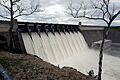
Table Rock Dam during the April 2008 flood with all flood gates open

