
Bull Shoals Lake facts for kids

Bull Shoals Lake is a large, man-made lake located in the beautiful Ozark Mountains. You can find it in northern Arkansas and southern Missouri. This huge lake was created by building a dam across the White River.
Bull Shoals Lake has many long arms and quiet coves. This makes it a perfect spot for fun activities like boating, water sports, swimming, and fishing. Around the lake, there are 19 parks. These parks offer places for camping, boat launches, swimming spots, and marinas where you can dock your boat.
Contents
Building the Bull Shoals Dam

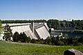
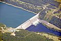
The Bull Shoals Dam was built to hold back the water of the White River. This created the large lake we see today. The dam is one of the biggest concrete dams in the United States. When the project began, it was the 5th largest dam in the whole world!
Work on the dam started in 1947 and finished in 1951. In 1952, Harry S. Truman, who was the President at the time, officially opened the dam. To make room for the new lake, many old family cemeteries and larger burial grounds had to be carefully moved.
How Bull Shoals Lake Works
Bull Shoals Lake is the last big lake on the White River before it flows into the mighty Mississippi River. There are three other lakes upstream from it: Beaver Lake, Table Rock Lake, and Lake Taneycomo.
The Army Corps of Engineers manages Bull Shoals Lake. Its main job is to control floods. This means the lake's water level changes often. The normal water level, called 'powerpool', is 654 feet above sea level. However, the water can go up to 680 feet or down to 630 feet.
The lake can cover 45,000 acres (about 182 square kilometers) with 700 miles (1,120 km) of shoreline at its normal level. During floods, it can grow to more than 70,000 acres (284 square kilometers) with 1,000 miles (1,600 km) of shoreline! The bottom of the lake is mostly solid rock with very few plants.
A special area called a 'buffer zone' protects the shoreline. This land is owned and managed by the Army Corps of Engineers. Because of this, there isn't much building right around Bull Shoals Lake. Most of its shoreline is covered in thick forests.
Bull Shoals-White River State Park

The Bull Shoals-White River State Park is a large park covering 725 acres (about 2.9 square kilometers). It is located in Baxter and Marion Counties in Arkansas. The park is found both above and below the huge dam.
The park offers many things to do along the banks of the White River. You can find camping spots, pavilions, docks for boats, and a nature center. There are 103 campsites right by the river and 20 spots for tents. You can also rent a camp or an RV site.
Picnic areas are spread throughout the park. There are also trails for hiking through the woods. A marina at the park has boating equipment and rents boats. The visitors' center offers fun programs, workshops, camps, and exhibits about boating and fishing. It even has an aquarium! You can also take tours of the power plant at the dam for a small fee.
Fishing at Bull Shoals Lake
Bull Shoals Lake is known as one of the best places for Largemouth bass fishing in the United States. The best time to catch bass is from March to May, when they come into the shallow waters to spawn.
As Arkansas's largest lake, Bull Shoals is also a popular spot for trout fishing. Huge Rainbow trout and brown trout have been caught here. Other fish like bream, catfish, crappie, and largemouth bass are also easy to find. Besides fishing, many people enjoy swimming and other water sports on the lake. Arkansas Highway 178 runs right over the top of Bull Shoals Dam and into the state park.
The 2008 Flood
In the spring of 2008, there was a lot of rainfall. This caused Bull Shoals Lake to reach its highest water level since 1957. The lake's water level went up to 695.02 feet above sea level. To prevent more flooding, the Army Corps of Engineers had to open the dam's floodgates.
Images for kids
-
Bull Shoals Dam
-
Aerial Photo of Bull Shoals Dam


