
Cache River (Arkansas) facts for kids
Quick facts for kids Cache River |
|
|---|---|

Cache River, Woodruff County
|
|

Map of the Cache River
|
|
| Country | United States |
| State | Arkansas |
| City | Clarendon |
| Physical characteristics | |
| Main source | Unnamed drainage ditches Butler County, Missouri 36°13′40″N 90°36′42″W / 36.22778°N 90.61167°W |
| River mouth | White River (Arkansas) Clarendon, Arkansas 151 ft (46 m) 34°42′7″N 91°19′30″W / 34.70194°N 91.32500°W |
| Length | 213 mi (343 km) |
| Basin features | |
| Tributaries |
|
| Protection status | |
| Official name: Cache-Lower White Rivers | |
| Designated: | 21 November 1989 |
| Reference #: | 442 |
The Cache River is a 213-mile (343 km) long river in northeastern Arkansas, United States. It is a tributary of the White River. The river's starting point, called its headwaters, is in southeastern Missouri.
The Cache River and the land around it are part of the larger Mississippi River watershed. This means all the water from this area eventually flows into the Mississippi River. The river flows through a region known as the Arkansas Delta.
Contents
Amazing Wildlife and Nature
The Cache River area is home to many different kinds of animals. It has 53 types of mammals, like bears. Over 200 kinds of birds live here or visit. You can also find nearly 50 types of reptiles and amphibians.
Home for Ducks
This area is super important for mallard ducks. It is the most important place for them and other migratory waterfowl to spend the winter in North America. Because of this, many people come here for duck hunting.
Black Bears and Rare Birds
The Cache River area is special because it has the only group of native American black bears left in Arkansas. It was also where some people thought they saw an ivory-billed woodpecker. This bird was believed to be extinct for 60 years!
Giant Forests
The land around the river has the biggest remaining area of bottomland hardwood forest in North America. These are forests that grow in low, wet areas. Because of all these unique features, the Cache River National Wildlife Refuge was created. This refuge protects about 90 miles (145 km) of the river's lower parts. This location was also used by Team Trees to plant some of their 20 million trees.
How the River Flows
The Cache River starts in Butler County, Missouri. It forms from several farm ditches joining together. Soon after, it flows into Arkansas. The river generally moves towards the south-southwest.
River Changes
Some parts of the river's upper section have been made straight and channelized. This means engineers changed the river's path to make it flow differently. The Cache River eventually joins the White River near the town of Clarendon, Arkansas.
River's Look
The Cache is a slow-moving, muddy river. It has many winding paths, sloughs (which are like muddy channels), swampy areas, and oxbow lakes. Oxbow lakes are U-shaped lakes that form when a river bend gets cut off from the main river.
A Bit of History
During the American Civil War, an important battle happened along the Cache River. This was the Battle of Cotton Plant, fought near the town of Cotton Plant, Arkansas.
What's in a Name?
The name "Cache" for the river likely comes from a French word. It might be from the Picardie language, meaning "hunt." This name probably refers to all the wildlife that lived along the river. The first European explorer to visit this area was Father Marquette. Picardie was his native language.
Gallery
-
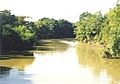
The Cache River near Cotton Plant, Arkansas
-
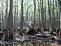
The Cache River in Woodruff County
-
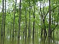
A flooded hardwood forest along the Cache River


.jpg)
