Clarendon, Arkansas facts for kids
Quick facts for kids
Clarendon, Arkansas
|
|
|---|---|
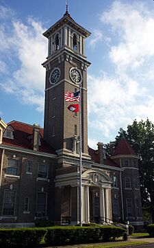
Monroe County Courthouse in downtown Clarendon
|
|
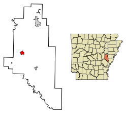
Location in Monroe County, Arkansas
|
|
| Country | United States |
| State | Arkansas |
| County | Monroe |
| Area | |
| • Total | 1.93 sq mi (5.00 km2) |
| • Land | 1.75 sq mi (4.53 km2) |
| • Water | 0.18 sq mi (0.46 km2) |
| Elevation | 174 ft (53 m) |
| Population
(2020)
|
|
| • Total | 1,526 |
| • Density | 872.50/sq mi (336.84/km2) |
| Time zone | UTC-6 (Central (CST)) |
| • Summer (DST) | UTC-5 (CDT) |
| ZIP code |
72029
|
| Area code(s) | 870 |
| FIPS code | 05-13990 |
| GNIS feature ID | 2404054 |
Clarendon is a city in Arkansas, United States. It is the main town, or county seat, of Monroe County. The city is located in a region called the Arkansas Delta. Its spot on the White River, where the Cache River joins it, has been important since it became a city in 1859.
Even though the river has sometimes caused floods and problems, it has also brought good things. It has helped with jobs, transportation, and fun activities like fishing and boating. Clarendon used to have many different businesses. Today, its economy mostly depends on farming. Like many towns in the Delta, Clarendon's population has become smaller. This is because new farm machines mean fewer people are needed for farm work. In 2020, about 1,526 people lived there.
Contents
Clarendon's Story: A Look Back
Early Days and Important Roads
The land around Clarendon was first home to different Native American groups. By 1799, French hunters and trappers had built small cabins here. This spot was important because it was where the Military Road crossed the White River. The Military Road was built between 1826 and 1828. It connected Memphis, Tennessee, to Little Rock.
By 1828, Clarendon had a ferry to cross the river and a post office. It was also the starting point for stagecoach trips going west. The Military Road was used during the Trail of Tears. This was when many Native American groups, like the Chickasaw, Choctaw, Creek, and Cherokee, were forced to move from their homes to Oklahoma.
Later, trains came to Clarendon. In 1872, the Arkansas Central Railway connected it to Helena, Arkansas. By 1883, the Texas and St. Louis Railway also reached Clarendon. This railway linked Texas and Missouri. These train lines later became part of bigger railway systems. They were called the St. Louis Southwestern Railway (Cotton Belt) and the St. Louis, Iron Mountain and Southern Railway.
Civil War and Rebuilding
Clarendon officially became a city in 1859. During the American Civil War, in 1864, the city was burned down. This happened after Confederate forces sank a Union gunboat called the USS Queen City. The Union Army burned Clarendon in return. The city's official status was stopped in 1884. But it became a city again in 1898.
Industries and a Big Flood
In the early 1900s, Clarendon had many businesses. People worked in lumber, making barrels, and crafting oars. They also made buttons from the shells of mussels found in the rivers. These mussels also produced freshwater pearls. Clarendon even had a market where these pearls were bought and sold. The Moss Brothers Bat Company in Clarendon made baseball bats for many famous players.
Like much of eastern Arkansas, Clarendon faced a huge disaster in 1927. This was the Great Mississippi Flood of 1927. The main wall, or levee, at Clarendon broke when the White River rose very high. The water flooded the town, reaching the second floors of many buildings. No one died, but the flood caused a lot of damage. It took many years to clean up all the mud and mess.
Modern Times and Nature's Return
Today, the area around Clarendon is mostly used for farming. People also visit for hunting and fishing. These activities help the local economy. In 2004–2005, there was exciting news. People thought they had seen the ivory-billed woodpecker again. This rare bird was spotted in the Cache River and White River National Wildlife Refuges. This brought new attention to the area.
Clarendon's Location and Weather
Where is Clarendon?
Clarendon is about 16 miles southwest of Brinkley. It is also 21 miles northeast of Stuttgart. And it's about 33 miles west-southwest of Marianna.
The city covers about 1.93 square miles. Most of this is land, and a small part is water. Clarendon is right where the Cache River flows into the White River.
What is Clarendon's Climate Like?
Clarendon has a humid subtropical climate. This means it has hot, humid summers. The winters are usually mild to cool.
| Climate data for Clarendon, Arkansas | |||||||||||||
|---|---|---|---|---|---|---|---|---|---|---|---|---|---|
| Month | Jan | Feb | Mar | Apr | May | Jun | Jul | Aug | Sep | Oct | Nov | Dec | Year |
| Record high °F (°C) | 79 (26) |
85 (29) |
86 (30) |
93 (34) |
95 (35) |
102 (39) |
106 (41) |
104 (40) |
101 (38) |
94 (34) |
85 (29) |
79 (26) |
106 (41) |
| Mean daily maximum °F (°C) | 49 (9) |
54 (12) |
63 (17) |
72 (22) |
81 (27) |
88 (31) |
91 (33) |
91 (33) |
84 (29) |
74 (23) |
62 (17) |
51 (11) |
72 (22) |
| Mean daily minimum °F (°C) | 30 (−1) |
34 (1) |
42 (6) |
50 (10) |
60 (16) |
68 (20) |
72 (22) |
69 (21) |
60 (16) |
49 (9) |
41 (5) |
33 (1) |
51 (11) |
| Record low °F (°C) | −4 (−20) |
3 (−16) |
15 (−9) |
28 (−2) |
35 (2) |
48 (9) |
53 (12) |
49 (9) |
36 (2) |
28 (−2) |
16 (−9) |
−2 (−19) |
−4 (−20) |
| Average precipitation inches (mm) | 3.69 (94) |
4.40 (112) |
4.90 (124) |
5.17 (131) |
5.35 (136) |
3.83 (97) |
3.86 (98) |
2.27 (58) |
3.30 (84) |
4.45 (113) |
4.98 (126) |
5.51 (140) |
51.71 (1,313) |
| Average snowfall inches (cm) | 0.7 (1.8) |
0.2 (0.51) |
0 (0) |
0 (0) |
0 (0) |
0 (0) |
0 (0) |
0 (0) |
0 (0) |
0 (0) |
0 (0) |
0 (0) |
0.9 (2.3) |
| Average precipitation days (≥ 0.01 in) | 9.0 | 9.2 | 9.9 | 8.7 | 10.4 | 7.8 | 7.3 | 5.8 | 6.0 | 7.5 | 8.9 | 9.0 | 99.5 |
| Average snowy days (≥ 0.1 in) | 0.1 | 0 | 0 | 0 | 0 | 0 | 0 | 0 | 0 | 0 | 0 | 0 | 0.1 |
| Source: The Weather Channel | |||||||||||||
Who Lives in Clarendon?
| Historical population | |||
|---|---|---|---|
| Census | Pop. | %± | |
| 1880 | 400 | — | |
| 1890 | 1,060 | 165.0% | |
| 1900 | 1,840 | 73.6% | |
| 1910 | 2,037 | 10.7% | |
| 1920 | 2,638 | 29.5% | |
| 1930 | 2,149 | −18.5% | |
| 1940 | 2,551 | 18.7% | |
| 1950 | 2,547 | −0.2% | |
| 1960 | 2,293 | −10.0% | |
| 1970 | 2,563 | 11.8% | |
| 1980 | 2,361 | −7.9% | |
| 1990 | 2,072 | −12.2% | |
| 2000 | 1,960 | −5.4% | |
| 2010 | 1,664 | −15.1% | |
| 2020 | 1,526 | −8.3% | |
| U.S. Decennial Census | |||
Population in 2020
In 2020, the city had 1,526 people. There were 741 households and 397 families living in Clarendon.
| Group | Number | Percentage |
|---|---|---|
| White | 859 | 56.29% |
| Black or African American | 541 | 35.45% |
| Native American | 14 | 0.92% |
| Asian | 4 | 0.26% |
| Pacific Islander | 2 | 0.13% |
| Other/Mixed | 45 | 2.95% |
| Hispanic or Latino | 61 | 4.0% |
Clarendon's Economy
Clarendon's economy is mostly based on farming. The city government and the Clarendon School District are also important employers. They provide many jobs for people in the city.
Schools in Clarendon
Students in Clarendon attend public schools run by the Clarendon School District. The schools include:
- Clarendon Elementary School, for students from pre-kindergarten to 6th grade.
- Clarendon High School, for students in grades 7 through 12.
City Services and Transportation
Healthcare Services
The Mid-Delta Health Center in Clarendon offers medical and dental care. It serves people in Clarendon and nearby areas. In 2013, over 3,300 patients used this clinic.
Getting Around Clarendon
The main road through Clarendon is U.S. Highway 79. This highway connects Clarendon to Stuttgart to the south. It also goes to Marianna to the east. You can reach Brinkley to the north by taking U.S. Highway 49.
A special road, U.S. Highway 79B, goes through the center of Clarendon. Highway 302 is another road that starts in Clarendon and goes north.
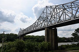
The old Clarendon Bridge over the White River was very old. A new bridge has been built south of Clarendon. This new bridge helps traffic flow better. The old 1931 bridge was important for history. People wanted to save it for walking and biking. However, the main part of the old bridge was taken down in November 2019.
City Utilities
Clarendon has a system to collect and clean wastewater. The Clarendon Wastewater Treatment Plant is south of town. It uses special methods to clean the water. This makes sure the water is safe before it goes back into nature.
See also
 In Spanish: Clarendon (Arkansas) para niños
 | William Lucy |
 | Charles Hayes |
 | Cleveland Robinson |


