Devil's Den State Park facts for kids
Quick facts for kids Devil's Den State Park |
|
|---|---|
|
IUCN Category III (Natural Monument)
|
|

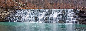
Waterfall in Devil's Den State Park
|
|
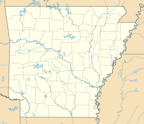
| Location | Washington County, Arkansas, United States |
| Area | 2,500 acres (10 km2) |
| Elevation | 1,020 ft (310 m) |
| Established | 1933 |
| Named for | Devil's Den cave |
| Governing body | Arkansas Department of Parks and Tourism |
| Website | Devils Den State Park |
Devil's Den State Park is a beautiful state park in Washington County, Arkansas. It covers about 2,500-acre (1,000 ha) of land. The park is located near West Fork, Arkansas in the United States.
Construction on the park began in 1933. It was built by young men from the Civilian Conservation Corps (CCC). Devil's Den State Park is nestled in the Lee Creek Valley. This valley is part of the Boston Mountains, which are in the southwestern The Ozarks.
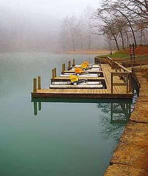
The park has an 8 acres (3.2 ha) lake, also built by the CCC. It's open all year for fun activities. You can find trails for hiking, mountain biking, and even horseback riding. The park also offers picnic spots, a swimming pool, cabins, and many camping sites. You can find coral and crinoid fossils along Lee Creek.
Contents
History of Devil's Den State Park
Devil's Den State Park is special because it protects the largest sandstone crevice area in the United States. The Lee Creek Valley has many sandstone caves, bluffs, and hidden spots. These places were once used as hiding spots.
Early Use of the Valley
From 1858 until the American Civil War began in 1861, outlaws used these hidden spots. They hid from the law along the Butterfield Stage Line. During the Civil War, the rocky area became a hideout for Confederate guerrilla groups. They used it to plan raids on the Union Army's supply lines. Both Confederate and Union soldiers used the Butterfield Stage Line roads during the war. They used them for battles like the Battle of Prairie Grove and the Raid on Van Buren.
The old town of Anna was once inside the park. A big flood destroyed it in 1893. Today, you can still see a cemetery, a well, and some old building foundations. These remnants of Anna are along the Butterfield Hiking Trail.
Building the Park with the CCC
During the Great Depression, the Lee Creek Valley was chosen for a state park. Work started in 1933. Young men from the Civil Civilian Conservation Corps (CCC) built Devil's Den State Park. The CCC was a program started by President Franklin D. Roosevelt. It gave jobs to unemployed men across the United States.
The CCC workers lived in military-style barracks. They built many parts of the park we see today. This includes picnic areas, trails, and the dam on Lee Creek. This dam created Lake Devil. In the 1970s, the park was updated, and the CCC-built structures were fixed up. Devil's Den State Park is known as one of the best-preserved CCC projects in the United States. It was added to the National Register of Historic Places in 1994. This was because of its unique "Rustic architecture" style.
Geology of the Park
Devil's Den State Park is located in the Lee Creek Valley. This valley is part of the Boston Mountains, which are in The Ozarks. This area is a high, rocky plateau in northern Arkansas and eastern Oklahoma.
Rock Formations
The rocks here are mostly flat layers of sedimentary rock. These layers formed a very long time ago during the Paleozoic Era. The highest parts of the mountains are topped with Pennsylvanian sandstone and shale. The deep valleys are cut into Mississippian limestone. Below that, you can find Ordovician dolomite.
The caves, ravines, and crevices in the park formed partly from sandstone layers slipping. The Devil's Ice Box is a popular cave. It's named for the cool air that blows out of it. Air enters the cave higher up the mountain. It cools down as it travels through the mountain before coming out of the cave's mouth.
Fun Things to Do
Devil's Den State Park offers many ways to enjoy nature.
Cabins and Camping
The park has 17 cabins available for rent. These cabins are along Lee Creek. They have a "rustic" look but come with fully equipped kitchens. They also have heating and air-conditioning. The cabins have stone fireplaces and are open all year.
There are also 146 campsites. Some have electricity and running water. Others are simple, cleared spots for setting up a tent.
Trails for Adventure
Devil's Den State Park has about 64 miles (103 km) of trails. You can hike, mountain bike, or ride horses on these trails. About 20 miles (32 km) of the trails are just for horses. All horse trails start and end at the park's horse camp. Some trails even go into the nearby Ozark National Forest.
- Old Road Trail: This trail is 4.5 miles (7.2 km) long. It's named after the old dirt road, Arkansas Highway 170, built by the CCC. It's the only trail completely inside the park. You can see old car parts from long ago near the start. The trail goes through a cedar grove and past the Yellow Rock Bluff overlook. Horses must be tied up before you walk to the overlook. It also passes by the CCC overlook.
- Gorley King Trail: This trail is 7 miles (11 km) long. It's named after Gorley King, who rode these trails for many years. He helped create and maintain many trails in the area. The trail starts at the horse camp and goes down Lee Creek Valley. It joins the Butterfield Hiking Trail and Vista Point Trail. It climbs the valley and goes into Ozark National Forest.
- Vista Point Trail: This trail is 9 miles (14 km) long. It follows the Gorley King Trail for 1.5 miles (2.4 km). Then it goes up Holt Ridge and onto a plateau in Ozark National Forest. You'll pass an old quarry used by the CCC. It also goes over Mount Olive and crosses the Butterfield Hiking Trail. The trail loops back towards the park, passing an old 19th-century home and the Vista Point Overlook.
- Butterfield Hiking Trail: This loop trail is 15 miles (24 km) long and marked with blue signs. It starts and ends in Devil's Den State Park. It goes through Ozark National Forest in Washington and Crawford County. The trail is named after the Butterfield Stage Line. This was a stagecoach route that carried mail across the United States from 1857 to 1861. A writer once said the road through the Boston Mountains was "steep, rugged, jagged, rough and mountainous."
- CCC Interpretive Trail: This short trail is only 0.25 miles (0.40 km) long. It's a self-guided trail that goes through the old Civilian Conservation Corps camp. Signs along the trail explain the history of the CCC at Devil's Den State Park.
- Cross Country Mountain Bike Trail: This trail is 15 miles (24 km) long. It has creek crossings, dirt roads, and long uphills and downhills. It's split into three loops and goes outside the park into Ozark National Forest. Riders need a permit from the park office to use this trail.
- Devil's Den Self-Guided Trail: This is a National Recreation Trail. It is 1.5 miles (2.4 km) long. It takes you past two popular spots: Devil's Den and the Devil's Icebox. You'll also see interesting rock formations, waterfalls after rain, and lots of plants and animals.
- Yellow Rock Trail: This trail is 3 miles (4.8 km) long. You'll climb 300 feet (91 m) to reach one of the best views in the park. From Yellow Rock, you get a clear view of the Lee Creek valley. Along the trail, you'll see cedar trees, cool rock formations, and the first building ever built in the park.
- Fossil Flats: This trail is 3 miles (4.8 km) to 5 miles (8.0 km) long. You can mountain bike or hike it. The name comes from the flat, exposed rock in the creek bed. You can see many fossils in the creek bed here. Along the trail, you'll find signs of the CCC and early settlers, creek views, and large rock formations. This trail lets riders choose different lengths, and the difficulty increases with each mile.
Protecting the Bats: Cave Closures
Since April 16, 2010, the park's caves have been temporarily closed to visitors. This is to help stop the spread of a serious fungal infection called White Nose Syndrome. This disease affects bats.
The fungus, called Geomyces destructans, harms bats. It affects several types of bats found in Arkansas, including the Ozark big-eared bat, Indiana bat, and gray myotis. These three bats are endangered. Other bats like the brown bat and tri-colored bat are also affected. Closing the caves helps protect these important animals.
 | Jackie Robinson |
 | Jack Johnson |
 | Althea Gibson |
 | Arthur Ashe |
 | Muhammad Ali |


