Crawford County, Arkansas facts for kids
Quick facts for kids
Crawford County
|
|
|---|---|

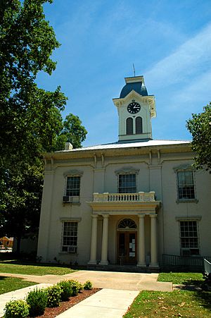
Crawford County Courthouse within the Van Buren Historic District
|
|

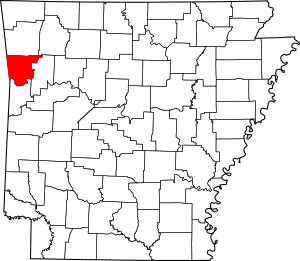
Location within the U.S. state of Arkansas
|
|
 Arkansas's location within the U.S. |
|
| Country | |
| State | |
| Named for | William H. Crawford |
| Seat | Van Buren |
| Largest city | Van Buren |
| Area | |
| • Total | 604 sq mi (1,560 km2) |
| • Land | 593 sq mi (1,540 km2) |
| • Water | 11 sq mi (30 km2) 1.8%% |
| Population
(2020)
|
|
| • Total | 60,133 |
| • Density | 99.56/sq mi (38.44/km2) |
| Time zone | UTC−6 (Central) |
| • Summer (DST) | UTC−5 (CDT) |
| Congressional district | 3rd |
Crawford County is a county in the Ozarks region of Arkansas. In 2020, about 60,133 people lived here. The main city and county seat is Van Buren.
Crawford County was created on October 18, 1820. It was named after William H. Crawford. He was the United States Secretary of War in 1815.
Most of the county is in the Ozarks. The Arkansas River forms its southern border. This area was an important crossroads long ago. People traveled through it during the California Gold Rush. Later, the Butterfield Overland Mail route passed through. Civil War trails and railroads also used this path. Today, two big highways, Interstate 40 and Interstate 49, meet here. Crawford County is part of the Fort Smith metropolitan area.
Contents
Exploring Crawford County's Landscape
Crawford County is in the northwest part of Arkansas. The U.S. Census Bureau says the county covers about 604 square miles. Most of this area, 593 square miles, is land. The rest, about 11 square miles, is water.
Main Roads and Travel Routes
Many important roads cross Crawford County. These highways help people travel and transport goods.
 Interstate 40
 Interstate 49
 US 64
US 64 US 71
US 71 Highway 59
 Highway 60
 Highway 162
 Highway 282
 Highway 348
There are plans to extend I-49 through Arkansas. This new highway will connect New Orleans, Louisiana, to Kansas City, Missouri. This route is important for trucks. Part of I-49 already goes north from Van Buren. It passes through Benton County, where Walmart started.
Public Transportation
- Jefferson Lines provides bus service in the area.
Neighboring Counties
Crawford County shares borders with several other counties:
- Washington County (north)
- Madison County (northeast)
- Franklin County (east)
- Sebastian County (south)
- Le Flore County, Oklahoma (southwest)
- Sequoyah County, Oklahoma (west)
- Adair County, Oklahoma (northwest)
Protected Natural Areas
Part of the Ozark National Forest is located in Crawford County. This is a protected area.
Understanding Crawford County's Population
| Historical population | |||
|---|---|---|---|
| Census | Pop. | %± | |
| 1830 | 2,440 | — | |
| 1840 | 4,266 | 74.8% | |
| 1850 | 7,960 | 86.6% | |
| 1860 | 7,850 | −1.4% | |
| 1870 | 8,957 | 14.1% | |
| 1880 | 14,740 | 64.6% | |
| 1890 | 21,714 | 47.3% | |
| 1900 | 21,270 | −2.0% | |
| 1910 | 23,942 | 12.6% | |
| 1920 | 25,739 | 7.5% | |
| 1930 | 22,549 | −12.4% | |
| 1940 | 23,920 | 6.1% | |
| 1950 | 22,727 | −5.0% | |
| 1960 | 21,318 | −6.2% | |
| 1970 | 25,677 | 20.4% | |
| 1980 | 36,892 | 43.7% | |
| 1990 | 42,493 | 15.2% | |
| 2000 | 53,247 | 25.3% | |
| 2010 | 61,948 | 16.3% | |
| 2020 | 60,133 | −2.9% | |
| 2023 (est.) | 61,891 | −0.1% | |
| U.S. Decennial Census 1790–1960 1900–1990 1990–2000 2010 |
|||
Population in 2020
In 2020, the 2020 United States census counted 60,133 people in Crawford County. There were 23,958 households. About 17,082 families lived in the county.
Here's a look at the different groups of people living in Crawford County in 2020:
| Group | Number | Percentage |
|---|---|---|
| White (not Hispanic) | 47,627 | 79.2% |
| Black or African American (not Hispanic) | 857 | 1.43% |
| Native American | 1,366 | 2.27% |
| Asian | 939 | 1.56% |
| Pacific Islander | 27 | 0.04% |
| Other/Mixed | 4,750 | 7.9% |
| Hispanic or Latino | 4,567 | 7.59% |
Towns and Cities in Crawford County
Crawford County has several cities and towns. These are places where people live and work.
Cities
- Alma
- Cedarville
- Dyer
- Kibler
- Mountainburg
- Mulberry
- Van Buren (This is the county seat, meaning it's the main city for county government.)
Towns
Unincorporated Communities
These are smaller places that are not officially cities or towns.
Townships
Townships in Arkansas are the divisions of a county. Each township includes unincorporated areas; some may have incorporated cities or towns within part of their boundaries. Arkansas townships have limited purposes in modern times. However, the United States Census does list Arkansas population based on townships (sometimes referred to as "county subdivisions" or "minor civil divisions"). Townships are also of value for historical purposes in terms of genealogical research. Each town or city is within one or more townships in an Arkansas county based on census maps and publications. The townships of Crawford County are listed below; listed in parentheses are the cities, towns, and/or census-designated places that are fully or partially inside the township.
- Alma
- Bidville
- Cedar Creek
- Cedarville
- Chester
- Cove City
- Dean Springs
- Dora
- Dyer
- Jasper
- Kibler
- Lancaster
- Lees Creek
- Locke
- Mountainburg
- Mulberry
- Oliver Springs
- Porter
- Rudy
- Uniontown
- Upper
- Van Buren
- Vine Prairie
- Whitley
- Winfrey
See also
 In Spanish: Condado de Crawford (Arkansas) para niños
 | George Robert Carruthers |
 | Patricia Bath |
 | Jan Ernst Matzeliger |
 | Alexander Miles |

