Uniontown, Arkansas facts for kids
Quick facts for kids
Uniontown, Arkansas
|
|
|---|---|

Slack-Comstock-Marshall Farm
|
|
| Country | United States |
| State | Arkansas |
| County | Crawford |
| Elevation | 866 ft (264 m) |
| Population
(2020)
|
|
| • Total | 112 |
| Time zone | UTC-6 (Central (CST)) |
| • Summer (DST) | UTC-5 (CDT) |
| ZIP code |
72955
|
| Area code(s) | 479 |
| GNIS feature ID | 2805689 |
Uniontown is a small community in Crawford County, Arkansas, United States. It is known as an "unincorporated community." This means it does not have its own local government like a city or town. However, it is also a "census-designated place" (CDP). This means the U.S. Census Bureau counts its population separately for official records.
Uniontown is located on Arkansas Highway 220. It is very close to the Oklahoma border. The community is about 4.5 miles (7.2 km) west-northwest of Cedarville. Uniontown has its own post office with the ZIP code 72955. In the 2020 census, Uniontown had a population of 112 people.
History
The first people to settle permanently in Uniontown were the Howell family. They arrived in the 1840s. A post office has been open in Uniontown since 1881.
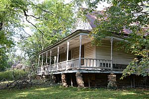
A special place called Slack-Comstock-Marshall Farm is located in the community. This farm is listed on the National Register of Historic Places. This means it is an important historical site in the United States.
Population
| Historical population | |||
|---|---|---|---|
| Census | Pop. | %± | |
| 2020 | 112 | — | |
| U.S. Decennial Census 2020 |
|||
Uniontown was first counted as a census-designated place in 2020. At that time, its population was 112 people.
 | Toni Morrison |
 | Barack Obama |
 | Martin Luther King Jr. |
 | Ralph Bunche |


