
U.S. Route 64 in Arkansas facts for kids
Quick facts for kids
|
||||
|---|---|---|---|---|
_map.svg) |
||||
| Route information | ||||
| Maintained by AHTD | ||||
| Length | 246.35 mi (396.46 km) | |||
| Existed | 1926–present | |||
| Major junctions | ||||
| West end | ||||
| East end | ||||
| Location | ||||
| Counties: | Sebastian, Crawford, Franklin, Johnson, Pope, Conway, Faulkner, White, Woodruff, Cross, Crittenden | |||
| Highway system | ||||
| United States Numbered Highways List • Bannered • Divided • Replaced Arkansas Highway System
|
||||

U.S. Route 64 (often called US 64) is a major highway that crosses the United States. It starts in Teec Nos Pos, Arizona and goes all the way east to Nags Head, North Carolina. In the state of Arkansas, this road stretches for about 246 miles (396 km). It begins at the Oklahoma border near Fort Smith and ends at the Tennessee border in Memphis.
Along its path, US 64 connects many important cities and towns. These include Fort Smith, Clarksville, Russellville, Conway, Searcy, and West Memphis. For a good part of its journey, US 64 runs right next to Interstate 40 (I-40). However, near Conway, I-40 turns south, and US 64 continues on its own path.
Exploring U.S. Route 64 in Arkansas


When US 64 enters Arkansas from Oklahoma, it crosses the Arkansas River and heads into downtown Fort Smith. Right away, you'll see historic spots like the Fort Smith National Historic Site and the Commercial Hotel. These places are listed on the National Register of Historic Places because they are very important to history.
In Fort Smith, US 64 uses different streets for traffic going in different directions. Westbound cars use 10th Street, and eastbound cars use 11th Street. The highway then crosses the Arkansas River again as it enters Van Buren. In Van Buren, US 64 passes the Van Buren Post Office before turning east. It then becomes the Alma Highway and crosses I-540 before reaching Alma.
For a long stretch, US 64 stays close to Interstate 40. It also follows the Arkansas River, the Union Pacific Railroad, and the southern edge of the Ozark National Forest.
Journey Through the Ozarks
As US 64 continues east, it goes through the mountains of Franklin County. In Ozark, it crosses the beautiful Pig Trail Scenic Byway. You can also see the Franklin County Courthouse and the Ozark Courthouse Square Historic District here.
The route then passes through Wiederkehr Village and enters Johnson County. It goes through small towns like Coal Hill and Hartman. After curving northeast, it crosses over I-40 again.
Next, US 64 reaches Clarksville, which is home to the University of the Ozarks. In Clarksville, you'll find the Johnson County Courthouse and the Clarksville Municipal Airport. The highway also passes near Lake Dardanelle before crossing I-40 one more time and entering Pope County.
Traveling Eastward
In Pope County, US 64 continues to run alongside Interstate 40. It passes through cities like Russellville and Morrilton.
When it reaches Faulkner County, US 64 briefly joins with U.S. Route 65B in Conway. It then turns east onto Oak Street, moving away from US 65 Business and I-40.
The highway then goes towards Vilonia. A new bypass was built around Vilonia in 2011, so US 64 no longer goes through the city's Main Street. It rejoins its old path west of the White County line and continues to El Paso.
From El Paso, US 64 travels east to Beebe. Here, it used to go through Center Street and join US 67 and US 167. Now, these three US highways all run together on a divided highway northwest of Beebe. The old route through Center Street is now called U.S. Route 67B.
Through Searcy and Beyond
US 64 continues on this divided highway, passing McRae, Garner, and Searcy. In Searcy, its original path went north on Main Street and then east on Race Avenue. This old route is now signed as U.S Route 67B. Later, US 64, 67, and 167 were moved southeast of Searcy along Eastline Road, which is now Arkansas Highway 367. Today, all three highways keep going northeast on a divided highway next to Eastline Road.

US 64 separates from US 67 and 167 on the northeast side of Bald Knob. Its old route went downtown along Highway Avenue, which is now Arkansas Highway 367. US 64 turns east towards the White River and Woodruff County.
US 64 keeps going east through Augusta and McCrory. It crosses US Route 49 at Fair Oaks and goes around Wynne in Cross County. Then it enters Crittenden County, passing through Earle and Crawfordsville. Finally, it joins Interstate 55 at Marion.

Its old route used to continue east along Military Road, then turn south onto the Great River Road. It would then meet US Route 63, which has also been moved to Interstate 55. This old route is now called Arkansas Highway 77.
US 64 continues south to West Memphis. Its current path turns east north of West Memphis, where Interstates 55 and 40 briefly join. Then, US 64 enters Tennessee and downtown Memphis by crossing the Mississippi River on the Interstate 55 bridge.
The Great US 64 Yard Sale
Every August, a huge yard sale takes place along about 160 miles (257 km) of US 64 in Arkansas. It's similar to the famous 127 Corridor Sale. This event stretches from Fort Smith all the way to Beebe, bringing lots of people together!
A Look Back: History of US 64
The Arkansas River Valley has always been an important path for travelers moving east and west across Arkansas. For centuries, people used this flat area between the Ozark Mountains and the Ouachita Mountains. When the United States Army started building the Memphis to Little Rock Road in 1824, they followed an old trail that was already there.
Historic Road Sections
Some original parts of US 64 are still around today and are listed on the National Register of Historic Places. These sections help us remember how roads were built long ago. For example, parts of the road in Menifee, Scotia, Van Buren, and Altus are protected. The Horsehead Creek Bridge near Hartman is also a historic spot.
These old road sections are part of a special project called the Arkansas Highway History and Architecture Multiple Property Submission. This project helps save the history of Arkansas's road building from 1910 to 1965. The Horsehead Creek Bridge is part of another project called Historic Bridges of Arkansas MPS. Sadly, two other historic bridges that were listed were taken down: the 1920 Galla Creek Bridge in 2000 and the 1930 Augusta Bridge in 2002.
Van Buren's Old Road
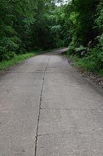
The Old US 64-Van Buren Segment is a piece of historic road in Van Buren. It's now called Oak Lane. This concrete road was built in 1928 and was part of the first US 64 route. The current US 64 route was built in 1968 and goes south of this old section. This old road is about 0.65 miles (1.05 km) long and 18 feet (5.5 m) wide. It was the first concrete-paved road in Crawford County.
Altus's Stone Pavement
The Johnson County Line-Ozark-Crawford County Line Road, Altus Segment is a historic road section in Altus. It's a 425-foot (130 m) long section of road paved with stone. You can find it north of the current US 64. This part of the road is about 10 feet (3.0 m) wide and has gravel shoulders. It also has a small concrete bridge. Built between 1918 and 1931, it's the only known example of stone pavement in a rural area of Arkansas. In 1931, US 64 was moved to a new path, and this section became a small connector road.
Horsehead Creek Bridge
The US 64 Horsehead Creek Bridge is a historic bridge that carries US 64 over Horsehead Creek east of Hartman. It has two main sections called Parker pony trusses, each 102 feet (31 m) long. With its steel approach spans, the bridge is 415 feet (126 m) long in total. It was built between 1933 and 1934 by Fred Luttjohann. This bridge was a very important crossing point until Interstate 40 was built further north.
Scotia's Historic Path
The Old US 64, Scotia Segment is a historic road section in the small community of Scotia. It starts east of Country Lane, south of the current US 64. It's about 0.5 miles (0.80 km) long and follows a curved path. The road is covered in a material that has worn down to gravel in some places. This is believed to be the longest surviving part of the US 64 route from around 1920 in Arkansas. It was built on a path that dates back to the 1830s. Many believe this road was part of the Trail of Tears, a sad time in history when Native Americans were forced to move from their homes.
Menifee's Old Alignment
Old U.S. Route 64 in Menifee is a historic former section of US 64. Now part of Canal Road, it's a 0.5-mile (0.80 km) section of concrete pavement. It goes south from the current US 64 near the center of Menifee. This part of the road was built in 1931 and is the longest intact section of the highway's original path in Conway County. The current road bypassed this section in 1961.
Historic Segment Gallery
-
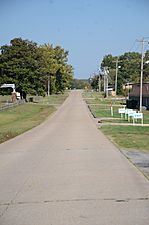
Van Buren segment looking east
-
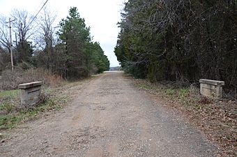
Altus segment
-
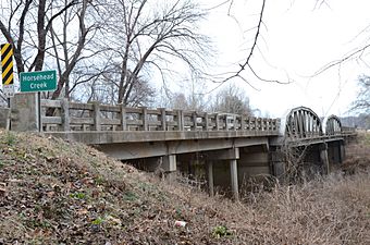
Horsehead Creek Bridge
-
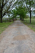
Scotia segment
-
Menifee segment


