
White County, Arkansas facts for kids
Quick facts for kids
White County
|
|||
|---|---|---|---|

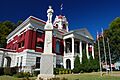
White County Courthouse and Confederate monument in Searcy
|
|||
|
|||

Location within the U.S. state of Arkansas
|
|||
 Arkansas's location within the U.S. |
|||
| Country | |||
| State | |||
| Founded | October 23, 1835 | ||
| Named for | Hugh Lawson White | ||
| Seat | Searcy | ||
| Largest city | Searcy | ||
| Area | |||
| • Total | 1,042 sq mi (2,700 km2) | ||
| • Land | 1,035 sq mi (2,680 km2) | ||
| • Water | 7.1 sq mi (18 km2) 0.7%% | ||
| Population
(2020)
|
|||
| • Total | 76,822 | ||
| • Estimate
(2023)
|
78,452 |
||
| • Density | 73.73/sq mi (28.466/km2) | ||
| Time zone | UTC−6 (Central) | ||
| • Summer (DST) | UTC−5 (CDT) | ||
| Congressional district | 2nd | ||


White County is a county located in the state of Arkansas in the United States. In 2020, about 76,822 people lived there. The main town and county seat is Searcy.
White County became Arkansas's 31st county on October 23, 1835. It was created from parts of Independence, Jackson, and Pulaski counties. The county was named after Hugh Lawson White, who was a candidate for President of the United States. White County is known as a "dry county," which means that selling alcohol is generally not allowed, though some private places can serve it.
Contents
History of White County
The first American settlers believed to have arrived in White County were John and Nancy Magness. They came from Tennessee around 1815 and started a farm near what is now Letona. The county was officially formed by the Arkansas territorial legislature on October 23, 1835.
During the American Civil War, White County saw some action. On May 17, 1862, a small fight called the Little Red Skirmish happened between Union and Confederate forces. This was followed by the Battle at Whitney Lane in June, also known as The Skirmish at Searcy Landing.
In the 1960s, the U.S. Department of Defense built several large missile silos for Titan II missiles in the county. Sadly, an accident happened at one of these sites in 1965, which resulted in the loss of workers' lives.
Geography and Nature
White County covers a total area of about 1,042 square miles. Most of this area, about 1,035 square miles, is land, and a small part, about 7.1 square miles, is water. It is the second-largest county in Arkansas by land area.
Main Roads
Many important roads run through White County, connecting different towns and areas. These include:
 Future Interstate 57
 U.S. Highway 64
 U.S. Highway 67
 U.S. Highway 167
 Highway 5
 Highway 11
 Highway 13
 Highway 16
 Highway 31
 Highway 36
 Highway 87
 Highway 110
 Highway 124
 Highway 157
 Highway 258
 Highway 267
 Highway 305
 Highway 310
 Highway 320
 Highway 321
 Highway 323
 Highway 367
 Highway 385
Neighboring Counties
White County shares borders with several other counties:
- Independence County (to the north)
- Jackson County (to the northeast)
- Woodruff County (to the east)
- Prairie County (to the southeast)
- Lonoke County (to the southwest)
- Faulkner County (to the west)
- Cleburne County (to the northwest)
Protected Natural Areas
White County is home to important natural areas, including:
- Bald Knob National Wildlife Refuge
- Henry Gray / Hurricane Lake Wildlife Management Area
People of White County
| Historical population | |||
|---|---|---|---|
| Census | Pop. | %± | |
| 1840 | 929 | — | |
| 1850 | 2,619 | 181.9% | |
| 1860 | 8,316 | 217.5% | |
| 1870 | 10,347 | 24.4% | |
| 1880 | 17,794 | 72.0% | |
| 1890 | 22,946 | 29.0% | |
| 1900 | 24,864 | 8.4% | |
| 1910 | 28,574 | 14.9% | |
| 1920 | 34,603 | 21.1% | |
| 1930 | 38,269 | 10.6% | |
| 1940 | 37,176 | −2.9% | |
| 1950 | 38,040 | 2.3% | |
| 1960 | 32,745 | −13.9% | |
| 1970 | 39,253 | 19.9% | |
| 1980 | 50,835 | 29.5% | |
| 1990 | 54,676 | 7.6% | |
| 2000 | 67,165 | 22.8% | |
| 2010 | 77,076 | 14.8% | |
| 2020 | 76,822 | −0.3% | |
| 2023 (est.) | 78,452 | 1.8% | |
| U.S. Decennial Census 1790–1960 1900–1990 1990–2000 2010 |
|||

In 2020, the census counted 76,822 people living in White County. There were 28,621 households and 18,028 families.
Population Makeup in 2020
| Group | Number of People | Percentage |
|---|---|---|
| White (not Hispanic) | 64,363 | 83.78% |
| Black or African American (not Hispanic) | 3,677 | 4.79% |
| Native American | 319 | 0.42% |
| Asian | 616 | 0.8% |
| Pacific Islander | 25 | 0.03% |
| Other/Mixed | 4,323 | 5.63% |
| Hispanic or Latino | 3,499 | 4.55% |
Economy
White County has a strong economy with some notable businesses. One of Arkansas's largest banks, First Security Bank, started in Searcy in 1932. Today, it has many locations and billions of dollars in assets.
The first Wal-Mart distribution center built outside of its main headquarters in Bentonville was also located in Searcy.
Education
White County offers many educational opportunities, from public schools to colleges.
Public Schools
Several public school districts serve the students of White County:
|
|
Private Schools
There are also several private schools in White County:
|
|
Colleges and Universities
For higher education, students can attend:
- Arkansas State University-Beebe: A public college established in 1927.
- Arkansas State University-Searcy: A technical branch of Arkansas State University.
- Harding University: A private university affiliated with Churches of Christ, with over 6,000 students.
Communities
White County has many towns and communities where people live.
Cities
Towns
Unincorporated Communities
These are smaller communities that are not officially cities or towns:
- Albion
- Antioch
- Andrews
- Bare Stone
- Barrentine Corner
- Bee Rock
- Belcher
- Center Hill
- Clay
- Conant
- Crosby
- Dewey
- Dogwood
- Doniphan
- El Paso
- Enright
- Essex
- Floyd
- Four Mile Hill or "Boot Hill"
- Georgia Ridge
- Gravel Hill
- Hammondsville
- Happy
- Harmony
- Hart
- Hickory Flat
- Holly Springs
- Joy
- Keeler Corner
- Liberty Valley
- Little Red
- Midway (near Bald Knob)
- Midway (near Pleasant Plains)
- Mitchell Corner
- Morning Sun
- Nimmo
- Opal
- Pickens
- Plainview
- Pryor
- Providence
- Rio Vista
- Romance
- Showalter's Corner
- Sidon
- Smyrna
- Steprock
- Sunnydale
- Twentythree
- Velvet Ridge
- Vinity Corner
- Walker
- Worden
- Wright's Corner
Historic Towns
Some towns that existed in the past are now historic sites:
- Beeler Ferry
- Bethel Grove
- Denmark
- Jasmine
- Mount Pisgah
- Old Stoney Point
- Roosevelt
- Russell
- Union Hill
Townships
White County is divided into smaller areas called townships: Townships in Arkansas are the divisions of a county. Each township includes unincorporated areas; some may have incorporated cities or towns within part of their boundaries. Arkansas townships have limited purposes in modern times. However, the United States Census does list Arkansas population based on townships (sometimes referred to as "county subdivisions" or "minor civil divisions"). Townships are also of value for historical purposes in terms of genealogical research. Each town or city is within one or more townships in an Arkansas county based on census maps and publications. The townships of White County are listed below; listed in parentheses are the cities, towns, and/or census-designated places that are fully or partially inside the township.
- Albion
- Antioch
- Bald Knob (Bald Knob)
- Big Creek (Pangburn)
- Cadron
- Cane
- Chrisp
- Clay
- Cleveland
- Coffey
- Coldwell
- Crosby
- Cypert
- Denmark
- Des Arc
- Dogwood (Griffithville)
- El Paso
- Francure (Georgetown)
- Garner (Garner)
- Gravel Hill
- Gray (most of Searcy, part of Kensett)
- Gum Springs (part of Searcy)
- Guthrie
- Harrison (most of Judsonia, part of Searcy)
- Hartsell Township
- Higginson Township (Higginson, part of Searcy)
- Jackson
- Jefferson
- Joy
- Kensett (most of Kensett, small part of Searcy)
- Kentucky (Rose Bud)
- Liberty (Bradford)
- McRae (McRae)
- Marion (Letona)
- Marshall
- Mount Pisgah
- Red River (West Point, part of Judsonia)
- Royal
- Russell (Russell)
- Union (Beebe)
- Velvet Ridge
- Walker
Images for kids
-
White County Courthouse and Confederate monument in Searcy
See also
 In Spanish: Condado de White (Arkansas) para niños
