Romance, Arkansas facts for kids
Quick facts for kids
Romance
|
|
|---|---|
 |
|
| Country | United States |
| State | Arkansas |
| County | White County |
| Founded | 1800s (approx) |
| Elevation | 568 ft (173 m) |
| Population
(2010)
|
|
| • Total | 1,772 |
| Time zone | UTC-6 (CST) |
| • Summer (DST) | UTC-5 (CDT) |
| GNIS feature ID | 54177 |
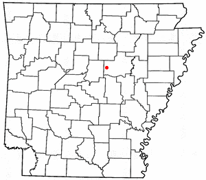
Romance is a small, unincorporated community in White County, Arkansas, United States. It's located in the central part of the county.
The community sits about halfway between the towns of Rose Bud to the north and El Paso to the south. Romance is also near Beebe and Mount Vernon. In 2010, about 1,772 people lived in the area that shares Romance's ZIP code (72136).
Contents
About Romance, Arkansas
Romance doesn't have exact borders, but it's mostly within Marshall and Kentucky Townships in White County.
How Romance Got Its Name
Legend says that a school teacher named the community many years ago. They thought the view from the bluffs on the eastern side of the community was very "romantic."
The Famous Post Office
The name "Romance" has helped keep the community's post office very popular. This local post office is one of several in the United States known for "love-themed" names.
It became extra famous in 1990 when it was the first place to release that year's special "Love Stamp" from the United States Postal Service. People from all over the country send their Valentine's Day cards and wedding invitations to Romance. They do this to get a special "Romance" postmark.
Sometimes, people even have small weddings at the post office building. However, the post office itself doesn't officially offer wedding services.
Getting Around Romance
Romance is located along two important Arkansas state highways.
- Highway 5: This road runs north and south through central Arkansas. It goes north all the way to the Missouri state line. South of Romance, it connects to U.S. Highway 67 in Cabot.
- Highway 31: This highway also runs north and south. It starts in Romance at Highway 5 and goes south towards Pine Bluff.
Most of the smaller roads in the area are managed by the White County Road Department. Hilltop Acres is one of these roads. It goes through the center of Romance and connects to both Highway 5 and Highway 31. This road passes by the old Romance Store, which used to be where the post office was. The post office moved to a new spot on Highway 31 in the early 1990s.
Major County Roads
Four main county roads serve the wider Romance area:
- Blackjack Mountain Road (White County Road 149): This paved road runs east and west, south of Highway 31. It's about 6.5 miles long. Its name comes from the blackjack oak trees found in the hills nearby.
- Romance Road (White County Road 26): This is an unpaved road that goes east and west. It starts near the center of Romance and ends near the Quattlebaum Cemetery in Gravel Hill.
- Kentucky Valley Road (White County Road 157): This paved road mostly travels north and northeast from the center of Romance. It starts at Hilltop Acres, near the community's volunteer fire station.
- Daffodil Road: This is an unpaved road that goes north and south. It starts by connecting with Hilltop Acres.
Schools in Romance
Most children in the Romance area attend schools in the Rose Bud Public School District. This district serves students from pre-kindergarten all the way through twelfth grade in nearby Rose Bud.
The school district in Romance joined with the Rose Bud district in the 1950s. Romance had its own local school as early as 1895, called the Harper School.
Some parts of eastern Romance are part of the Beebe Public School District. Other areas, especially near Highway 310, are part of the Mount Vernon–Enola School District.
 | William L. Dawson |
 | W. E. B. Du Bois |
 | Harry Belafonte |

