
Cabot, Arkansas facts for kids
Quick facts for kids
Cabot, Arkansas
|
|||
|---|---|---|---|
|
|||

Location in Lonoke County, Arkansas
|
|||

Cabot, Arkansas
Location in the United States
|
|||
| Country | United States | ||
| State | Arkansas | ||
| County | Lonoke | ||
| Founded | 1873 | ||
| Incorporated | 1891 | ||
| Area | |||
| • City | 20.78 sq mi (53.82 km2) | ||
| • Land | 20.68 sq mi (53.57 km2) | ||
| • Water | 0.10 sq mi (0.25 km2) | ||
| Elevation | 299 ft (91 m) | ||
| Population
(2020)
|
|||
| • City | 26,569 | ||
| • Density | 1,284.58/sq mi (495.99/km2) | ||
| • Metro | 685,488 (Little Rock) | ||
| Time zone | UTC-6 (CST) | ||
| • Summer (DST) | UTC-5 (CDT) | ||
| ZIP code |
72023
|
||
| Area code(s) | 501 | ||
| FIPS code | 05-10300 | ||
| GNIS feature ID | 2403962 | ||


Cabot is the biggest city in Lonoke County, Arkansas, United States. In 2020, about 26,569 people lived there. This makes it one of Arkansas's largest cities. Cabot is also part of the bigger Little Rock-North Little Rock-Conway metropolitan area.
Contents
History of Cabot
Early Days Before the City
Before Cabot was a city, a sad event happened in 1862. Around 1,500 Confederate soldiers died from a sickness called typhoid. They were camped nearby at Camp Nelson.
Later, in 1905, these soldiers were moved to a new cemetery. Marble headstones were placed for each grave. A tall marble monument was also put up to honor them. Since 1982, volunteers from Cabot have helped take care of this cemetery.
How Cabot Began
Cabot started as a small town in 1873. It grew around a train station on the Cairo & Fulton Railroad. The town was likely named after George Cabot Ward, a railroad manager.
The first church, First Baptist Church, opened in 1876. Cabot United Methodist Church followed in 1881. In 1885, the first newspaper, "The Guard," was published. Businesses like general stores, drugstores, and a hotel grew near the railroad. The Bank of Cabot opened in 1903. Cabot officially became a city on November 9, 1891.
For a long time, Austin was a bigger city in Lonoke County. But Cabot started to grow a lot in the 1950s and 1960s. This was partly because the Little Rock Air Force Base opened nearby in 1955. Also, many families moved to Cabot from bigger cities. They were looking for new homes and good schools.
Cabot as a "Bedroom Community"
In the 1970s, many families started moving to smaller towns around Little Rock. These towns included Cabot, Benton, and Conway. People often chose these towns because they had good schools.
Cabot became a "bedroom community." This means many people live in Cabot but travel to bigger cities like Little Rock for work. About 40% of military families from the Little Rock Air Force Base live in Cabot. They like the quality of life and good schools here. This growth has made Cabot a "boomtown," meaning it's growing very fast.
Because more people moved to Cabot, the city had more money from taxes. This helped the Cabot School District become one of the best in Arkansas. Today, the Cabot School District covers most of northern Lonoke County. This area is home to Cabot, Ward, and Austin, which are some of Arkansas's fastest-growing communities.
Recent Events in Cabot

On March 29, 1976, a strong tornado hit downtown Cabot. Five people sadly died, and many buildings were destroyed. When the city rebuilt, they created City Plaza. This new area has a city hall, police station, and a library.
Cabot's population has grown a lot since the 1980s. It went from under 5,000 people to over 26,000 today. Many new homes and neighborhoods have been built.
On August 10, 2006, Cabot Junior High School North had a big fire. It was thought to be an electrical fire. Even though 100 people were inside, no one was hurt. The building was completely destroyed. It was rebuilt and opened again about three years later.
Getting Around Cabot
Major ways to travel in and near Cabot include the railroad, which is now owned by Union Pacific. There's also the "old highway to St. Louis," which is now Arkansas Highway 367. Interstate 57/US Highway 67/167 also pass through the city. Long ago, Cabot was a stop on the Butterfield Overland Stagecoach Route.
Geography of Cabot
Cabot is in the northwest part of Lonoke County. The city of Austin is just northeast of Cabot. Interstate 57 and U.S. Routes 67 and 167 go through the northwest side of Cabot. These highways lead northeast to Searcy (about 26 miles away) and southwest to Little Rock (about 22 miles away), which is the state capital. Jacksonville is about 9 miles southwest of Cabot.
Cabot covers a total area of about 20.6 square miles (53.3 square kilometers). Most of this area is land, with a small part being water.
Cabot's Weather
Cabot has a climate with hot, humid summers. Winters are usually mild to cool. This type of weather is called a humid subtropical climate.
| Climate data for Cabot, Arkansas, 1991–2020 normals, extremes 1965–present | |||||||||||||
|---|---|---|---|---|---|---|---|---|---|---|---|---|---|
| Month | Jan | Feb | Mar | Apr | May | Jun | Jul | Aug | Sep | Oct | Nov | Dec | Year |
| Record high °F (°C) | 80 (27) |
83 (28) |
91 (33) |
94 (34) |
98 (37) |
106 (41) |
112 (44) |
110 (43) |
106 (41) |
96 (36) |
87 (31) |
79 (26) |
112 (44) |
| Mean maximum °F (°C) | 70.0 (21.1) |
73.8 (23.2) |
81.1 (27.3) |
84.5 (29.2) |
89.3 (31.8) |
94.6 (34.8) |
98.8 (37.1) |
99.2 (37.3) |
94.9 (34.9) |
87.2 (30.7) |
79.0 (26.1) |
70.5 (21.4) |
101.0 (38.3) |
| Mean daily maximum °F (°C) | 51.2 (10.7) |
55.7 (13.2) |
64.5 (18.1) |
73.3 (22.9) |
80.8 (27.1) |
88.5 (31.4) |
92.4 (33.6) |
91.9 (33.3) |
86.4 (30.2) |
75.8 (24.3) |
63.5 (17.5) |
53.7 (12.1) |
73.1 (22.9) |
| Daily mean °F (°C) | 39.6 (4.2) |
43.3 (6.3) |
51.7 (10.9) |
60.2 (15.7) |
69.2 (20.7) |
77.3 (25.2) |
80.8 (27.1) |
79.9 (26.6) |
73.6 (23.1) |
61.8 (16.6) |
50.5 (10.3) |
42.3 (5.7) |
60.9 (16.0) |
| Mean daily minimum °F (°C) | 27.9 (−2.3) |
30.9 (−0.6) |
39.0 (3.9) |
47.1 (8.4) |
57.5 (14.2) |
66.1 (18.9) |
69.2 (20.7) |
67.9 (19.9) |
60.7 (15.9) |
47.9 (8.8) |
37.5 (3.1) |
30.9 (−0.6) |
48.6 (9.2) |
| Mean minimum °F (°C) | 13.2 (−10.4) |
17.5 (−8.1) |
22.9 (−5.1) |
32.7 (0.4) |
42.4 (5.8) |
55.6 (13.1) |
61.5 (16.4) |
59.5 (15.3) |
46.1 (7.8) |
31.7 (−0.2) |
22.0 (−5.6) |
16.5 (−8.6) |
10.3 (−12.1) |
| Record low °F (°C) | −5 (−21) |
−3 (−19) |
11 (−12) |
24 (−4) |
35 (2) |
46 (8) |
51 (11) |
49 (9) |
35 (2) |
24 (−4) |
11 (−12) |
−7 (−22) |
−7 (−22) |
| Average precipitation inches (mm) | 3.55 (90) |
4.42 (112) |
5.20 (132) |
5.25 (133) |
6.11 (155) |
3.64 (92) |
3.26 (83) |
3.82 (97) |
3.67 (93) |
4.17 (106) |
5.19 (132) |
5.05 (128) |
53.33 (1,353) |
| Average snowfall inches (cm) | 0.7 (1.8) |
0.9 (2.3) |
0.4 (1.0) |
0.0 (0.0) |
0.0 (0.0) |
0.0 (0.0) |
0.0 (0.0) |
0.0 (0.0) |
0.0 (0.0) |
0.0 (0.0) |
0.0 (0.0) |
0.1 (0.25) |
2.1 (5.35) |
| Average precipitation days (≥ 0.01 in) | 7.4 | 7.6 | 8.8 | 9.1 | 9.8 | 7.1 | 7.4 | 6.8 | 5.5 | 6.9 | 7.8 | 8.0 | 92.2 |
| Average snowy days (≥ 0.1 in) | 0.4 | 0.5 | 0.3 | 0.0 | 0.0 | 0.0 | 0.0 | 0.0 | 0.0 | 0.0 | 0.1 | 0.1 | 1.4 |
| Source 1: NOAA | |||||||||||||
| Source 2: National Weather Service | |||||||||||||
People Living in Cabot
| Historical population | |||
|---|---|---|---|
| Census | Pop. | %± | |
| 1880 | 154 | — | |
| 1900 | 294 | — | |
| 1910 | 441 | 50.0% | |
| 1920 | 447 | 1.4% | |
| 1930 | 684 | 53.0% | |
| 1940 | 741 | 8.3% | |
| 1950 | 1,147 | 54.8% | |
| 1960 | 1,321 | 15.2% | |
| 1970 | 2,903 | 119.8% | |
| 1980 | 4,806 | 65.6% | |
| 1990 | 8,319 | 73.1% | |
| 2000 | 15,261 | 83.4% | |
| 2010 | 23,776 | 55.8% | |
| 2020 | 26,569 | 11.7% | |
| U.S. Decennial Census | |||
2020 Population Count
In 2020, the city of Cabot had 26,569 people. There were 9,780 households and 6,967 families living there.
| Race | Number | Percentage |
|---|---|---|
| White (not Hispanic) | 21,936 | 82.56% |
| Black or African American (not Hispanic) | 761 | 2.86% |
| Native American | 122 | 0.46% |
| Asian | 446 | 1.68% |
| Pacific Islander | 26 | 0.1% |
| Other/Mixed | 1,710 | 6.44% |
| Hispanic or Latino | 1,568 | 5.9% |
2010 Population Count
In 2010, Cabot had 23,776 people. There were 5,432 households. About 47.1% of these households had kids under 18. Most households (65.7%) were married couples.
The average household had 2.78 people. The average family had 3.14 people. About 31.5% of the population was under 18. About 7.9% were 65 or older. The average age in Cabot was 32 years.
The average income for a household was $49,389. For families, it was $53,933. About 7.1% of all people in Cabot lived below the poverty line.
Fun Things to Do in Cabot
Cabot has a movie theater and many restaurants. There are also places for sports and community groups. A new library and meeting center opened in 2015. The city has golf courses at Greystone Country Club and Rolling Hills Country Club. These clubs and the Veterans of Foreign Wars post are the only places in Cabot where alcohol can be sold.
One of Cabot's biggest events is Cabotfest. It's a community fair held downtown every October. It has become very popular as the city has grown. Another event is Strawberry Fest in the spring. In the past, this area was known for growing lots of strawberries.
A TV show called Man vs. Food visited Cabot's Mean Pig BBQ. The host, Adam Richman, tried a super spicy barbecue sauce challenge there!
Cabot also has many churches, about 43 in total.
Schools in Cabot
Cabot Public Schools teaches students from Cabot, Austin, and Ward. It also serves most of northern Lonoke County. The Cabot Public School District is known for supporting military families, especially those from the Little Rock Air Force Base.
Famous People from Cabot
- George W. Granberry (1848 – 1912), a doctor, newspaper editor, and politician.
- Bryce Mitchell, a UFC fighter.
- Terri Utley, who was Miss Arkansas USA in 1982 and Miss USA 1982.
- Eddie Joe Williams, a former mayor of Cabot and state senator.
- Cody Wilson, who created an early 3D-printable gun.
Images for kids
-
Flag of Cabot, Arkansas
-
City seal of Cabot, AR
-
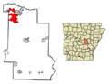
Location in Lonoke County, Arkansas
See also
 In Spanish: Cabot (Arkansas) para niños
