Cleburne County, Arkansas facts for kids
Quick facts for kids
Cleburne County
|
|
|---|---|

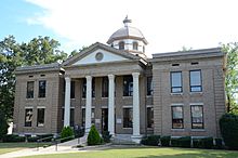
Cleburne County Courthouse in Heber Springs, Arkansas
|
|

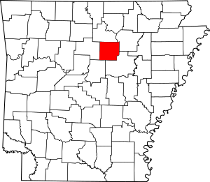
Location within the U.S. state of Arkansas
|
|
 Arkansas's location within the U.S. |
|
| Country | |
| State | |
| Founded | February 20, 1883 |
| Named for | Maj. Gen. Patrick Cleburne |
| Seat | Heber Springs |
| Largest city | Heber Springs |
| Area | |
| • Total | 592 sq mi (1,530 km2) |
| • Land | 554 sq mi (1,430 km2) |
| • Water | 38 sq mi (100 km2) 6.5%% |
| Population
(2020)
|
|
| • Total | 24,711 |
| • Density | 41.74/sq mi (16.117/km2) |
| Time zone | UTC−6 (Central) |
| • Summer (DST) | UTC−5 (CDT) |
| Congressional district | 2nd |
Cleburne County is a county located in the state of Arkansas. In 2020, about 24,711 people lived here. The main city and county seat is Heber Springs.
Cleburne County was created on February 20, 1883. It was the very last of Arkansas's 75 counties to be formed. The county is named after Confederate Major-General Patrick Cleburne. Cleburne is also known as a "dry county." This means that selling alcohol is not allowed there.
Contents
Geography of Cleburne County
Cleburne County covers a total area of about 592 square miles. Most of this area, about 554 square miles, is land. The remaining 38 square miles (6.5%) is water. A big part of the water area is Greers Ferry Lake. This lake also stretches into the nearby Van Buren County.
Main Roads in Cleburne County
Here are some of the important highways that run through Cleburne County:
 Arkansas Highway 5
 Arkansas Highway 16
 Arkansas Highway 25
 Arkansas Highway 25B
 Arkansas Highway 25S
 Arkansas Highway 87
 Arkansas Highway 92
 Arkansas Highway 107
 Arkansas Highway 110
 Arkansas Highway 124
 Arkansas Highway 210
Arkansas Highway 225
Neighboring Counties
Cleburne County shares borders with these other counties:
- Stone County (to the north)
- Independence County (to the northeast)
- White County (to the southeast)
- Faulkner County (to the southwest)
- Van Buren County (to the west)
Population Information
The population of Cleburne County has changed over the years. Here's a look at how many people have lived there during different census counts:
| Historical population | |||
|---|---|---|---|
| Census | Pop. | %± | |
| 1890 | 7,884 | — | |
| 1900 | 9,628 | 22.1% | |
| 1910 | 11,903 | 23.6% | |
| 1920 | 12,696 | 6.7% | |
| 1930 | 11,373 | −10.4% | |
| 1940 | 13,134 | 15.5% | |
| 1950 | 11,487 | −12.5% | |
| 1960 | 9,059 | −21.1% | |
| 1970 | 10,349 | 14.2% | |
| 1980 | 16,909 | 63.4% | |
| 1990 | 19,411 | 14.8% | |
| 2000 | 24,046 | 23.9% | |
| 2010 | 25,970 | 8.0% | |
| 2020 | 24,711 | −4.8% | |
| 2023 (est.) | 25,445 | −2.0% | |
| U.S. Decennial Census 1790–1960 1900–1990 1990–2000 2010 |
|||
2020 Census Details
In 2020, there were 24,711 people living in Cleburne County. These people made up 10,783 households and 7,230 families.
Here's a breakdown of the different racial groups in Cleburne County, based on the 2020 census:
| Race | Number | Percentage |
|---|---|---|
| White (not Hispanic) | 22,748 | 92.06% |
| Black or African American (not Hispanic) | 56 | 0.23% |
| Native American | 112 | 0.45% |
| Asian | 96 | 0.39% |
| Pacific Islander | 11 | 0.04% |
| Other/Mixed | 1,056 | 4.27% |
| Hispanic or Latino | 632 | 2.56% |
Communities in Cleburne County
Cleburne County has several cities, towns, and other communities where people live.
Cities
- Fairfield Bay (most of it is in Van Buren County)
- Greers Ferry
- Heber Springs (This is the county seat, where the main government offices are)
- Quitman (part of this city is in Faulkner County)
Towns
Census-designated place
- Tumbling Shoals (This is a special area that the census bureau counts as a place, but it's not officially a city or town.)
Other Unincorporated Communities
- Drasco (These are small communities that are not officially part of a city or town.)
Townships
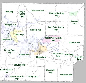
Counties in Arkansas are divided into smaller areas called townships. Here are the townships in Cleburne County: Townships in Arkansas are the divisions of a county. Each township includes unincorporated areas; some may have incorporated cities or towns within part of their boundaries. Arkansas townships have limited purposes in modern times. However, the United States Census does list Arkansas population based on townships (sometimes referred to as "county subdivisions" or "minor civil divisions"). Townships are also of value for historical purposes in terms of genealogical research. Each town or city is within one or more townships in an Arkansas county based on census maps and publications. The townships of Cleburne County are listed below; listed in parentheses are the cities, towns, and/or census-designated places that are fully or partially inside the township.
- California
- Center Post
- Clayton
- East Peter Creek
- Francis
- Giles (Greers Ferry)
- Grassey (Concord)
- Healing Springs
- Heber (most of Heber Springs)
- McJester
- Morgan (part of Fairfield Bay)
- Mountain
- North Cadron (part of Quitman)
- Pickens
- Pine
- Piney
- Poff
- Saline (Higden)
- South Cadron (part of Quitman)
- Sugar Camp
- Sugar Loaf
- Valley (part of Heber Springs)
- West Peter Creek (Tumbling Shoals)
- Wilburn
See also
 In Spanish: Condado de Cleburne (Arkansas) para niños
 | William M. Jackson |
 | Juan E. Gilbert |
 | Neil deGrasse Tyson |


