Greers Ferry Lake facts for kids
Quick facts for kids Greers Ferry Lake |
|
|---|---|

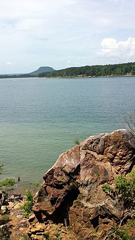
Lake with Sugarloaf Mountain visible on the horizon
|
|
| Location | Cleburne / Van Buren counties, Arkansas, US |
| Coordinates | 35°32′02″N 92°07′47″W / 35.5339°N 92.1298°W |
| Type | reservoir |
| Primary inflows | Little Red River |
| Primary outflows | Little Red River |
| Basin countries | United States |
| Surface area | 40,500 acres (164 km2) |
| Max. depth | 486 ft (148 m) |
Greers Ferry Lake is a large reservoir (a man-made lake) in Northern Arkansas. It was created by the Greers Ferry Dam. This dam was built by the United States Army Corps of Engineers. The lake is located about 60 miles (97 km) north of Little Rock. It is a very popular place for outdoor fun and activities.
Contents
Exploring Greers Ferry Lake
How the Lake Was Formed
Greers Ferry Lake is actually made of two main parts. These parts are connected by a narrow, water-filled area called the Narrows. Together, the lake covers about 40,500 acres (164 km²). Its shoreline stretches for over 340 miles.
Before the lake was built, a town named Higden was in the valley. The farmers there often had problems with floods. So, the land was bought, and the people moved away. The town was then allowed to flood. Many people say that old homes and buildings are still standing under the water today! Some roads that used to be in town now go right into the lake. These old roads are even used as boat ramps now.
Keeping the Lake Clean
In 1969, a local resident named Carl Garner started an important cleanup effort. He organized the first annual litter cleanup for Greers Ferry Lake. This idea was so successful that it led to the "Great Arkansas Cleanup" in 1990. This bigger cleanup event was based on the model that Mr. Garner started at Greers Ferry Lake.
Lake Levels and Flooding
The normal water level for Greers Ferry Lake is 461.3 feet (140.6 m) above sea level. The lake can still make electricity when its water level is as low as 435.0 feet (132.6 m). The lake has flooded several times over the years. In 1973, the water reached 483.95 feet (147.51 m). In 1982, it went even higher, above 485 feet (148 m). In April 2008, the lake topped its previous high from 1982. On April 11, 2008, the lake reached over 486 feet (148 m). This was only a few feet away from many local houses.
Fun Activities at Greers Ferry Lake
Since Greers Ferry Lake was formed in the early 1960s, tourism has grown a lot. The town of Heber Springs has seen its population grow to over 6,000 people. Many nice neighborhoods have been built around the lake since the 1970s.
There are many fun things to do at the lake. People enjoy swimming, cliff diving, boating, fishing, and scuba diving. Camping and other water activities are also very popular. The Little Red River flows out from under the dam. This water is cool and is now famous for rainbow trout fishing. It has become a favorite fishing spot all year round. You can find several campgrounds and boat docks that offer direct access to the river.
 | DeHart Hubbard |
 | Wilma Rudolph |
 | Jesse Owens |
 | Jackie Joyner-Kersee |
 | Major Taylor |


