
Van Buren County, Arkansas facts for kids
Quick facts for kids
Van Buren County
|
|
|---|---|
    Clockwise from top: Van Buren County Courthouse in downtown Clinton, Middle Fork of the Little Red River Bridge, Greers Ferry Lake at Fairfield Bay, a hill near Bee Branch
|
|

Location within the U.S. state of Arkansas
|
|
 Arkansas's location within the U.S. |
|
| Country | |
| State | |
| Founded | November 11, 1833 |
| Named for | Martin Van Buren |
| Seat | Clinton |
| Largest city | Clinton |
| Area | |
| • Total | 724 sq mi (1,880 km2) |
| • Land | 708 sq mi (1,830 km2) |
| • Water | 16 sq mi (40 km2) 2.2%% |
| Population
(2020)
|
|
| • Total | 15,796 |
| • Density | 21.818/sq mi (8.424/km2) |
| Time zone | UTC−6 (Central) |
| • Summer (DST) | UTC−5 (CDT) |
| Congressional district | 2nd |
Van Buren County is a special area in the state of Arkansas, USA. It's like a big neighborhood with its own local government. In 2020, about 15,796 people lived here.
The main town and center of the county is Clinton. Van Buren County was created a long time ago, on November 11, 1833. It was named after Martin Van Buren. He was the Vice President when the county was formed. Later, he became a President.
It's important not to mix up Van Buren County with the city of Van Buren. That city is about 100 miles west of the county. It's in a different area called Crawford County.
Contents
Exploring Van Buren County's Geography
Van Buren County covers a total area of about 724 square miles. Most of this area, about 708 square miles, is land. The rest, about 16 square miles, is water. This means rivers, lakes, and streams make up a small part of the county.
Main Roads and Travel Routes
Many important roads help people travel through Van Buren County. These roads connect towns and make it easy to get around.
 U.S. Highway 65
 Arkansas Highway 9
 Arkansas Highway 16
 Arkansas Highway 27
 Arkansas Highway 92
 Arkansas Highway 95
 Arkansas Highway 110
 Arkansas Highway 124
 Arkansas Highway 254
 Arkansas Highway 285
 Arkansas Highway 330
 Arkansas Highway 336
 Arkansas Highway 337
 Arkansas Highway 356
Public Transportation Options
For those who travel by bus, Jefferson Lines offers service. This company provides bus routes that connect different places.
Neighboring Counties
Van Buren County shares its borders with several other counties. These are like its neighbors on a map.
- Searcy County (north)
- Stone County (northeast)
- Cleburne County (east)
- Faulkner County (southeast)
- Conway County (southwest)
- Pope County (west)
Protected Natural Areas
Part of the Ozark National Forest is located in Van Buren County. A national forest is a large area of land protected by the government. It's kept natural for wildlife and outdoor activities.
Understanding Van Buren County's Population
The number of people living in Van Buren County has changed over time. In 2020, the county had 15,796 residents. There were 6,813 households, which are groups of people living together. Also, there were 4,631 families.

Who Lives in Van Buren County?
Most people in Van Buren County are White. Other groups also live here, making the county a mix of different backgrounds.
| Group | Number | Percentage |
|---|---|---|
| White (not Hispanic) | 14,319 | 90.65% |
| Black or African American (not Hispanic) | 71 | 0.45% |
| Native American | 110 | 0.7% |
| Asian | 56 | 0.35% |
| Other/Mixed backgrounds | 739 | 4.68% |
| Hispanic or Latino | 501 | 3.17% |
Towns and Communities
Van Buren County has several towns and communities. These are places where people live and work.
Cities in the County
- Clinton is the county seat. This means it's the main administrative center.
- Fairfield Bay is another city. Part of it is also in Cleburne County.
Smaller Towns
- Damascus is a town that also extends into Faulkner County.
- Shirley is another town in Van Buren County.
Special Census Areas
These are areas that are like towns but are counted differently for census purposes.
Other Small Communities
Many other small, unincorporated communities are found throughout the county. These are often small groups of homes or businesses.
- Alread
- Archey Valley
- Austin
- Botkinburg
- Chimes
- Choctaw
- Choctaw Pines
- Claude
- Copeland
- Crabtree
- Culpepper
- Dabney
- Eglantine
- Elba
- Fairbanks
- Formosa
- Gravesville
- Gravel Hill
- Green Tree
- Half Moon
- Morganton
- Old Botkinburg
- Palisades
- Pee Dee
- Plant
- Pleasant Grove
- Rabbit Ridge
- Rex
- Rocky Hill
- Rumley
- Rupert
- Scotland
- Southside
- Stumptoe
- Sulphur Springs
- Walnut Grove
- Whipple
- Woodlum
- Zion Hill
County Townships

Van Buren County is divided into smaller areas called townships. These help with local organization and services. Each township has its own population and area.
Education in Van Buren County
Several school districts serve the students in Van Buren County. These districts provide education from elementary to high school.
- Clinton School District
- Quitman School District
- Searcy County School District
- Shirley School District
- South Side-Bee Branch School District
- West Side School District
Images for kids
-
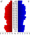
Age pyramid Van Buren County
-
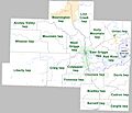
Townships in Van Buren County, Arkansas, as of 2010
See also
 In Spanish: Condado de Van Buren (Arkansas) para niños
