Searcy County, Arkansas facts for kids
Quick facts for kids
Searcy County
|
||
|---|---|---|

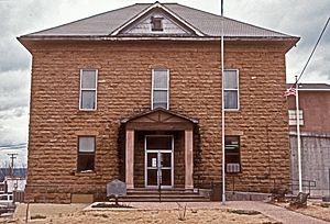
Searcy County Courthouse
|
||
|
||

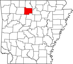
Location within the U.S. state of Arkansas
|
||
 Arkansas's location within the U.S. |
||
| Country | ||
| State | ||
| Founded | December 13, 1838 | |
| Named for | Richard Searcy | |
| Seat | Marshall | |
| Largest city | Marshall | |
| Area | ||
| • Total | 669 sq mi (1,730 km2) | |
| • Land | 666 sq mi (1,720 km2) | |
| • Water | 2.4 sq mi (6 km2) 0.4%% | |
| Population
(2020)
|
||
| • Total | 7,828 | |
| • Density | 11.701/sq mi (4.518/km2) | |
| Time zone | UTC−6 (Central) | |
| • Summer (DST) | UTC−5 (CDT) | |
| Congressional district | 1st | |
| Website | https://searcyco.org/ | |
Searcy County is a county in the state of Arkansas. In 2020, about 7,828 people lived here. The main town and county seat is Marshall.
The county was created on December 13, 1838. It was formed from a part of Marion County. It was named after Richard Searcy, who was an important judge in the early Arkansas Territory. Interestingly, the city of Searcy, Arkansas is about 70 miles away and has never been part of Searcy County. In Searcy County, selling alcohol is not allowed.
Contents
History of Searcy County
During the American Civil War, many people in Searcy County supported the Union (the northern states). They even formed a group called the "Arkansas Peace Society" to show their support.
The Chocolate Roll Capital
Searcy County is famous for a special dessert called the Chocolate Roll. It's not very well known outside of this area.
A Chocolate Roll is made from pie dough. This dough is spread with a mix of cocoa powder, shortening, and sugar. Then, it's rolled up and baked.
In 2012, the Greater Searcy County Chamber of Commerce declared Searcy County the "Chocolate Roll Capital of the World™". They even registered this as a trademark.
Since 2012, Marshall High School has hosted an annual Chocolate Roll Festival. This festival includes a "World Champion Chocolate Roll Contest."
Geography of Searcy County
Searcy County covers a total area of about 669 square miles. Most of this area, about 666 square miles, is land. Only a small part, about 2.4 square miles, is water.
Main Roads in Searcy County
These are the most important highways that go through Searcy County:
 U.S. Highway 65
 Arkansas Highway 14
 Arkansas Highway 16
 Arkansas Highway 27
 Arkansas Highway 66
 Arkansas Highway 74
 Arkansas Highway 235
 Arkansas Highway 333
 Arkansas Highway 374
 Arkansas Highway 377
Neighboring Counties
Searcy County shares borders with these other counties:
- Marion County (to the north)
- Baxter County (to the northeast)
- Stone County (to the east)
- Van Buren County (to the south)
- Pope County (to the southwest)
- Newton County (to the west)
- Boone County (to the northwest)
Protected Natural Areas
Parts of these national protected areas are found in Searcy County:
Population Data
| Historical population | |||
|---|---|---|---|
| Census | Pop. | %± | |
| 1840 | 936 | — | |
| 1850 | 1,979 | 111.4% | |
| 1860 | 5,271 | 166.3% | |
| 1870 | 5,614 | 6.5% | |
| 1880 | 7,278 | 29.6% | |
| 1890 | 9,664 | 32.8% | |
| 1900 | 11,988 | 24.0% | |
| 1910 | 14,825 | 23.7% | |
| 1920 | 14,590 | −1.6% | |
| 1930 | 11,056 | −24.2% | |
| 1940 | 11,942 | 8.0% | |
| 1950 | 10,424 | −12.7% | |
| 1960 | 8,124 | −22.1% | |
| 1970 | 7,731 | −4.8% | |
| 1980 | 8,847 | 14.4% | |
| 1990 | 7,841 | −11.4% | |
| 2000 | 8,261 | 5.4% | |
| 2010 | 8,195 | −0.8% | |
| 2020 | 7,828 | −4.5% | |
| 2023 (est.) | 7,806 | −4.7% | |
| U.S. Decennial Census 1790–1960 1900–1990 1990–2000 2010 |
|||
2020 Census Information
In 2020, the census showed that 7,828 people lived in Searcy County. There were 3,327 households and 2,333 families.
Here's a look at the different groups of people living in Searcy County:
| Group | Number | Percentage |
|---|---|---|
| White (not Hispanic) | 7,092 | 90.6% |
| Black or African American (not Hispanic) | 5 | 0.06% |
| Native American | 65 | 0.83% |
| Asian | 20 | 0.26% |
| Pacific Islander | 5 | 0.06% |
| Other/Mixed | 501 | 6.4% |
| Hispanic or Latino | 140 | 1.79% |
Schools in Searcy County
Children in Searcy County get their education from several school districts:
- Searcy County School District: This district includes Marshall High School.
- Ozark Mountain School District: This district includes St. Joe High School and St. Joe Elementary School, which are located in Searcy County.
Towns and Communities
Searcy County has several towns and communities:
Cities
Towns
Census-Designated Places
Unincorporated Communities
These are smaller communities that are not officially organized as cities or towns:
Townships
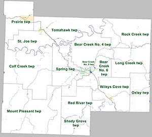
Searcy County is divided into smaller areas called townships. These help with local administration. Townships in Arkansas are the divisions of a county. Each township includes unincorporated areas; some may have incorporated cities or towns within part of their boundaries. Arkansas townships have limited purposes in modern times. However, the United States Census does list Arkansas population based on townships (sometimes referred to as "county subdivisions" or "minor civil divisions"). Townships are also of value for historical purposes in terms of genealogical research. Each town or city is within one or more townships in an Arkansas county based on census maps and publications. The townships of Searcy County are listed below; listed in parentheses are the cities, towns, and/or census-designated places that are fully or partially inside the township.
| Township | Population (2010) |
Land area (mi2) |
Geographic coordinates | |
|---|---|---|---|---|
| Bear Creek No. 4 | 989 | 46.655 | 120.8 | 35°58′16″N 92°37′26″W / 35.971174°N 92.623964°W |
| Bear Creek No. 5 | 728 | 1.479 | 3.831 | 35°54′35″N 92°38′47″W / 35.909629°N 92.646337°W |
| Bear Creek No. 6 | 913 | 24.917 | 64.53 | 35°54′16″N 92°36′32″W / 35.904425°N 92.608797°W |
| Calf Creek | 326 | 81.202 | 210.3 | 35°54′12″N 92°50′49″W / 35.903196°N 92.846919°W |
| Long Creek | 474 | 44.219 | 114.5 | 35°55′23″N 92°29′16″W / 35.923104°N 92.487694°W |
| Mount Pleasant | 465 | 108.750 | 281.7 | 35°47′22″N 92°50′34″W / 35.789412°N 92.842860°W |
| Oxley | 364 | 32.018 | 82.93 | 35°52′02″N 92°27′47″W / 35.867295°N 92.463161°W |
| Prairie | 550 | 39.793 | 103.1 | 36°03′55″N 92°53′29″W / 36.065325°N 92.891250°W |
| Red River | 321 | 33.144 | 85.84 | 35°48′55″N 92°41′14″W / 35.815267°N 92.687262°W |
| Rock Creek | 547 | 52.915 | 137.0 | 36°01′19″N 92°29′48″W / 36.021866°N 92.496667°W |
| St. Joe | 390 | 29.838 | 77.28 | 35°59′13″N 92°51′15″W / 35.986869°N 92.854089°W |
| Shady Grove | 189 | 42.834 | 110.9 | 35°44′37″N 92°39′19″W / 35.743664°N 92.655141°W |
| Spring | 588 | 46.715 | 121.0 | 35°54′17″N 92°42′38″W / 35.904585°N 92.710556°W |
| Tomahawk | 574 | 53.762 | 139.2 | 36°02′13″N 92°42′57″W / 36.036902°N 92.715763°W |
| Wileys Cove | 777 | 45.225 | 117.1 | 35°51′20″N 92°31′11″W / 35.855434°N 92.519860°W |
| Source: U.S. Census Bureau | ||||
See also
 In Spanish: Condado de Searcy para niños
 | Jessica Watkins |
 | Robert Henry Lawrence Jr. |
 | Mae Jemison |
 | Sian Proctor |
 | Guion Bluford |


