Buffalo National River facts for kids
Quick facts for kids Buffalo National River |
|
|---|---|

Buffalo National River, Arkansas
|
|
| Physical characteristics | |
| Length | 153 miles (246 km) |
| Type: | Wild, Scenic |
| Designated: | April 22, 1992 |
The Buffalo River is a beautiful river in northern Arkansas. It was the very first river in the United States to be named a National River. This means it's protected for everyone to enjoy its natural beauty.
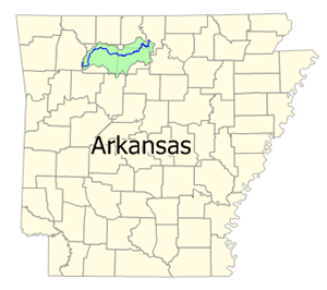
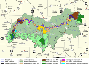
The Buffalo River is about 153 miles (246 km) long. Most of it, about 135 miles (217 km), is managed by the National Park Service and is called the Buffalo National River. The river flows from west to east through several counties: Newton, Searcy, Marion, and Baxter.
It starts in the high Boston Mountains of the Ozarks. Then it flows through different areas, eventually joining the White River. This park is special because it's home to Arkansas's only wild elk herd! Part of the river is also managed by the U.S. Forest Service as a National Scenic River and a National Wild River.
Contents
Why is the Buffalo River Protected?
The Buffalo National River was created on March 1, 1972. This important decision stopped plans to build dams on the river. A "National River" title helps keep rivers natural. It protects them from things like factories or dams that could change the river's flow. This also helps protect the plants and animals that live in and around the river. In 1975, parts of the river, totaling about 11,978 acres (48.47 km2), were named the Buffalo National River Wilderness. This gives them even more protection.
Where Does the Buffalo River Start?
The Buffalo River begins as the Main Prong of Big Buffalo Creek. This is about 15 miles (24 km) before the official park boundary in Newton County, Arkansas. The river flows north through a place called Boxley, then to Ponca. From there, it turns east and flows across northern Arkansas. Finally, it meets the White River at the border of Marion and Baxter Counties.
Some experienced canoeists and kayakers call the 15-mile (24 km) section upstream from Boxley the "Hailstone River." This part is very challenging and can only be floated when the water is high. Only people with strong whitewater skills should try it.
What Makes the River Special?
The upper part of the river has a steep slope, making the water flow fast. This section has most of the exciting whitewater rapids. You'll also see amazing natural features here, like:
- Sinkholes and caves
- Springs
- Waterfalls, including Hemmed-In-Hollow Falls, which is 209-foot (64 m) tall! It's the highest waterfall of its kind between the Southern Appalachians and the Rockies.
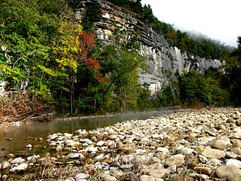
- Tall bluffs made of sandstone and limestone, some over 500-foot (150 m) high.
- Many unique rock formations.
The river's moving water also supports over 300 different kinds of fish, insects, freshwater mussels, and water plants. It's a busy underwater world!
Fun Things to Do at Buffalo National River
The Buffalo National River is a fantastic place for outdoor adventures. Many people come here for:
- Camping
- Hiking
- Canoeing and kayaking
- Fishing
You can bring your own canoe or rent one from local businesses. Camping is allowed in most areas of the park. However, there are a few places where you can't camp, like near historic buildings or too close to trails. You can camp on gravel bars and sand bars along the river, which is a unique experience! The National Park Service also has several official campgrounds.
The main office for the Buffalo National River is in Harrison, Arkansas.
Popular Places to Visit Along the River
Here are some of the main spots where you can access and enjoy the Buffalo National River:
- Boxley Bridge: This is at the upper end of the river. It's a great starting point for accessing the Upper Buffalo Wilderness Area.
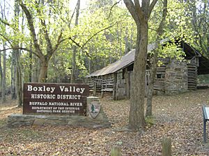
- Ponca: Here you can see the historic Beaver Jim Villines Boyhood Home. There's an old "low water" bridge where boaters need to carry their boats over.
- Steel Creek: Located upstream from the Ponca Wilderness area, offering river access.
- Kyles Landing: Downstream from the Ponca Wilderness. This area was once home to an early frontiersman.
- Erbie: Another spot with an old "low water" bridge for river access.
- Pruitt Ranger Station: On Arkansas Highway 7, with a picnic area and foot access to the river. For boat access, use Pruitt Landing.
- Pruitt Landing: Just downstream from the Ranger Station, providing boat access.
- Tyler Bend Visitor Center: This is the main public contact area, located off U.S. 65. It has a visitor center, picnic area, campground, and ranger station. You can also see the 'Colliers Homestead' here, which shows what life was like in the mountains long ago.
- Gilbert: A small town at the end of Arkansas Highway 333, offering river access.
- Dillards Ferry: Located on Arkansas Highway 14 at the bridge over the Buffalo River.
- Buffalo Point Ranger Station: At the end of Arkansas Highway 268, providing river access.
- Buffalo City: This is where the Buffalo River meets the White River. It's outside the National River boundaries but is the last take-out point for the Buffalo River. You can find boat rentals, camping, and cabins here.
 | James Van Der Zee |
 | Alma Thomas |
 | Ellis Wilson |
 | Margaret Taylor-Burroughs |


