Marion County, Arkansas facts for kids
Quick facts for kids
Marion County
|
|
|---|---|

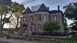
Marion County courthouse in Yellville
|
|

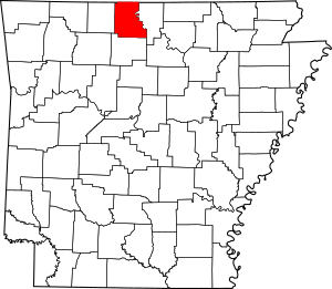
Location within the U.S. state of Arkansas
|
|
 Arkansas's location within the U.S. |
|
| Country | |
| State | |
| Founded | September 25, 1836 |
| Named for | Francis Marion |
| Seat | Yellville |
| Largest city | Bull Shoals |
| Area | |
| • Total | 640 sq mi (1,700 km2) |
| • Land | 597 sq mi (1,550 km2) |
| • Water | 43 sq mi (110 km2) 6.8%% |
| Population
(2020)
|
|
| • Total | 16,826 |
| • Estimate
(2023)
|
17,514 |
| • Density | 26.29/sq mi (10.15/km2) |
| Time zone | UTC−6 (Central) |
| • Summer (DST) | UTC−5 (CDT) |
| Congressional district | 1st |
Marion County is a place in the Ozark Mountains in Arkansas, a state in the United States. It is named after Francis Marion, a famous hero from the American Revolutionary War. People called him the "Swamp Fox."
Marion County became Arkansas's 35th county in 1836. It has one official town and four cities. Yellville is the main city, known as the county seat. There are also many smaller communities and even some ghost towns here.
The county covers about 640 square miles (1,658 square kilometers). In 2020, about 16,826 people lived here. This makes it the 42nd largest county in Arkansas by population. The land is mostly rugged with many rivers and streams. The White River and Buffalo River flow through it. You can also find parts of the Ozark National Forest and Bull Shoals-White River State Park here.
Marion County does not have any big Interstate highways. But it does have two U.S. highways and eight Arkansas state highways.
Contents
History of Marion County
Before settlers arrived, the Ozark Plateau was home to the Osage Indians for hundreds of years. The land that is now Arkansas was controlled by France starting in 1682. Then, Spain took over in 1762. In 1800, France got the land back.
In 1803, the United States bought this land from France as part of the Louisiana Purchase. This was a huge land deal! Later, in 1812, the Territory of Missouri was created. It included most of the land from the Louisiana Purchase. To manage this large area, smaller counties were formed. Marion County was once part of a much larger area called Lawrence County.
Marion County was once a big center for zinc mining. Today, you can still see the old mining sites. The ruins of the Rush Creek mining district are now a special place called the Rush Historic District. It is listed on the National Register of Historic Places.
Geography and Nature
The U.S. Census Bureau says Marion County has a total area of 640 square miles (1,658 square kilometers). About 597 square miles (1,546 square kilometers) is land. The other 43 square miles (111 square kilometers) is water, which is about 6.8% of the total area.
Neighboring Counties
Marion County shares its borders with several other counties:
- Ozark County, Missouri (to the north)
- Baxter County (to the east)
- Searcy County (to the south)
- Boone County (to the west)
- Taney County, Missouri (to the northwest)
Protected Natural Areas
Marion County is home to some beautiful protected natural areas:
- Buffalo National River (part of it)
- Buffalo National River Wilderness
- Ozark National Forest (part of it)
People of Marion County
A census is an official count of how many people live in an area. It also gathers information about them. The United States does a census every ten years.
| Historical population | |||
|---|---|---|---|
| Census | Pop. | %± | |
| 1840 | 1,325 | — | |
| 1850 | 2,308 | 74.2% | |
| 1860 | 6,192 | 168.3% | |
| 1870 | 3,979 | −35.7% | |
| 1880 | 7,907 | 98.7% | |
| 1890 | 10,390 | 31.4% | |
| 1900 | 11,377 | 9.5% | |
| 1910 | 10,203 | −10.3% | |
| 1920 | 10,154 | −0.5% | |
| 1930 | 8,876 | −12.6% | |
| 1940 | 9,464 | 6.6% | |
| 1950 | 8,609 | −9.0% | |
| 1960 | 6,041 | −29.8% | |
| 1970 | 7,000 | 15.9% | |
| 1980 | 11,334 | 61.9% | |
| 1990 | 12,001 | 5.9% | |
| 2000 | 16,140 | 34.5% | |
| 2010 | 16,653 | 3.2% | |
| 2020 | 16,826 | 1.0% | |
| 2023 (est.) | 17,514 | 5.2% | |
| U.S. Decennial Census 1790–1960 1900–1990 1990–2000 2010 |
|||
In 2020, the census showed that 16,826 people lived in Marion County. There were 6,782 households and 4,438 families.
Cities and Towns
Marion County has several communities where people live.
Cities
- Bull Shoals
- Flippin
- Summit
- Yellville (This is the county seat, the main city for county government.)
Town
Census-designated places
These are areas that are like towns but are not officially incorporated as cities or towns.
Townships
Most counties in Arkansas have many townships. But Marion County is special because it has only one township. This single township covers the entire county. Townships in Arkansas are the divisions of a county. Each township includes unincorporated areas; some may have incorporated cities or towns within part of their boundaries. Arkansas townships have limited purposes in modern times. However, the United States Census does list Arkansas population based on townships (sometimes referred to as "county subdivisions" or "minor civil divisions"). Townships are also of value for historical purposes in terms of genealogical research. Each town or city is within one or more townships in an Arkansas county based on census maps and publications. The townships of Marion County are listed below; listed in parentheses are the cities, towns, and/or census-designated places that are fully or partially inside the township.
- Marion County
Roads and Transportation
Marion County has several important roads that help people travel.
Major Highways
 US 62
US 62 US 412
 U.S. Route 62 Business
 U.S. Route 62 Spur
 Highway 14
 Highway 101
 Highway 125
 Highway 178
 Highway 202
 Highway 206
 Highway 235
 Highway 268
 Airport Highway 980
See also
 In Spanish: Condado de Marion (Arkansas) para niños
 | Mary Eliza Mahoney |
 | Susie King Taylor |
 | Ida Gray |
 | Eliza Ann Grier |


