Marion, Arkansas facts for kids
Quick facts for kids
Marion, Arkansas
|
|
|---|---|

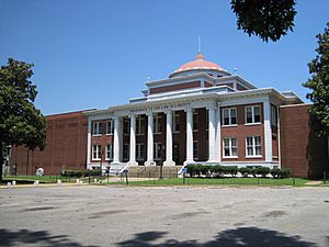
Crittenden County Courthouse
|
|

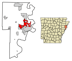
Location of Marion in Crittenden County, Arkansas.
|
|
| Country | United States |
| State | Arkansas |
| County | Crittenden |
| Incorporated | March 5, 1896 |
| Named for | Marion Tolbert |
| Area | |
| • Total | 20.12 sq mi (52.11 km2) |
| • Land | 20.04 sq mi (51.91 km2) |
| • Water | 0.08 sq mi (0.20 km2) |
| Elevation | 213 ft (65 m) |
| Population
(2020)
|
|
| • Total | 13,752 |
| • Density | 686.12/sq mi (264.91/km2) |
| Time zone | UTC−06:00 (Central (CST)) |
| • Summer (DST) | UTC−05:00 (CDT) |
| ZIP Code |
72364
|
| Area code(s) | 870 |
| FIPS code | 05-44180 |
| GNIS feature ID | 2405021 |
Marion is a city in Arkansas, United States. It is the main city, or "county seat," of Crittenden County. In 2020, about 13,752 people lived there. Marion is part of the larger Memphis area. It is the second biggest city in Crittenden County, after West Memphis.
Contents
History of Marion
Marion became an official city in 1896. But people lived in this area much earlier. From 1764 to 1803, the land was part of Louisiana (New Spain). Then it became part of Louisiana (New France). Some of the oldest land records here are from Spanish land grants. These were given out before the Louisiana Purchase in 1803. After that, the area became part of the Arkansas Territory.
In the 1830s, the Trail of Tears passed through Marion. This was when Native Americans were forced to move from their homes. They came from places like Georgia, Alabama, and Mississippi.
How Marion Got Its Name
Marion, Arkansas, was named after a person called Marion Tolbert. In 1837, two people were chosen to find a spot for a new county seat. Marion Tolbert and his wife, Temperance, gave land for this purpose. They gave the land to Crittenden County on June 25, 1837. A town was then planned out and named Marion to honor Marion Tolbert. It became the county seat of Crittenden County. Marion has been made an official city several times. The current official date is 1896.
The Sultana Steamboat Disaster
During the American Civil War, a steamboat called the Sultana exploded. This happened on April 27, 1865. The boat was carrying soldiers who had been released from prison. It was near Mound City, which is just east of Marion. About 1,500 soldiers and crew members died. This was the biggest loss of life in a boat accident in U.S. history. A special marker remembers this sad event.
Geography and Climate
Marion is in the eastern part of Crittenden County. It is next to the city of West Memphis to the south. To the north, it borders Sunset and Clarkedale.
Marion covers about 20.12 square miles (52.11 square kilometers). Most of this area is land. Only a tiny part, about 0.08 square miles (0.20 square kilometers), is water.
The city is about 11 miles west of Memphis, Tennessee. Marion has a humid subtropical climate. This means it has hot, humid summers and mild winters.
| Climate data for Memphis (Memphis Int'l), 1981−2010 normals, extremes 1872−present | |||||||||||||
|---|---|---|---|---|---|---|---|---|---|---|---|---|---|
| Month | Jan | Feb | Mar | Apr | May | Jun | Jul | Aug | Sep | Oct | Nov | Dec | Year |
| Record high °F (°C) | 79 (26) |
81 (27) |
87 (31) |
94 (34) |
99 (37) |
104 (40) |
108 (42) |
107 (42) |
103 (39) |
95 (35) |
86 (30) |
81 (27) |
108 (42) |
| Mean daily maximum °F (°C) | 49.8 (9.9) |
54.7 (12.6) |
63.9 (17.7) |
73.0 (22.8) |
81.2 (27.3) |
88.9 (31.6) |
91.6 (33.1) |
91.3 (32.9) |
85.1 (29.5) |
74.4 (23.6) |
62.6 (17.0) |
52.1 (11.2) |
72.4 (22.4) |
| Daily mean °F (°C) | 41.2 (5.1) |
45.5 (7.5) |
54.0 (12.2) |
62.9 (17.2) |
71.7 (22.1) |
79.6 (26.4) |
82.7 (28.2) |
82.0 (27.8) |
75.2 (24.0) |
64.1 (17.8) |
53.2 (11.8) |
43.6 (6.4) |
63.0 (17.2) |
| Mean daily minimum °F (°C) | 32.6 (0.3) |
36.3 (2.4) |
44.1 (6.7) |
52.9 (11.6) |
62.2 (16.8) |
70.3 (21.3) |
73.8 (23.2) |
72.7 (22.6) |
65.2 (18.4) |
53.8 (12.1) |
43.7 (6.5) |
35.1 (1.7) |
53.6 (12.0) |
| Record low °F (°C) | −8 (−22) |
−11 (−24) |
12 (−11) |
27 (−3) |
36 (2) |
48 (9) |
52 (11) |
48 (9) |
36 (2) |
25 (−4) |
9 (−13) |
−13 (−25) |
−13 (−25) |
| Average precipitation inches (mm) | 3.98 (101) |
4.39 (112) |
5.16 (131) |
5.50 (140) |
5.25 (133) |
3.63 (92) |
4.59 (117) |
2.88 (73) |
3.09 (78) |
3.98 (101) |
5.49 (139) |
5.74 (146) |
53.68 (1,363) |
| Average snowfall inches (cm) | 1.9 (4.8) |
1.3 (3.3) |
0.4 (1.0) |
0 (0) |
0 (0) |
0 (0) |
0 (0) |
0 (0) |
0 (0) |
0 (0) |
trace | 0.2 (0.51) |
3.8 (9.7) |
| Average precipitation days (≥ 0.01 in) | 9.5 | 9.2 | 10.5 | 9.6 | 10.3 | 9.0 | 8.8 | 6.8 | 7.3 | 7.5 | 9.5 | 9.7 | 107.7 |
| Average snowy days (≥ 0.1 in) | 1.2 | 0.8 | 0.4 | 0 | 0 | 0 | 0 | 0 | 0 | 0 | 0 | 0.4 | 2.8 |
| Average relative humidity (%) | 68.2 | 66.4 | 63.2 | 62.5 | 66.4 | 66.8 | 69.1 | 69.6 | 71.3 | 66.2 | 67.7 | 68.8 | 67.2 |
| Mean monthly sunshine hours | 166.6 | 173.8 | 215.3 | 254.6 | 301.5 | 320.6 | 326.9 | 307.0 | 251.2 | 245.9 | 173.0 | 151.9 | 2,888.3 |
| Percent possible sunshine | 53 | 57 | 58 | 65 | 69 | 74 | 74 | 74 | 68 | 70 | 56 | 50 | 65 |
| Source: NOAA (relative humidity 1961−1990, sun 1961−1987) | |||||||||||||
Notable People from Marion
- Sid Eudy – A famous professional wrestler known as "Sid Vicious."
- John Tate – A champion heavyweight boxer.
- Asa Hodges – A politician and lawyer.
Transportation in Marion

Major Roads
Marion has a big highway, Interstate 55/US 61, running through it. It is also close to where Interstate 40 connects. These highways cross the Mississippi River to Memphis. U.S. Highway 64 is the main road that goes east and west through the city. Arkansas Highway 77 and Highway 118 are important roads that go north and south.
Air Travel
For smaller planes, Marion uses the West Memphis Municipal Airport (KAWM). The General DeWitt Spain Airport is another airport for private planes near Memphis. For bigger commercial flights, people use Memphis International Airport. This airport is a major hub for FedEx cargo planes.
Trains
Union Pacific has a large train facility west of Marion. BNSF Railway also has a train yard in Marion. For passengers, Amtrak trains are available at Central Station in nearby Memphis. The City of New Orleans train runs twice a day. It travels north and south from Chicago to New Orleans.
Waterways
Crittenden County and West Memphis share a port on the Mississippi River. The International Port of Memphis is just across the river. It is one of the largest inland ports in the United States.
Community Life
Marion is close to Memphis and major highways. This means people in Marion can enjoy activities from a big city. But Marion still feels like a small, friendly town.
Every May, Marion hosts a festival called the Esperanza Bonanza. It has live music, a barbecue contest, a rodeo, and games for everyone. More recently, Marion started "Christmas on the Square" in early December. Local groups help put on this event.
The Woolfolk Public Library serves Marion and Crittenden County. It is named after Margaret Woolfolk, a local writer.
Being outdoors is a big part of life here. There are many youth sports and family activities. Marion is less than an hour away from 12 state parks in Arkansas, Tennessee, or Mississippi. You can also enjoy nature at the Wapanocca National Wildlife Refuge. This refuge is about 10 miles north of town. Horseshoe Lake is nearby and offers water sports.
Healthcare Services
Marion and Crittenden County are now served by Baptist Memorial Hospital-Crittenden. This hospital opened on December 13, 2018. Before that, Crittenden Regional Hospital in West Memphis served the area. It closed in 2014.
Population and People
| Historical population | |||
|---|---|---|---|
| Census | Pop. | %± | |
| 1880 | 199 | — | |
| 1940 | 758 | — | |
| 1950 | 883 | 16.5% | |
| 1960 | 881 | −0.2% | |
| 1970 | 1,431 | 62.4% | |
| 1980 | 2,996 | 109.4% | |
| 1990 | 4,391 | 46.6% | |
| 2000 | 8,901 | 102.7% | |
| 2010 | 12,345 | 38.7% | |
| 2020 | 13,752 | 11.4% | |
| U.S. Decennial Census | |||
Population in 2020
| Race | Num. | Perc. |
|---|---|---|
| White | 7,346 | 53.42% |
| Black or African American | 5,257 | 38.23% |
| Native American | 32 | 0.23% |
| Asian | 191 | 1.39% |
| Pacific Islander | 6 | 0.04% |
| Other/Mixed | 492 | 3.58% |
| Hispanic or Latino | 428 | 3.11% |
In 2020, there were 13,752 people living in Marion. There were 4,543 households and 3,198 families.
Population in 2010
In 2010, Marion had 12,345 people and 4,278 households. The city had about 604 people per square mile. Most people were White (68.1%). About 28% were Black or African American. Other groups included Native American (0.4%), Asian (1.5%), and people of two or more races (1.4%). About 2.0% of the population was Hispanic or Latino.
Most adults (88%) had a high school diploma. About 28% had a college degree or higher. A small number of people (2.5%) were born outside the U.S. About 4.4% spoke a language other than English at home. Most homes (71.3%) were owned by the people living in them. The average household income was $60,051. About 7.3% of the people lived below the poverty line.
Education in Marion
Mid-South Community College in West Memphis serves Crittenden County. This college works with several universities. Students can earn bachelor's and master's degrees there.
Public Schools
The Marion School District serves most of the city. A small part of Marion is in the West Memphis School District.
Schools in the Marion district include:
- Visual and Performing Arts Magnet School (Pre-K to 6th grade)
- Math, Science, and Technology Magnet School (Kindergarten to 6th grade)
- Herbert Carter Global Magnet School (Kindergarten to 6th grade)
- Marion Middle School (7th grade)
- Marion Jr. High School (8th to 9th grade)
- Marion High School (10th to 12th grade)
The only high school in the West Memphis district is Academies of West Memphis. It used to be called West Memphis High School.
Private Schools
- West Memphis Christian School, for students from Pre-K to 12th grade.
- Crittenden Pentecostal Academy, for students from Kindergarten to 12th grade.
- St. Michael's Catholic School, for students from Pre-K to 6th grade.
See also
 In Spanish: Marion (Arkansas) para niños
 | Calvin Brent |
 | Walter T. Bailey |
 | Martha Cassell Thompson |
 | Alberta Jeannette Cassell |

