Ozark County, Missouri facts for kids
Quick facts for kids
Ozark County
|
|
|---|---|

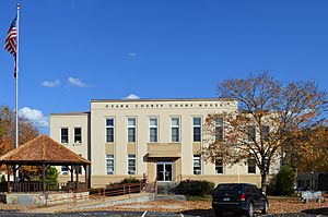
Ozark County Courthouse in Gainesville
|
|

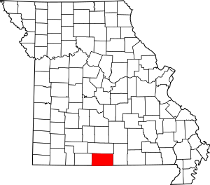
Location within the U.S. state of Missouri
|
|
 Missouri's location within the U.S. |
|
| Country | |
| State | |
| Founded | January 29, 1841 |
| Named for | Ozark Mountains |
| Seat | Gainesville |
| Largest city | Gainesville |
| Area | |
| • Total | 755 sq mi (1,960 km2) |
| • Land | 745 sq mi (1,930 km2) |
| • Water | 10 sq mi (30 km2) 1.4% |
| Population
(2020)
|
|
| • Total | 8,553 |
| • Density | 11.328/sq mi (4.3739/km2) |
| Time zone | UTC−6 (Central) |
| • Summer (DST) | UTC−5 (CDT) |
| Congressional district | 8th |
Ozark County is a place in the southern part of Missouri, a state in the United States. It's called a county. In 2020, about 8,553 people lived there. The biggest town and the main office for the county government is Gainesville.
Ozark County was created on January 29, 1841. It was named after the Ozark Mountains. For a short time, from 1843 to 1845, it was called Decatur County. This was in honor of Commodore Stephen Decatur. But then, the name Ozark County was brought back.
Contents
Geography of Ozark County
Ozark County covers a total area of about 755 square miles. Most of this area, about 745 square miles, is land. The remaining 10 square miles is water. The state of Arkansas is right to the south of Ozark County.
Neighboring Counties
Ozark County shares its borders with several other counties:
- Douglas County to the north
- Howell County to the east
- Fulton County, Arkansas to the southeast
- Baxter County, Arkansas to the south
- Marion County, Arkansas to the southwest
- Taney County to the west
Main Roads
These are the most important highways that run through Ozark County:
 U.S. Route 160
 Route 5
 Route 95
 Route 142
 Route 181
Protected Natural Areas
A part of the Mark Twain National Forest is located in Ozark County. This is a large area of protected forest land.
People of Ozark County (Demographics)
| Historical population | |||
|---|---|---|---|
| Census | Pop. | %± | |
| 1850 | 2,294 | — | |
| 1860 | 2,447 | 6.7% | |
| 1870 | 3,363 | 37.4% | |
| 1880 | 5,618 | 67.1% | |
| 1890 | 9,795 | 74.4% | |
| 1900 | 12,145 | 24.0% | |
| 1910 | 11,926 | −1.8% | |
| 1920 | 11,125 | −6.7% | |
| 1930 | 9,537 | −14.3% | |
| 1940 | 10,766 | 12.9% | |
| 1950 | 8,856 | −17.7% | |
| 1960 | 6,744 | −23.8% | |
| 1970 | 6,226 | −7.7% | |
| 1980 | 7,961 | 27.9% | |
| 1990 | 8,598 | 8.0% | |
| 2000 | 9,542 | 11.0% | |
| 2010 | 9,723 | 1.9% | |
| 2020 | 8,553 | −12.0% | |
| U.S. Decennial Census 1790-1960 1900-1990 1990-2000 2010-2015 |
|||
In 2000, there were 9,542 people living in Ozark County. These people made up 3,950 households. A household is a group of people living together in one home. Most of the people living in the county were White (97.57%).
The average age of people in the county in 2000 was 44 years old. About 22.10% of the population was under 18 years old.
The average income for a household in the county was $31,508 per year. About 21.60% of the people in the county lived below the poverty line. This included 30.80% of those under 18.
Religion in Ozark County
Ozark County is part of an area known as the Bible Belt. This means that many people in the area follow evangelical Protestant religions. The main religious groups in Ozark County include Southern Baptists, Churches of Christ, and Pentecostals.
2020 Census Information
The table below shows the different racial groups living in Ozark County according to the 2020 census.
| Race | Num. | Perc. |
|---|---|---|
| White (NH) | 8,000 | 93.5% |
| Black or African American (NH) | 19 | 0.22% |
| Native American (NH) | 38 | 0.44% |
| Asian (NH) | 14 | 0.16% |
| Pacific Islander (NH) | 5 | 0.06% |
| Other/Mixed (NH) | 368 | 4.3% |
| Hispanic or Latino | 109 | 1.27% |
Education in Ozark County
Many adults in Ozark County have a good education. About 73.0% of adults aged 25 and older have a high school diploma or higher. Also, 8.3% have earned a bachelor's degree or higher from a college or university.
Public Schools
Ozark County has several public school districts:
- Thornfield R-I School District in Thornfield (Kindergarten to 8th grade)
- Lutie R-VI School District in Theodosia
- Lutie Elementary School (Kindergarten to 6th grade)
- Lutie High School (7th to 12th grade)
- Gainesville R-V School District in Gainesville
- Gainesville Elementary School (Kindergarten to 6th grade)
- Gainesville High School (7th to 12th grade)
- Dora R-III School District in Dora
- Dora Elementary School (Kindergarten to 6th grade)
- Dora High School (7th to 12th grade)
- Bakersfield R-IV School District in Bakersfield
- Bakersfield Elementary School (Pre-Kindergarten to 5th grade)
- Bakersfield High School (6th to 12th grade)
Public Libraries
The main public library in the county is the Gainesville Library.
Communities in Ozark County
Ozark County has different types of communities, from cities to small villages.
City
- Gainesville (This is the county seat, where the main government offices are.)
Villages
Census-Designated Places
These are areas that are like towns but are not officially incorporated as cities or villages.
Unincorporated Communities
These are smaller places that do not have their own local government.
See also
 In Spanish: Condado de Ozark para niños
 | DeHart Hubbard |
 | Wilma Rudolph |
 | Jesse Owens |
 | Jackie Joyner-Kersee |
 | Major Taylor |

