Sundown, Missouri facts for kids
Quick facts for kids
Sundown, Missouri
|
|
|---|---|

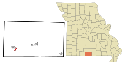
Location of Sundown, Missouri
|
|
| Country | United States |
| State | Missouri |
| County | Ozark |
| Area | |
| • Total | 1.86 sq mi (4.83 km2) |
| • Land | 1.46 sq mi (3.78 km2) |
| • Water | 0.40 sq mi (1.05 km2) |
| Elevation | 771 ft (235 m) |
| Population
(2020)
|
|
| • Total | 62 |
| • Density | 42.47/sq mi (16.39/km2) |
| Time zone | UTC-6 (Central (CST)) |
| • Summer (DST) | UTC-5 (CDT) |
| FIPS code | 29-71628 |
| GNIS ID | 1669607 |
Sundown is a small place in Ozark County, Missouri, United States. It is called an "unincorporated community" and a "census-designated place." This means it's a group of homes that isn't officially a town with its own local government. The government counts the people living there for official records.
In 2020, about 62 people lived in Sundown. Before 2000, Sundown was a "village." But in 2000, it stopped being an official village. This process is called "disincorporation."
Where is Sundown Located?
Sundown is found on the east side of the Little North Fork White River. This river arm is part of Bull Shoals Lake. The community is south of U.S. Route 160. It is about 1.5 miles southwest of Isabella. Sundown is also two miles southeast of Theodosia.
The United States Census Bureau says Sundown covers about 1.86 square miles (4.83 square kilometers). All of this area is land.
Who Lives in Sundown?
| Historical population | |||
|---|---|---|---|
| Census | Pop. | %± | |
| 2020 | 62 | — | |
| U.S. Decennial Census | |||
In 2000, there were 38 people living in Sundown. These people lived in 17 different homes. Most of the people were White.
The people living in Sundown were of different ages.
- About 16% were under 18 years old.
- About 34% were between 45 and 64 years old.
- Another 34% were 65 years old or older.
The average age in Sundown was 60 years old.
See also
 In Spanish: Sundown (Misuri) para niños
 | Claudette Colvin |
 | Myrlie Evers-Williams |
 | Alberta Odell Jones |

