List of counties in Missouri facts for kids
Quick facts for kids Independent city and Counties of Missouri |
|
|---|---|
| Location | State of Missouri |
| Number | 114 counties 1 independent city |
| Populations | 1,907 (Worth) – 987,059 (St. Louis) |
| Areas | 266 square miles (690 km2) (Worth) – 1,179 square miles (3,050 km2) (Texas) |
| Government | County government |
| Subdivisions | cities, towns, unincorporated communities, census designated place |
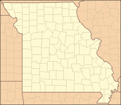
Missouri has 114 counties and one special independent city, St. Louis. Counties are like smaller sections of a state. They help organize local government and services.
When the United States bought the Louisiana Purchase lands, Missouri was part of the Missouri Territory. In 1812, five original counties were created: Cape Girardeau, New Madrid, Saint Charles, Saint Louis, and Ste. Genevieve. Most other counties were later formed from parts of these first five. In 1836, six more counties were added in an area called the Platte Purchase. These were Andrew, Atchison, Buchanan, Holt, Nodaway, and Platte.
Contents
What Do Counties Do?
In Missouri, counties are an important level of government. They are between the state government and city governments. Counties are in charge of many things that affect people's daily lives.
County Responsibilities
Counties have several key jobs. These include taking care of local roads. They also provide security by having a sheriff and other law enforcement. Counties are also responsible for prosecuting criminals and collecting taxes.
County Leaders
People in counties vote for their leaders. Some important elected officials at the county level are the sheriff, who is the chief law enforcement officer. There is also a prosecuting attorney, who handles legal cases. An assessor is also elected to figure out property values for taxes.
How Counties Got Their Names
Many counties in Missouri are named after important people. These include politicians, war heroes, and explorers. Some are also named after natural resources or old U.S. territories.
Examples of County Names
For example, Cass County was first named Van Buren County. It was named after President Martin Van Buren. But its name was changed to Cass County in 1848. This was to support Lewis Cass, who was running against Van Buren for president. Other counties are named after famous people like Daniel Boone (Boone County) or Benjamin Franklin (Franklin County). Some are named after rivers, like the Chariton River for Chariton County.
St. Louis: An Independent City
The city of St. Louis is unique in Missouri. It is an independent city. This means it is not part of any county.
Why St. Louis is Independent
In 1876, the people living in St. Louis voted to separate from St. Louis County. This made it an independent city. St. Louis is one of only three independent cities in the entire United States outside of Virginia. The other two are Baltimore, Maryland, and Carson City, Nevada.
Missouri's Population and Size
Missouri has a large population spread across its many counties. The population figures are based on the 2023 Census estimate.
Population and Area Facts
The total population of Missouri is about 6,196,156 people. This is a small increase from 2020. On average, a Missouri county has about 53,880 people. St. Louis County is the most populated, with about 987,059 residents. The least populated is Worth County, with only about 1,907 people.
The average size of a Missouri county is about 599 square miles (1,551 square kilometers). Texas County is the largest county, covering 1,179 square miles (3,054 square kilometers). The smallest is St. Louis city, which is about 61.9 square miles (160 square kilometers).
Understanding County Codes
The U.S. government uses special codes to identify each county. These are called Federal Information Processing Standard (FIPS) codes.
What FIPS Codes Mean
Each county has a unique FIPS code. These codes help link to information about each county from the United States Census Bureau. To make sure you're looking at a Missouri county, you use Missouri's FIPS code, which is 29. For example, Adair County's full FIPS code is 29001.
Counties in Missouri
Here is a small sample of counties in Missouri. There are 114 counties in total. This table shows some key details for a few of them.
| County |
FIPS code | County seat | Est. | Formed from | Etymology | Population | Area | Map |
|---|---|---|---|---|---|---|---|---|
| Adair County | 001 | Kirksville | 1841 | Macon County | John Adair (1757–1840), pioneer, soldier, and seventh Governor of Kentucky | 25,122 | 568 sq mi (1,471 km2) |
 |
| Boone County | 019 | Columbia | 1820 | Howard County | Daniel Boone (1734–1820), American pioneer and hunter | 189,463 | 685 sq mi (1,774 km2) |
 |
| Cape Girardeau County | 031 | Jackson | 1812 | One of the five original counties | A rock promontory over the Mississippi River and Ensign Sieur Jean Baptiste de Girardot, a French officer and early explorer of the region | 82,984 | 579 sq mi (1,500 km2) |
 |
| Cass County | 037 | Harrisonville | 1833 | Jackson County | Lewis Cass (1782–1866), senator from Michigan | 111,732 | 699 sq mi (1,810 km2) |
 |
| Franklin County | 071 | Union | 1818 | St. Louis County | Benjamin Franklin (1706–1790), writer, publisher, orator, and one of the Founding Fathers of the United States | 106,404 | 922 sq mi (2,388 km2) |
 |
| Jackson County | 095 | Independence, Kansas City |
1826 | Lillard (now Lafayette) County | Andrew Jackson (1767–1845), U.S. Senator from Tennessee and later 7th President of the United States from 1829 to 1837 | 718,560 | 605 sq mi (1,567 km2) |
 |
| New Madrid County | 143 | New Madrid | 1812 | One of the five original counties | Madrid, Spain | 15,424 | 678 sq mi (1,756 km2) |
 |
| Saint Charles County | 183 | Saint Charles | 1812 | One of the five original counties | St. Charles Borromeo (1538–1584), an Italian saint and cardinal of the Roman Catholic Church | 416,659 | 561 sq mi (1,453 km2) |
 |
| Saint Louis County | 189 | Clayton | 1812 | One of the five original counties | King Louis IX (1214–1270), King of France from 1226 until his death | 987,059 | 508 sq mi (1,316 km2) |
 |
| Saint Louis City | 510 | St. Louis | 1876 | Created in 1876 when city residents voted to secede from St. Louis County | King Louis IX (1214–1270), King of France from 1226 until his death | 281,754 | 61.9 sq mi (160 km2) |
 |
| Texas County | 215 | Houston | 1843 | Shannon and Wright counties | Republic of Texas | 25,619 | 1,179 sq mi (3,054 km2) |
 |
| Worth County | 227 | Grant City | 1861 | Gentry County | William J. Worth (1794–1849), a United States general during the Mexican–American War | 1,907 | 266 sq mi (689 km2) |
 |
Former County Names
Some counties in Missouri have changed their names over time. This table shows a few examples of counties that used to be called something else.
| County | Etymology | Changed to |
|---|---|---|
| Allen County |
Unknown
|
Atchison County in 1845 |
| Ashley County | William Henry Ashley (1778–1838), early settler | Texas County in 1845 upon organization |
| Decatur County | Stephen Decatur (1779–1820), American naval officer | Ozark County in 1845 |
| Kinderhook County | Kinderhook, New York, birthplace of Martin Van Buren | Camden County in 1843 |
| Lillard County | James Lillard of Tennessee, who served in the first state legislature of Missouri | Lafayette County in 1825 |
| Van Buren County | Martin Van Buren (1782–1862), eighth President of the United States and also Vice President under Andrew Jackson | Cass County in 1849 in honor of Van Buren's opponent in the presidential election of 1848 |
See also
 In Spanish: Anexo:Condados de Misuri para niños
- List of cities in Missouri
- List of municipalities in Missouri
- List of U.S. counties by population
- Missouri census statistical areas
- Demographics of Missouri
 | Valerie Thomas |
 | Frederick McKinley Jones |
 | George Edward Alcorn Jr. |
 | Thomas Mensah |


