Audrain County, Missouri facts for kids
Quick facts for kids
Audrain County
|
||
|---|---|---|

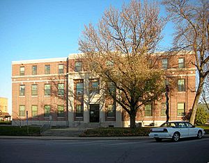
The Audrain County Courthouse in Mexico
|
||
|
||
| Nickname(s):
Biofuel Capital of Missouri
|
||

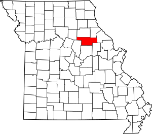
Location within the U.S. state of Missouri
|
||
 Missouri's location within the U.S. |
||
| Country | ||
| State | ||
| Founded | December 17, 1836 | |
| Named for | James Hunter Audrain | |
| Seat | Mexico | |
| Largest city | Mexico | |
| Area | ||
| • Total | 697 sq mi (1,810 km2) | |
| • Land | 692 sq mi (1,790 km2) | |
| • Water | 4.6 sq mi (12 km2) 0.7% | |
| Population
(2020)
|
||
| • Total | 24,962 | |
| • Estimate
(2021)
|
24,982 |
|
| • Density | 35.813/sq mi (13.828/km2) | |
| Time zone | UTC−6 (Central) | |
| • Summer (DST) | UTC−5 (CDT) | |
| Congressional districts | 4th, 6th | |
Audrain County is a county located in the middle part of the U.S. state of Missouri. In 2020, about 24,962 people lived there. Its main city and government center is Mexico. The county was officially started on December 13, 1836. It was named after Colonel James Hunter Audrain. He fought in the War of 1812 and later became a state lawmaker.
Contents
History
Audrain County was formed from land that didn't belong to any specific county before 1836. Parts of this area were managed by other counties like Montgomery or Boone. So, old records for places now in Audrain might show them as being in a different county.
During the American Civil War, Audrain County was divided. About half the people supported the Union, and half supported the Confederacy. General Ulysses Grant, who later became a U.S. President, lived there for a short time during the war.
Many early settlers in Audrain County came from states like Kentucky and Tennessee. They brought their ways of life with them. This included growing crops like hemp and tobacco. The county was part of an area sometimes called "Little Dixie." This name came from the cultural traditions brought by these settlers.
Geography
Audrain County covers a total area of 697 square miles. Most of this is land, about 692 square miles. The rest, about 4.6 square miles, is water.
Neighboring Counties
- Monroe County (north)
- Ralls County (northeast)
- Pike County (east)
- Montgomery County (southeast)
- Callaway County (south)
- Boone County (southwest)
- Randolph County (northwest)
Main Roads
Population Facts
| Historical population | |||
|---|---|---|---|
| Census | Pop. | %± | |
| 1840 | 1,949 | — | |
| 1850 | 3,506 | 79.9% | |
| 1860 | 8,075 | 130.3% | |
| 1870 | 12,307 | 52.4% | |
| 1880 | 19,732 | 60.3% | |
| 1890 | 22,074 | 11.9% | |
| 1900 | 21,160 | −4.1% | |
| 1910 | 21,687 | 2.5% | |
| 1920 | 20,589 | −5.1% | |
| 1930 | 22,077 | 7.2% | |
| 1940 | 22,673 | 2.7% | |
| 1950 | 23,829 | 5.1% | |
| 1960 | 26,079 | 9.4% | |
| 1970 | 25,362 | −2.7% | |
| 1980 | 26,458 | 4.3% | |
| 1990 | 23,599 | −10.8% | |
| 2000 | 25,853 | 9.6% | |
| 2010 | 25,529 | −1.3% | |
| 2020 | 24,962 | −2.2% | |
| 2021 (est.) | 24,982 | −2.1% | |
| U.S. Decennial Census 1790-1960 1900-1990 1990-2000 2010-2020 |
|||
Audrain County is part of the Mexico, MO Micropolitan Statistical Area. This means it's a smaller city area with strong economic ties to a larger region. It's also part of the bigger Columbia-Moberly-Mexico, MO Combined Statistical Area.
In 2010, there were 25,529 people living in the county. There were 9,844 households, which are groups of people living together. The population density was about 37 people per square mile.
Most people in Audrain County are White (89.8%). Other groups include Black or African American (6.4%) and Asian (0.5%). About 2.6% of the population was Hispanic or Latino. Many residents have German, American, or Irish backgrounds.
The average age in the county was 38 years old. About 24.6% of the population was under 18. About 16.9% were 65 years or older.
The average income for a household was about $32,057. For families, it was about $40,448. About 14.8% of all people in the county lived below the poverty line.
Religion
Audrain County is located near the northern edge of the Bible Belt. This is a region where Protestant Christianity is very common. The most popular religions in Audrain County are Southern Baptists, Roman Catholics, and Christian Churches and Churches of Christ.
2020 Census Information
| Race | Number | Percent |
|---|---|---|
| White (not Hispanic) | 21,450 | 86% |
| Black or African American (not Hispanic) | 1,304 | 5.22% |
| Native American (not Hispanic) | 63 | 0.3% |
| Asian (not Hispanic) | 114 | 0.5% |
| Pacific Islander (not Hispanic) | 2 | 0.01% |
| Other/Mixed (not Hispanic) | 1,298 | 5.2% |
| Hispanic or Latino | 731 | 3% |
Education
Public Schools
- Community R-VI School District – Laddonia
- Community Elementary School (Grades PK-5)
- Community High School (Grades 6-12)
- Mexico School District No. 59 – Mexico
- McMillan Early Learning Center (Grades PK-K)
- Hawthorne Elementary School (Grades K-5)
- Eugene Field Elementary School (Grades K-5)
- Mexico Middle School (Grades 6-8)
- Mexico High School (Grades 9-12)
- Van-Far R-I School District – Vandalia
- Van-Far Elementary School (Grades PK-6)
- Van-Far High School (Grades 7-12)
Private Schools
- Sunnydale Seventh-day Adventist Elementary School – Centralia (Grades 2-9) – Seventh-day Adventist
- St. Brendan School – Mexico (Grades PK-8) – Roman Catholic
- St. Joseph Elementary School – Martinsburg (Grades K-9) – Roman Catholic
- Missouri Military Academy – Mexico (Grades 7-12)
Public Libraries
- Mexico-Audrain County Library District
Communities
Cities
Villages
Unincorporated Communities
Townships
Audrain County is divided into eight townships:
- Cuivre
- Linn
- Loutre
- Prairie
- Saling
- Salt River
- South Fork
- Wilson
Notable People
- Tom Bass, a famous horse trainer
- Cookie Belcher, a former professional basketball player
- Kit Bond, a former U.S. Senator and Governor of Missouri
- Jason Brookins, a former NFL running back for the Baltimore Ravens
- Charles Henry Hardin, a former Governor of Missouri
- Anna J. Harrison, the first female president of the American Chemical Society
- Howard Kindig, a former NFL player who won the Super Bowl
- Tyronn Lue, a head coach for the Los Angeles Clippers and former NBA player
- Prim Siripipat, a television anchor
See also
 In Spanish: Condado de Audrain para niños
 | Bessie Coleman |
 | Spann Watson |
 | Jill E. Brown |
 | Sherman W. White |


