Montgomery County, Missouri facts for kids
Quick facts for kids
Montgomery County
|
|
|---|---|

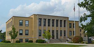
The Montgomery County Courthouse in Montgomery City
|
|

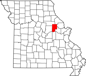
Location within the U.S. state of Missouri
|
|
 Missouri's location within the U.S. |
|
| Country | |
| State | |
| Founded | December 14, 1818 |
| Named for | Richard Montgomery |
| Seat | Montgomery City |
| Largest city | Montgomery City |
| Area | |
| • Total | 542 sq mi (1,400 km2) |
| • Land | 536 sq mi (1,390 km2) |
| • Water | 5.8 sq mi (15 km2) 1.1% |
| Population
(2020)
|
|
| • Total | 11,322 |
| • Density | 20.889/sq mi (8.065/km2) |
| Time zone | UTC−6 (Central) |
| • Summer (DST) | UTC−5 (CDT) |
| Congressional district | 3rd |
Montgomery County is a place in the middle-eastern part of Missouri, a state in the United States. In 2020, about 11,322 people lived here. Its main town, or "county seat," is Montgomery City.
The county got its name from Richard Montgomery. He was a general in the American Revolutionary War. He died in 1775 while trying to take over Quebec City, Canada.
Montgomery County is part of an area called the Missouri Rhineland. It is located about halfway between the cities of Columbia and St. Louis.
Contents
History of Montgomery County
People have lived in Montgomery County for a very long time. There is proof that Native American groups lived here as far back as 10,000 years ago. This was during a time called the Archaic period.
Scientists found an old site at Graham Cave near the Loutre River. This discovery showed how ancient people lived in the area.
Early European Settlers
In the early 1800s, more European settlers began to arrive. Before this, French trappers and British and American fur traders had explored the area.
The Loutre Island area is known for towns like Rhineland and Starkenburg. These towns were started by German immigrants in the mid-1800s. However, the area was first settled by people from southern states like Kentucky and Virginia.
The southern part of the county is known for its German heritage. But the northern part is more like Missouri's "Little Dixie" region. This is why Montgomery County is sometimes called the "Gateway to Little Dixie."
Old Churches and Shrines
An early church in the county was a log building. It is still used as a chapel today. St. Martin's Church in Starkenburg was built in 1873. It is now a historic site. Above its entrance, it says: "This is the House Of God and the Gate Of Heaven."
Starkenburg is also home to the Shrine of Our Lady of Sorrows. This Catholic church was built in the early 1900s. It is also a historic site. People can visit outdoor areas there to pray. These areas show scenes from the Stations of the Cross, Mount Calvary, and the Holy Sepulchre.
Starkenburg is located away from the Missouri River. After a big flood in 1993, people in Rhineland moved their homes. They rebuilt about 1.5 miles (2.4 km) away from the river to be safer.
Geography
Montgomery County covers a total area of 542 square miles (1,400 km²). Most of this area, 536 square miles (1,388 km²), is land. Only 5.8 square miles (15 km²), or 1.1%, is water.
Neighboring Counties
Montgomery County shares borders with several other counties:
- Audrain County (to the northwest)
- Pike County (to the northeast)
- Lincoln County (to the east)
- Warren County (to the southeast)
- Gasconade County (to the south)
- Callaway County (to the west)
- Osage County (to the southwest)
Main Roads
These are the most important roads that go through Montgomery County:
 Interstate 70
 U.S. Route 40
 Route 19
 Route 94
 Route 161
Climate
The weather in Montgomery County changes with the seasons. It has warm summers and cold winters. Here's a quick look at the average temperatures and rainfall:
|
||||||||||||||||||||||||||||||||||||||||||||||||||||||||||||||||||||||||||||||||||||||||||||||||
Population and People
| Historical population | |||
|---|---|---|---|
| Census | Pop. | %± | |
| 1820 | 3,074 | — | |
| 1830 | 3,902 | 26.9% | |
| 1840 | 4,371 | 12.0% | |
| 1850 | 5,489 | 25.6% | |
| 1860 | 9,718 | 77.0% | |
| 1870 | 10,405 | 7.1% | |
| 1880 | 16,249 | 56.2% | |
| 1890 | 16,850 | 3.7% | |
| 1900 | 16,571 | −1.7% | |
| 1910 | 15,604 | −5.8% | |
| 1920 | 15,233 | −2.4% | |
| 1930 | 13,011 | −14.6% | |
| 1940 | 12,442 | −4.4% | |
| 1950 | 11,555 | −7.1% | |
| 1960 | 11,097 | −4.0% | |
| 1970 | 11,000 | −0.9% | |
| 1980 | 11,537 | 4.9% | |
| 1990 | 11,355 | −1.6% | |
| 2000 | 12,136 | 6.9% | |
| 2010 | 12,236 | 0.8% | |
| 2020 | 11,322 | −7.5% | |
| U.S. Decennial Census 1790-1960 1900-1990 1990-2000 2010-2015 |
|||
In 2000, there were 12,136 people living in Montgomery County. About 25% of the people were under 18 years old. The average age was 39 years. For every 100 females, there were about 98 males.
Most people in the county are White. There are also smaller groups of Black or African American, Native American, and Asian people. Some people are of Hispanic or Latino background. Many families living here have German, American, English, or Irish roots.
Population in 2020
The 2020 Census showed that 11,322 people lived in Montgomery County.
| Race | Number of People | Percentage |
|---|---|---|
| White (not Hispanic) | 10,444 | 92.25% |
| Black or African American (not Hispanic) | 101 | 0.9% |
| Native American (not Hispanic) | 22 | 0.2% |
| Asian (not Hispanic) | 50 | 0.44% |
| Pacific Islander (not Hispanic) | 5 | 0.04% |
| Other/Mixed (not Hispanic) | 471 | 4.2% |
| Hispanic or Latino | 229 | 2.02% |
Education
Montgomery County has several schools for students of all ages.
Public Schools
There are two main public school districts in the county:
- Montgomery County R-II School District (mc-wildcats.org)
- Montgomery County Elementary School (for grades PK–5)
- Jonesburg Elementary School (for grades PK–5) in Jonesburg
- Montgomery County Middle School (for grades 6–8)
- Montgomery County High School (for grades 9–12)
- Wellsville-Middletown R-I School District (wmr1.k12.mo.us)
- Wellsville Elementary School (for grades PK–6)
- Wellsville High School (for grades 7–12)
Private Schools
- Immaculate Conception School (mcicparish.org) in Montgomery City is a Roman Catholic school for grades PK-6.
Public Libraries
You can find books and other resources at these public libraries:
- Montgomery City Public Library
- Wellsville Public Library
Communities
Montgomery County has several towns and villages.
Cities
- Bellflower
- High Hill
- Jonesburg
- McKittrick
- Middletown
- Montgomery City (this is the county seat)
- New Florence
- Wellsville
Village
Census-Designated Places
These are areas that are like towns but are not officially incorporated as cities or villages:
Other Unincorporated Places
These are smaller communities that are not officially part of a city or village:
See also
 In Spanish: Condado de Montgomery (Misuri) para niños
 | Victor J. Glover |
 | Yvonne Cagle |
 | Jeanette Epps |
 | Bernard A. Harris Jr. |

